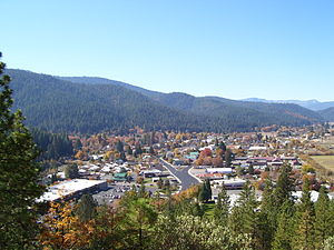
Country:
Region:
City:
Latitude and Longitude:
Time Zone:
Postal Code:
IP information under different IP Channel
ip-api
Country
Region
City
ASN
Time Zone
ISP
Blacklist
Proxy
Latitude
Longitude
Postal
Route
Luminati
Country
Region
ca
City
quincy
ASN
Time Zone
America/Los_Angeles
ISP
PLUMAS-SIERRA-TELECOMMUNICATIONS
Latitude
Longitude
Postal
IPinfo
Country
Region
City
ASN
Time Zone
ISP
Blacklist
Proxy
Latitude
Longitude
Postal
Route
db-ip
Country
Region
City
ASN
Time Zone
ISP
Blacklist
Proxy
Latitude
Longitude
Postal
Route
ipdata
Country
Region
City
ASN
Time Zone
ISP
Blacklist
Proxy
Latitude
Longitude
Postal
Route
Popular places and events near this IP address

East Quincy, California
Census-designated place in California, United States
Distance: Approx. 5349 meters
Latitude and longitude: 39.93527778,-120.90777778
East Quincy is a census-designated place (CDP) in Plumas County, California, United States. The population was 2,489 at the 2010 census, up from 2,398 at the 2000 census.

Meadow Valley, California
Census-designated place in California, United States
Distance: Approx. 7938 meters
Latitude and longitude: 39.93694444,-121.06194444
Meadow Valley is a census-designated place (CDP) in Plumas County, California, United States. The population was 453 at the 2020 census, down from 464 at the 2010 census.
Quincy, California
Census-designated place in California, United States
Distance: Approx. 2075 meters
Latitude and longitude: 39.93638889,-120.94805556
Quincy (formerly Quinsy) is a census-designated place and the county seat of Plumas County, California. The population was 1,630 during the 2020 Census, down from 1,728 during the 2010 Census, and 1,879 during the 2000 Census.

Elizabethtown, California
Former settlement in California, United States
Distance: Approx. 4143 meters
Latitude and longitude: 39.963839,-120.957081
Elizabethtown, California was a California Gold Rush town that began in 1852 in Plumas County, California. It was named after a woman in the miners camp called Elizabeth Stark Blakesley. It is said that the value of gold taken from the Elizabethtown area ran into the millions of dollars.
Feather River College
Community college in Quincy, California, U.S.
Distance: Approx. 2533 meters
Latitude and longitude: 39.95065,-120.96985
Feather River College (FRC) is a community college in Quincy, California. The school serves an annual full-time enrolled student body of approximately 1,500 students.
Gansner Field
Airport in Plumas County, California
Distance: Approx. 2741 meters
Latitude and longitude: 39.94388889,-120.94527778
Gansner Field (IATA: GNF, FAA LID: 2O1) is a public use airport owned by and located in Plumas County, California, United States. The airport is one nautical mile (2 km) north of the center of Quincy, California. It is included in the National Plan of Integrated Airport Systems for 2011–2015, which categorized it as a general aviation facility.
Silongkoyo, California
Former settlement in California, United States
Distance: Approx. 2280 meters
Latitude and longitude: 39.93666667,-120.94555556
Silongkoyo is a former Maidu village in Plumas County, California. It lay at an elevation of 3435 feet (1047 m). The site now lies within Quincy.
Spanish Ranch, California
Unincorporated community in California, United States
Distance: Approx. 7894 meters
Latitude and longitude: 39.95083333,-121.05722222
Spanish Ranch is an unincorporated community in Plumas County, California. It lies at an elevation of 3668 feet (1118 m). Spanish Ranch is located 1.25 miles (2.0 km)north- northeast of Meadow Valley.
Plumas County Museum
County Museum in Quincy California, United States
Distance: Approx. 2064 meters
Latitude and longitude: 39.9356,-120.9477
The Plumas County Museum is a 501(c)3 organization and historical museum located in Quincy, California. Exhibits focus on Plumas County, including the Maidu people, the California Gold Rush, the logging industry, and the local community. In addition to artifacts on display, the museum houses an archive of over 5,000 photographs, as well as documents, and a 1,000-item map collection.

Plumas County Superior Court
California superior court with jurisdiction over Plumas County
Distance: Approx. 2064 meters
Latitude and longitude: 39.9363,-120.94815
The Superior Court of California, County of Plumas, also known as the Plumas County Superior Court or Plumas Superior Court, is the California superior court with jurisdiction over Plumas County.
Pioneer Schoolhouse (Plumas, California)
Historical Landmark in Quincy, United States
Distance: Approx. 4803 meters
Latitude and longitude: 39.938,-120.915
Pioneer School House in Quincy, California was built in 1857 by the residents of Plumas County. The School served the residents of the American Valley, a plain with an elevation of 3415 feet. American Valley is near East Quincy and Quincy Junction.

Plumas House
Historical Landmark in Quincy, United States
Distance: Approx. 2060 meters
Latitude and longitude: 39.936,-120.948
Plumas House was a historical building in Quincy, California. The site of the Plumas House building is a California Historical Landmark No. 480.
Weather in this IP's area
few clouds
2 Celsius
-2 Celsius
2 Celsius
2 Celsius
1024 hPa
67 %
1024 hPa
879 hPa
10000 meters
3.55 m/s
7.29 m/s
43 degree
20 %
06:39:13
16:55:52
