Country:
 Peru
PeruRegion:
City:
Latitude and Longitude:
Time Zone:
Postal Code:
IP information under different IP Channel
ip-api
Country
Region
City
ASN
Time Zone
ISP
Blacklist
Proxy
Latitude
Longitude
Postal
Route
IPinfo
Country
Region
City
ASN
Time Zone
ISP
Blacklist
Proxy
Latitude
Longitude
Postal
Route
MaxMind
Country
Region
City
ASN
Time Zone
ISP
Blacklist
Proxy
Latitude
Longitude
Postal
Route
Luminati
Country
PERegion
lma
City
lima
ASN
Time Zone
America/Lima
ISP
WIN EMPRESAS S.A.C.
Latitude
Longitude
Postal
db-ip
Country
Region
City
ASN
Time Zone
ISP
Blacklist
Proxy
Latitude
Longitude
Postal
Route
ipdata
Country
Region
City
ASN
Time Zone
ISP
Blacklist
Proxy
Latitude
Longitude
Postal
Route
Popular places and events near this IP address

University of Lima
Private nonprofit university in Lima, Peru
Distance: Approx. 2087 meters
Latitude and longitude: -12.0848,-76.9708
The University of Lima (Spanish: Universidad de Lima; IPA: [uniβeɾsiˈðað ðe ˈlima]; ) is a private nonprofit university in Lima, Peru. It was founded in 1962. The decision to create the University of Lima was made in the early 1960s by a group of university professors, along with commerce and industry representatives gathered in the Civil Association PRODIES (Promotion of Industrial Development through Higher Education).
Colegio Franklin Delano Roosevelt, The American School of Lima
School in Lima, Peru
Distance: Approx. 1325 meters
Latitude and longitude: -12.078,-76.972
Colegio Franklin Delano Roosevelt is a K–12 school in Lima, Peru, founded by a group of American families in the mid-1940s, with the intent of providing an American Education. While its first campus was in the San Isidro District, it eventually moved to the current location in Camacho, La Molina. There are approximately 1,590 students.

San Luis District, Lima
District in Lima, Peru
Distance: Approx. 2808 meters
Latitude and longitude: -12.07555556,-76.99611111
San Luis is a district of the Lima Province in Peru. In San Luis the National Sports Village is located in charge of the Peruvian Sports Institute, which has facilities for the practice of various sports (athletics, cycling, volleyball, swimming, softball and baseball). In addition, within its facilities is the headquarters of the Peruvian Olympic Committee and the Peruvian Football Federation (training place of the Peruvian Football Team, both senior and junior categories.
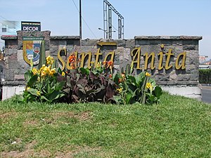
Santa Anita District
District in Lima, Peru
Distance: Approx. 2977 meters
Latitude and longitude: -12.04305556,-76.95833333
Santa Anita is a district of the Lima Province in Peru. It is part of city of Lima. Officially established as a district on October 25, 1989, from parts of Ate and El Agustino separated by the Rio Surco, a ditch which went all the way to Santiago de Surco.

Lima Peru Temple
Distance: Approx. 2568 meters
Latitude and longitude: -12.069713,-76.948897
The Lima Peru Temple is the 38th operating temple of the Church of Jesus Christ of Latter-day Saints (LDS Church).

Hipódromo de Monterrico
Distance: Approx. 3022 meters
Latitude and longitude: -12.092787,-76.977275
The Hipódromo de Monterrico is a Thoroughbred horse racing facility opened in 1960 in Lima, Peru. Operated by the Jockey Club del Peru, it has a one and one-eight mile dirt racetrack with a one-mile inside track for turf racing.
University of San Martín de Porres
Private nonprofit university in Lima, Peru
Distance: Approx. 2317 meters
Latitude and longitude: -12.0454,-76.97
The University of San Martin de Porres (USMP) is a private nonprofit university located in the city of Lima, Peru. It was founded by the Dominican Order of the Catholic Church in 1962.

Universidad San Ignacio de Loyola
Private institution for higher education and research in Lima, Peru
Distance: Approx. 2348 meters
Latitude and longitude: -12.072536,-76.951656
St. Ignatius of Loyola University (Spanish: Universidad San Ignacio de Loyola) (USIL) is a private institution for higher education and research in Lima, Peru. It was founded in 1995, as part of the Educational Corporation San Ignacio de Loyola, by Raúl Diez Canseco.
Jockey Club del Perú
Distance: Approx. 2940 meters
Latitude and longitude: -12.0924,-76.9747
The Jockey Club del Perú in Lima is one of the leading racecourses in Peru.
Women's University of the Sacred Heart
University in Lima, Peru
Distance: Approx. 935 meters
Latitude and longitude: -12.0717,-76.9658
The Women's University of the Sacred Heart (UNIFÉ) is a private university for women, located in the city of Lima, Peru. It was founded and sponsored by the Congregation of Sisters of the Sacred Heart of Jesus of the Catholic Church on December 24, 1962. Its headquarters are in the district of La Molina.

La Atarjea Water Treatment Plant
Water treatment plant in Lima, Peru
Distance: Approx. 3081 meters
Latitude and longitude: -12.0387,-76.9762
La Atarjea is a water treatment plant located in El Agustino, a district of Lima, Peru. Originally a spring, it serves the headquarters of SEDAPAL, the city's water treatment company that also services Callao.

Colegio Sagrados Corazones Recoleta
School in Lima, Peru
Distance: Approx. 1571 meters
Latitude and longitude: -12.075,-76.961
The Colegio de los Sagrados Corazones Recoleta is a private Catholic school in La Molina District, Lima, Peru. Founded in 1893 by a French mission of the Congregation of the Sacred Hearts of Jesus and Mary as a all-boys school in central Lima, it is currently a mixed-sex school.
Weather in this IP's area
broken clouds
16 Celsius
15 Celsius
16 Celsius
16 Celsius
1011 hPa
77 %
1011 hPa
983 hPa
10000 meters
4.63 m/s
190 degree
75 %
05:59:13
18:03:54