Country:
 Spain
SpainRegion:
City:
Latitude and Longitude:
Time Zone:
Postal Code:
IP information under different IP Channel
ip-api
Country
Region
City
ASN
Time Zone
ISP
Blacklist
Proxy
Latitude
Longitude
Postal
Route
IPinfo
Country
Region
City
ASN
Time Zone
ISP
Blacklist
Proxy
Latitude
Longitude
Postal
Route
MaxMind
Country
Region
City
ASN
Time Zone
ISP
Blacklist
Proxy
Latitude
Longitude
Postal
Route
Luminati
Country
 US
USASN
Time Zone
America/Chicago
ISP
ACCENTURE
Latitude
Longitude
Postal
db-ip
Country
Region
City
ASN
Time Zone
ISP
Blacklist
Proxy
Latitude
Longitude
Postal
Route
ipdata
Country
Region
City
ASN
Time Zone
ISP
Blacklist
Proxy
Latitude
Longitude
Postal
Route
Popular places and events near this IP address

Puerta del Sol
Square in Madrid, Spain
Distance: Approx. 22 meters
Latitude and longitude: 40.41694444,-3.70361111
The Puerta del Sol (Spanish: [ˈpweɾta ðel ˈsol], English: "Gate of the Sun") is a public square in Madrid, one of the best known and busiest places in the city. This is the centre (Km 0) of the radial network of Spanish roads. The square also contains the famous clock whose bells mark the traditional eating of the Twelve Grapes and the beginning of a new year.

Tetuán, Madrid
City district in Community of Madrid, Spain
Distance: Approx. 135 meters
Latitude and longitude: 40.41722222,-3.70527778
Tetuán (Spanish pronunciation: [teˈtwan], [tetuˈan]) is a district of Madrid, Spain.

Cafetería Rolando bombing
1974 bombing in Madrid
Distance: Approx. 83 meters
Latitude and longitude: 40.41611111,-3.70416667
The Cafetería Rolando bombing was an attack on 13 September 1974 at the Rolando cafe in Calle del Correo, Madrid, Spain which killed 13 people and wounded 71.

Mariblanca
Distance: Approx. 58 meters
Latitude and longitude: 40.41694444,-3.70444444
The statues known as Mariblanca are female figures of uncertain origin which may relate to the fertility goddesses Venus or Fortuna. The name, which is common in Spanish relates to a statue which was purchased in the year 1625 by a Florentine merchant Ludovico Turchi as a gift to crown the lost Fountain of Faith in Madrid. It is now the only element that remains of this monumental fountain, which was located on the church of Good Faith, which formerly stood in the Puerta del Sol.

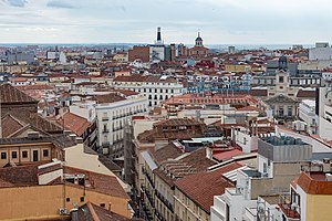
Madrid
Capital and largest city of Spain
Distance: Approx. 42 meters
Latitude and longitude: 40.41694444,-3.70333333
Madrid ( mə-DRID; Spanish: [maˈðɾið] ) is the capital and most populous city of Spain. The city has almost 3.4 million inhabitants and a metropolitan area population of approximately 7 million. It is the second-largest city in the European Union (EU), and its monocentric metropolitan area is the second-largest in the EU. The municipality covers 604.3 km2 (233.3 sq mi) geographical area.
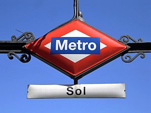
Sol (Madrid Metro)
Madrid Metro station
Distance: Approx. 14 meters
Latitude and longitude: 40.4167635,-3.7036371
Sol [ˈsol] is a station on Line 1, Line 2 and Line 3 of the Madrid Metro. It is located in Zone A and is the most central station on the Metro, located at the Puerta del Sol square. Because of its location, it is one of the busiest stations of the Madrid Metro.

Statue of the Bear and the Strawberry Tree
Public sculpture in Madrid
Distance: Approx. 120 meters
Latitude and longitude: 40.417,-3.7024
The Statue of the Bear and the Strawberry Tree (in Spanish “El Oso y el Madroño”) is a sculpture from the second half of the 20th century, situated in the Spanish city of Madrid. It represents the coat of arms of Madrid and is found on the east side of the Puerta del Sol, between Calle de Alcalá and Carrera de San Jerónimo, in the historical centre of the capital.

Convento de San Felipe el Real
Convent in Madrid, Spain
Distance: Approx. 112 meters
Latitude and longitude: 40.41641389,-3.70501111
The now defunct Convento de San Felipe el Real (English: Convent of Saint Philip the Royal) (briefly called as San Felipe el Real) was a former Madrilenian convent of Calced Augustinian monks, located at the beginning of Calle Mayor in Madrid, next to the Puerta del Sol. Built between 16th and 17th centuries, was rise on a large pedestal (with protected perimeter of railings), was part of it a famous talking shop of the city (the Steps of San Felipe). One of its famous guests was Friar Luis de León.

Iglesia del Buen Suceso
Distance: Approx. 98 meters
Latitude and longitude: 40.41685833,-3.70263333
The Iglesia de Nuestra Señora del Buen Suceso, commonly known as Iglesia del Buen Suceso was a church of Madrid that delimited the eastern part of the Puerta del Sol (Madrid). The church comes from a remodeling of the Hospital Real de la Corte (Royal Hospital of the Court) (built in 1483). Was doing functions of church and hospital since 1590.
Sol (Madrid)
Neighborhood in Madrid, Madrid, Spain
Distance: Approx. 17 meters
Latitude and longitude: 40.41666667,-3.70388889
Sol is an administrative neighborhood (barrio) of Madrid belonging to the district of Centro. It has a total area of around 44.5 hectares (less than 0.1% out of the total municipal area). Hugely affected by the impact of tourism, by 2018 it had over 2 tourists per 1 permanent dweller.

Royal House of the Post Office
Building in Madrid, Spain
Distance: Approx. 45 meters
Latitude and longitude: 40.4164,-3.7038
The Royal House of the Post Office (Spanish: Real Casa de Correos) is an eighteenth century building in Puerta del Sol, Madrid. It was built for the postal service, but currently serves as the office of the President of the Community of Madrid, the head of the regional government of the Autonomous Community of Madrid. This should not be confused with the City Council of Madrid, which is housed in another former post office, the Cybele Palace.
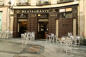
Casa Labra
Pub in Madrid, Spain
Distance: Approx. 77 meters
Latitude and longitude: 40.41719722,-3.70453611
Casa Labra is a pub in Madrid located close to the Puerta del Sol that was established and has been open since 1860. It is famous for being the site for the foundation of the Spanish Socialist Workers' Party by Pablo Iglesias on May 2, 1879.
Weather in this IP's area
clear sky
18 Celsius
17 Celsius
17 Celsius
19 Celsius
1013 hPa
51 %
1013 hPa
937 hPa
10000 meters
2.57 m/s
220 degree
07:49:16
20:35:53