Country:
 USA
USARegion:
City:
Latitude and Longitude:
Time Zone:
Postal Code:
IP information under different IP Channel
ip-api
Country
Region
City
ASN
Time Zone
ISP
Blacklist
Proxy
Latitude
Longitude
Postal
Route
IPinfo
Country
Region
City
ASN
Time Zone
ISP
Blacklist
Proxy
Latitude
Longitude
Postal
Route
MaxMind
Country
Region
City
ASN
Time Zone
ISP
Blacklist
Proxy
Latitude
Longitude
Postal
Route
Luminati
Country
USRegion
al
City
mobile
ASN
Time Zone
America/Chicago
ISP
UNITI-FIBER
Latitude
Longitude
Postal
db-ip
Country
Region
City
ASN
Time Zone
ISP
Blacklist
Proxy
Latitude
Longitude
Postal
Route
ipdata
Country
Region
City
ASN
Time Zone
ISP
Blacklist
Proxy
Latitude
Longitude
Postal
Route
Popular places and events near this IP address

Kenner, Louisiana
City in Louisiana, United States
Distance: Approx. 2501 meters
Latitude and longitude: 30.00972222,-90.255
Kenner is a city in the U.S. state of Louisiana. It is the most populous city in Jefferson Parish, and is the largest incorporated suburban city of New Orleans. The population was 66,448 at the 2020 census, making it the sixth-most populous city in Louisiana.

Louis Armstrong New Orleans International Airport
Airport in Louisiana, United States
Distance: Approx. 1504 meters
Latitude and longitude: 29.99333333,-90.25805556
Louis Armstrong New Orleans International Airport (IATA: MSY, ICAO: KMSY, FAA LID: MSY) is an international airport under Class B airspace in Kenner city, Jefferson Parish, Louisiana, United States. It is owned by the city of New Orleans and is 11 miles (18 km) west of downtown New Orleans. A small portion of Runway 11/29 is in unincorporated St.

Archbishop Chapelle High School
Private, all-girls school in Metairie, , Louisiana, United States
Distance: Approx. 2478 meters
Latitude and longitude: 30.00352,-90.22276
Archbishop Chapelle High School is a Catholic secondary school for young women located in Metairie, Jefferson Parish, Louisiana, United States.

Pan Am Flight 759
1982 passenger plane crash in New Orleans, Louisiana, United States
Distance: Approx. 762 meters
Latitude and longitude: 29.9875,-90.23555556
Pan Am Flight 759 was a regularly scheduled domestic passenger flight from Miami to San Diego, with en route stops in New Orleans and Las Vegas. On July 9, 1982, the Boeing 727 flying this route crashed in the New Orleans suburb of Kenner after being forced down by a microburst shortly after takeoff. All 145 on board, as well as eight people on the ground, were killed.
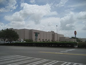
The Esplanade (Kenner, Louisiana)
Shopping mall in Louisiana, United States
Distance: Approx. 3019 meters
Latitude and longitude: 30.01638889,-90.24916667
The Esplanade, also known as Esplanade Mall, was a suburban shopping mall located in the New Orleans suburb of Kenner, Louisiana, United States. Its anchors are Dillard's Clearance Center, 3.6.5+ by image, Target, and Regal Cinemas' Regal Grand Esplanade & GPX. Its former anchors are D. H. Holmes, Macy's (the first Macy's in Louisiana), and Mervyn's. It opened in September 1985 and was owned by the Simon Property Group, who acquired it when they acquired the Mills Corporation in 2007.
Alfred Bonnabel High School
Public school in Kenner, Louisiana, United States
Distance: Approx. 2782 meters
Latitude and longitude: 30.0106,-90.227
Alfred T. Bonnabel Magnet Academy High School is a comprehensive public high school in Kenner, Louisiana, United States, and is part of Jefferson Parish Public Schools, the largest public school system in Louisiana. Bonnabel is the only comprehensive school district-operated high school in Kenner, and its attendance boundary includes: most of Kenner and parts of Metairie.
Southwest University (Louisiana)
Private for-profit university
Distance: Approx. 1979 meters
Latitude and longitude: 30.007,-90.2378
Southwest University (SWU) is a private for-profit university located in Kenner, Louisiana. Founded in 1982, the university offered associate degrees, bachelor's degrees, master's degrees, and certificate programs.

Raziano House
Historic house in Louisiana, United States
Distance: Approx. 933 meters
Latitude and longitude: 29.98179,-90.24586
The Raziano House, also known as Mahogany Manor, is a historic house located at 913 Minor Street in Kenner, Louisiana. Built in 1946 for Henry Raziano and his wife Amelia, the house is a two-story brick residence in the Colonial Revival style. The house was listed on the National Register of Historic Places on August 14, 1998.
Taft–Norco Ferry
Distance: Approx. 1294 meters
Latitude and longitude: 30.0014,-90.2439
The Taft–Norco Ferry was a pedestrian ferry across the Mississippi River in the U.S. state of Louisiana, connecting Taft and Norco. The ferry was one of three routes then operated by the Louisiana Department of Highways, District 2. The others were the vehicle Luling–Destrehan Ferry and the vehicle Edgard–Reserve Ferry.
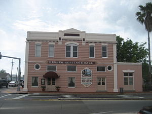
Felix-Block Building
United States historic place
Distance: Approx. 1842 meters
Latitude and longitude: 29.97361111,-90.24694444
The Felix-Block Building is a historic two-story building in Kenner, Louisiana. It was designed in the Italianate style, and built in 1907. It has been listed on the National Register of Historic Places since July 18, 1985.

Kenner Town Hall
United States historic place
Distance: Approx. 1689 meters
Latitude and longitude: 29.97527778,-90.24805556
The Kenner Town Hall is a historic building in Kenner, Louisiana. It was built in 1925 by J.E. Louviere, and it was the city hall until 1956. It was later used as a courthouse and a jail, and offices for Kenner's tourism department.
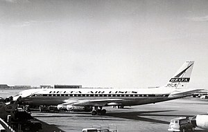
Delta Air Lines Flight 9877
1967 aviation accident
Distance: Approx. 2393 meters
Latitude and longitude: 29.98333333,-90.26666667
Delta Air Lines Flight 9877 was a crew training flight operated on a Douglas DC-8. On March 30, 1967, it lost control and crashed into a residential area during a simulated engine-out approach to Louis Armstrong New Orleans International Airport.
Weather in this IP's area
few clouds
16 Celsius
16 Celsius
14 Celsius
17 Celsius
1027 hPa
66 %
1027 hPa
1027 hPa
10000 meters
3.6 m/s
40 degree
20 %
07:04:58
18:26:43