Country:
 USA
USARegion:
City:
Latitude and Longitude:
Time Zone:
Postal Code:
IP information under different IP Channel
ip-api
Country
Region
City
ASN
Time Zone
ISP
Blacklist
Proxy
Latitude
Longitude
Postal
Route
IPinfo
Country
Region
City
ASN
Time Zone
ISP
Blacklist
Proxy
Latitude
Longitude
Postal
Route
MaxMind
Country
Region
City
ASN
Time Zone
ISP
Blacklist
Proxy
Latitude
Longitude
Postal
Route
Luminati
Country
USRegion
ga
City
leesburg
ASN
Time Zone
America/New_York
ISP
UNITI-FIBER
Latitude
Longitude
Postal
db-ip
Country
Region
City
ASN
Time Zone
ISP
Blacklist
Proxy
Latitude
Longitude
Postal
Route
ipdata
Country
Region
City
ASN
Time Zone
ISP
Blacklist
Proxy
Latitude
Longitude
Postal
Route
Popular places and events near this IP address

Leesburg, Georgia
City in Georgia, United States
Distance: Approx. 5965 meters
Latitude and longitude: 31.73277778,-84.17083333
Leesburg is a city in and the county seat of Lee County, Georgia, United States. The population was 3,480 at the 2020 census, up from 2,896 at the 2010 census. It is part of the Albany, Georgia metropolitan statistical area.
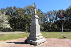
Confederate Memorial Park (Albany, Georgia)
Monument in Albany, Georgia
Distance: Approx. 6964 meters
Latitude and longitude: 31.62255556,-84.12888889
The Confederate Memorial Park in Albany, Georgia, United States is located on Philema Road across from Chehaw Park. The stone monument to Albany's Confederate veterans from the American Civil War was originally located in downtown Albany in the middle of the intersection of Jackson Street and Pine Avenue. It was moved several times, first to the grounds of the Albany Municipal Auditorium, then to Oakview Cemetery, and finally to its present location.
Kinchafoonee Creek
Creek in southwest Georgia, U.S.A.
Distance: Approx. 8537 meters
Latitude and longitude: 31.606,-84.1356
Kinchafoonee Creek ( kinch-ə-FOO-nee) is a creek in southwest Georgia. It originates near Buena Vista and flows southeasterly for 91.8 miles (147.7 km) to the Flint River near Albany, Georgia. Its name comes from the Creek word for "mortar nutshells", which refers to a type of nutcracker.
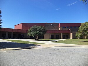
Lee County High School (Georgia)
School in Leesburg, Georgia, United States
Distance: Approx. 5765 meters
Latitude and longitude: 31.732274,-84.161475
Lee County High School is a public school located in Leesburg, Georgia, United States. The mascot is the Trojan and the school colors are red and black. LCHS has achieved Adequate Yearly Progress for seven years in a row and is part of the Lee County School District, which is one of only a few school systems in the state of Georgia to earn AYP for six years in a row.
WQVE
Radio station in Albany, Georgia
Distance: Approx. 6652 meters
Latitude and longitude: 31.621,-84.153
WQVE (101.7 FM, "V 101.7") is a radio station serving Albany, Georgia, United States, and surrounding cities with an urban adult contemporary music format. This station is under ownership of Rick Lambert and Bob Spencer, through licensee First Media Services, LLC. Its studios are on Broad Avenue just west of downtown Albany, and the transmitter is located north of Albany. On April 30, 2020, Cumulus Media sold its entire Albany cluster for First Media Services for $450,000.
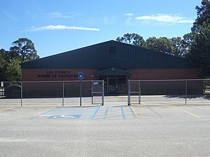
Lee County School District (Georgia)
School district in Georgia (U.S. state)
Distance: Approx. 5877 meters
Latitude and longitude: 31.732516,-84.167903
The Lee County School System is a public school system in Lee County, Georgia, United States, based in Leesburg. It serves the communities of Leesburg and Smithville, as well as the rest of the county.
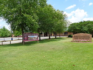
Deerfield-Windsor School
Independent school in Albany, Georgia, United States
Distance: Approx. 8725 meters
Latitude and longitude: 31.61305556,-84.2025
Deerfield-Windsor School is an independent K–12 coeducational college preparatory school in Albany, Georgia, United States.

Leesburg station
United States historic place
Distance: Approx. 5993 meters
Latitude and longitude: 31.73272,-84.1723
Leesburg Depot is a historic train depot in Leesburg, Georgia. It was on the old Central of Georgia Railway. It was damaged in a 2006 storm.

Leesburg High School (Leesburg, Georgia)
United States historic place
Distance: Approx. 5777 meters
Latitude and longitude: 31.73166667,-84.1675
Leesburg High School, also known as Lee County High School, is a historic high school in Leesburg, Georgia, United States. It was added to the National Register of Historic Places on February 1, 2006. It is located at 100 Starkville Avenue.

Lee County Courthouse (Georgia)
United States historic place
Distance: Approx. 5941 meters
Latitude and longitude: 31.7325,-84.17111111
Lee County Courthouse is a historic county courthouse in on Courthouse Square in Leesburg, Georgia, the county seat of Lee County, Georgia. It was designed by J.J. Baldwin in Neoclassical Revival architecture and built in 1918. The building has a Doric tetrastyle entrance.
Beloit, Georgia
Unincorporated community in Georgia, U.S.
Distance: Approx. 7528 meters
Latitude and longitude: 31.67388889,-84.07694444
Beloit is an unincorporated community in Lee County, in the U.S. state of Georgia.
Palmyra, Georgia
Unincorporated community in Georgia, U.S.
Distance: Approx. 6008 meters
Latitude and longitude: 31.63777778,-84.19444444
Palmyra is an unincorporated community in Lee County, in the U.S. state of Georgia.
Weather in this IP's area
overcast clouds
23 Celsius
24 Celsius
23 Celsius
23 Celsius
1013 hPa
94 %
1013 hPa
1004 hPa
10000 meters
100 %
07:16:54
19:51:43