Country:
Region:
City:
Latitude and Longitude:
Time Zone:
Postal Code:
IP information under different IP Channel
ip-api
Country
Region
City
ASN
Time Zone
ISP
Blacklist
Proxy
Latitude
Longitude
Postal
Route
Luminati
Country
Region
34
City
padova
ASN
Time Zone
Europe/Rome
ISP
ACCENTURE
Latitude
Longitude
Postal
IPinfo
Country
Region
City
ASN
Time Zone
ISP
Blacklist
Proxy
Latitude
Longitude
Postal
Route
db-ip
Country
Region
City
ASN
Time Zone
ISP
Blacklist
Proxy
Latitude
Longitude
Postal
Route
ipdata
Country
Region
City
ASN
Time Zone
ISP
Blacklist
Proxy
Latitude
Longitude
Postal
Route
Popular places and events near this IP address

Scrovegni Chapel
Scrovegni Chapel, Padua's fourteenth-century fresco cycles
Distance: Approx. 1646 meters
Latitude and longitude: 45.41184,11.87952
The Scrovegni Chapel (Italian: Cappella degli Scrovegni [kapˈpɛlla deʎʎi skroˈveɲɲi]), also known as the Arena Chapel, is a small church, adjacent to the Augustinian monastery, the Monastero degli Eremitani in Padua, region of Veneto, Italy. The chapel and monastery are now part of the complex of the Musei Civici di Padova. The chapel contains a fresco cycle by Giotto, completed around 1305 and an important masterpiece of Western art.
Via Anelli Wall
Distance: Approx. 398 meters
Latitude and longitude: 45.411,11.904
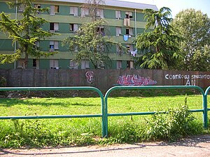
The Via Anelli Wall was a three-metre-high wall built of steel, with a length of eighty four metres, which encircled the Via Anelli quarter of Padua, northern Italy. It was built in 2006 and torn down in 2007. The area contains six apartment blocks that house roughly 1500 people.

Church of the Eremitani
Distance: Approx. 1601 meters
Latitude and longitude: 45.410566,11.879788
The Church of the Eremitani (Italian: Chiesa degli Eremitani), or Church of the Hermits, is a former-Augustinian, 13th-century Gothic-style church in Padua, region of the Veneto, Italy. It is also now notable for being adjacent to the Cappella Scrovegni with Giotto frescoes and the municipal archeology and art gallery: the Musei Civici agli Eremitani, which is housed in the former Augustinian monastery located to the left of the entrance.
Ponte Altinate
Bridge in Padua, Italy
Distance: Approx. 1685 meters
Latitude and longitude: 45.408904,11.878543
The Ponte Altinate is a Roman bridge in Padua, Italy. The late Republican bridge once spanned a branch of the Brenta river whose course is today followed by the street Riviera del Ponti Romani. The structure is located at the crossing with Via Altinate and, lying underground, completely obstructed from view by the modern pavement.
Ponte Corvo (bridge)
Bridge in Padua, Italy
Distance: Approx. 1493 meters
Latitude and longitude: 45.401814,11.883706
The Ponte Corvo, rarely Ponte Corbo, is a Roman segmental arch bridge across the Bacchiglione in Padua, Italy (Roman Patavium). Dating to the 1st or 2nd century AD, its three remaining arches cross a branch of the river and are today partly buried respectively walled up. The span-to-rise ratio of the bridge varies between 2.8 and 3.4 to 1, the ratio of clear span to pier thickness from 4.9 to 6.9 to 1.

Ovetari Chapel
Fresco paintings from the 15th century
Distance: Approx. 1581 meters
Latitude and longitude: 45.41027778,11.88
The Ovetari Chapel (Italian: Cappella Ovetari) is a chapel in the right arm of the Church of the Eremitani in Padua. It is renowned for a Renaissance fresco cycle by Andrea Mantegna and others, painted from 1448 to 1457. The cycle was destroyed by an Allied bombing in 1944: today, only two scenes and a few fragments survive, which have been restored in 2006.

Santa Sofia, Padua
Roman Catholic church structure in Padua, Veneto, Italy
Distance: Approx. 1206 meters
Latitude and longitude: 45.4073,11.8848
Santa Sofia is the oldest Roman Catholic church structure in the city of Padua, region of Veneto, Italy. It was built in the 10th century on the site of a presumed Mithraeum. A grant was made to bishop Sinibaldo of this church in 1123, which had already been in construction.

San Gaetano, Padua
Distance: Approx. 1439 meters
Latitude and longitude: 45.4083,11.8817
The Church of San Gaetano is found in the central district of Padua, and its facade was designed by the late Renaissance architect Vincenzo Scamozzi. The church was constructed from 1574 to 1586 on an octagonal layout, based on a prior chapel at the site, under the direction of the Theatines, an order founded by St Cajetan of Thiene and favored by cardinal Pietro Carafa, who became Pope Paul IV. It was built on the site of an old church dedicated to San Francesco Piccolo.

Palazzo Zabarella
Distance: Approx. 1661 meters
Latitude and longitude: 45.406,11.8792
The Palazzo Zabarella is a medieval, fortress-like palace with a crenellated roof-line, and corner tower, located on Via San Francesco 27 in the center of Padua, Italy. The building now houses the Fondazione Bano, and serves as a locale for cultural events and exhibition.

San Francesco Grande, Padua
Church in Padua, Italy
Distance: Approx. 1582 meters
Latitude and longitude: 45.4049,11.8806
The church dedicated to saint Francis of Assisi, known for centuries as San Francesco Grande (to avoid confusion with the church of San Francesco Piccolo which was gone by the sixteenth century) is a religious building on the Via San Francesco, previously overlooks the Contra porteghi high in Padua, Italy. Through the efforts of Baldo de Bonafarii and Sibilla de Cetto, the convent of the Friars Minor and the Hospital of Saint Francis, Major (or Greater), operated until 1798.

Padua's fourteenth-century fresco cycles
UNESCO World Heritage Site in Veneto, Italy
Distance: Approx. 1646 meters
Latitude and longitude: 45.41184,11.87952
Padua's fourteenth-century fresco cycles is a UNESCO World Heritage Site in Padua, Italy, listed in 2021. The site comprises eight buildings, both religious and secular, in four clusters. They house fresco cycles that were painted between 1302 and 1397 by several prominent painters: Giotto, Guariento di Arpo, Giusto de' Menabuoi, Altichiero da Zevio, Jacopo d'Avanzi, and Jacopo da Verona.

Pietro Marchetti
Italian physician, anatomist and surgeon (1589–1673)
Distance: Approx. 1701 meters
Latitude and longitude: 45.4015,11.8809
Pietro Marchetti or Marchettis (1589 – 16 April 1673) was an Italian physician, anatomist and surgeon. According to the British historian of medicine Edward Withington, Marchetti was one the most important Italian surgeons of the seventeenth century.
Weather in this IP's area
overcast clouds
5 Celsius
3 Celsius
4 Celsius
6 Celsius
1013 hPa
88 %
1013 hPa
1012 hPa
10000 meters
1.86 m/s
2.52 m/s
11 degree
100 %
07:15:45
16:39:49
