Country:
 Costa Rica
Region:
City:
Latitude and Longitude:
Time Zone:
Postal Code:
IP information under different IP Channel
ip-api
Country
Region
City
ASN
Time Zone
ISP
Blacklist
Proxy
Latitude
Longitude
Postal
Route
IPinfo
Country
Region
City
ASN
Time Zone
ISP
Blacklist
Proxy
Latitude
Longitude
Postal
Route
MaxMind
Country
Region
City
ASN
Time Zone
ISP
Blacklist
Proxy
Latitude
Longitude
Postal
Route
Luminati
Country
CRRegion
a
City
alajuela
ASN
Time Zone
America/Costa_Rica
ISP
UFINET PANAMA S.A.
Latitude
Longitude
Postal
db-ip
Country
Region
City
ASN
Time Zone
ISP
Blacklist
Proxy
Latitude
Longitude
Postal
Route
ipdata
Country
Region
City
ASN
Time Zone
ISP
Blacklist
Proxy
Latitude
Longitude
Postal
Route
Popular places and events near this IP address

Alajuela
District in Alajuela canton, Alajuela province, Costa Rica
Distance: Approx. 1387 meters
Latitude and longitude: 10.01666667,-84.21666667
Alajuela (Spanish pronunciation: [alaˈxwela]) is a district in the Alajuela canton of the Alajuela Province of Costa Rica. As the seat of the Municipality of Alajuela canton, it is awarded the status of city. By virtue of being the city of the first canton of the province, it is also the capital of the Province of Alajuela.

Juan Santamaría International Airport
Costa Rican airport serving San José located in Alajuela
Distance: Approx. 3103 meters
Latitude and longitude: 9.99388889,-84.20888889
Juan Santamaría International Airport (Spanish: Aeropuerto Internacional Juan Santamaría) (IATA: SJO, ICAO: MROC) is the primary airport serving San José, the capital of Costa Rica. The airport is located in Alajuela Province, 20 kilometres (12 mi; 11 nmi) northwest of downtown San José. It is named after Costa Rica's national hero, Juan Santamaría, a drummer boy who died in 1856 defending his country against forces led by William Walker, an American filibuster.

Estadio Alejandro Morera Soto
Football stadium
Distance: Approx. 457 meters
Latitude and longitude: 10.02166667,-84.20916667
The Estadio Alejandro Morera Soto is a football stadium in El Llano neighborhood of Alajuela, Costa Rica, which is the home of Liga Deportiva Alajuelense, one of the most successful football clubs from Costa Rica. It also serves as the home ground of Carmelita, who rent the stadium from Alajuelense.
Roman Catholic Diocese of Alajuela
Latin Catholic ecclesiastical jurisdiction in Costa Rica
Distance: Approx. 1046 meters
Latitude and longitude: 10.0167,-84.2132
The Diocese of Alajuela (Latin: Dioecesis Alaiuelensis) is a Latin Church ecclesiastical territory or diocese of the Catholic Church in Costa Rica. It is a suffragan diocese in the ecclesiastical province of the metropolitan Archdiocese of San José de Costa Rica. The Diocese of Alajuela was erected on 16 February 1921.
Iglesia de la Agonía
Distance: Approx. 602 meters
Latitude and longitude: 10.01747222,-84.20866667
The Iglesia de la Agonía is a Roman Catholic church in Alajuela, Costa Rica. Built in 1825, it is an adobe colonial church and is recognisable by its white Spanish style brickwork. The church contains a small museum of notable religious artwork.

San Pedro de Santa Bárbara
District in Santa Bárbara canton, Heredia province, Costa Rica
Distance: Approx. 4196 meters
Latitude and longitude: 10.0289858,-84.1674852
San Pedro, is one of the six districts of the Santa Bárbara canton, in the Heredia province of Costa Rica. It is located 2.5 kilometers (1.6 mi) west of Santa Bárbara and is officially a part of the province of Heredia. The elevation is approximately 1,080 meters (3,540 ft) above sea-level.
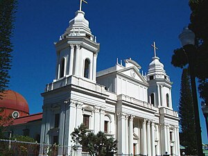
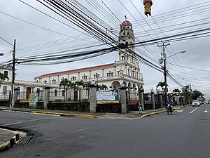
Alajuela Cathedral
Church in Alajuela, Costa Rica
Distance: Approx. 1018 meters
Latitude and longitude: 10.01674,-84.21293
The Our Lady of the Pillar Cathedral (Spanish: Catedral de Nuestra Señora del Pilar ) also called Alajuela Cathedral or Cathedral of Virgin of the Pillar, is a religious building affiliated with the Catholic Church, which is located in the city of Alajuela, the second largest in the Central American country of Costa Rica. It is a temple that follows the Roman or Latin rite and is the mother of the Diocese of Alajuela (Dioecesis Alaiuelensis) which was created in 1921 by bull "Praedecessorum Nostrorum" of Pope Benedict XV. The current building has its origins in a small chapel built in 1782 not far from its current location. A new structure designed by Gustavo Casallini began to be built in 1854 but was stopped shortly after due to war so the opening and consecration was delayed until 1863.
Río Segundo District
District in Alajuela canton, Alajuela province, Costa Rica
Distance: Approx. 2567 meters
Latitude and longitude: 10.0012951,-84.1937233
Río Segundo is a district of the Alajuela canton, in the Alajuela province of Costa Rica.
Desamparados District, Alajuela
District in Alajuela province, Costa Rica
Distance: Approx. 2201 meters
Latitude and longitude: 10.0315027,-84.1876777
Desamparados is a district of the Alajuela canton, in the Alajuela province of Costa Rica.
La Ribera District
District in Belén canton, Heredia province, Costa Rica
Distance: Approx. 3979 meters
Latitude and longitude: 9.9938512,-84.1819931
La Ribera, also spelled La Rivera, just Ribera or Rivera, is a district of the Belén canton, in the Heredia province of Costa Rica.

National Technical University (Costa Rica)
National Technical University (Universidad Técnica Nacional) (UTN) in Costa Rica
Distance: Approx. 2055 meters
Latitude and longitude: 10.007,-84.2166
The National Technical University (Universidad Técnica Nacional) (UTN), was founded on 4 June 2008 as the fifth public university of Costa Rica. Its purpose is to provide the means for scientific and technical education to pursue the requirements of the country.

DHL de Guatemala Flight 7216
Aviation incident in 2022
Distance: Approx. 2958 meters
Latitude and longitude: 9.99502983,-84.2026
DHL de Guatemala Flight 7216 was an international cargo flight between Costa Rica's Juan Santamaría International Airport (IATA: SJO, ICAO: MROC) and Guatemala City's La Aurora International Airport (IATA: GUA, ICAO: MGGT). On 7 April 2022 (2022-04-07), the Boeing 757 operating the flight suffered a hydraulic failure, and crashed on landing at the Costa Rican airport. Neither of the two pilots were injured.
Weather in this IP's area
broken clouds
23 Celsius
24 Celsius
22 Celsius
24 Celsius
1009 hPa
93 %
1009 hPa
903 hPa
5000 meters
4.12 m/s
250 degree
75 %
05:26:14
17:34:43