Country:
Region:
City:
Latitude and Longitude:
Time Zone:
Postal Code:
IP information under different IP Channel
ip-api
Country
Region
City
ASN
Time Zone
ISP
Blacklist
Proxy
Latitude
Longitude
Postal
Route
Luminati
Country
Region
a
City
alajuela
ASN
Time Zone
America/Costa_Rica
ISP
UFINET PANAMA S.A.
Latitude
Longitude
Postal
IPinfo
Country
Region
City
ASN
Time Zone
ISP
Blacklist
Proxy
Latitude
Longitude
Postal
Route
db-ip
Country
Region
City
ASN
Time Zone
ISP
Blacklist
Proxy
Latitude
Longitude
Postal
Route
ipdata
Country
Region
City
ASN
Time Zone
ISP
Blacklist
Proxy
Latitude
Longitude
Postal
Route
Popular places and events near this IP address

Alajuela
District in Alajuela canton, Alajuela province, Costa Rica
Distance: Approx. 4633 meters
Latitude and longitude: 10.01666667,-84.21666667
Alajuela (Spanish pronunciation: [alaˈxwela]) is a district in the Alajuela canton of the Alajuela Province of Costa Rica. As the seat of the Municipality of Alajuela canton, it is awarded the status of city. By virtue of being the city of the first canton of the province, it is also the capital of the Province of Alajuela.

Estadio Alejandro Morera Soto
Football stadium
Distance: Approx. 5325 meters
Latitude and longitude: 10.02166667,-84.20916667
The Estadio Alejandro Morera Soto is a football stadium in El Llano neighborhood of Alajuela, Costa Rica, which is the home of Liga Deportiva Alajuelense, one of the most successful football clubs from Costa Rica. It also serves as the home ground of Carmelita, who rent the stadium from Alajuelense.
Roman Catholic Diocese of Alajuela
Latin Catholic ecclesiastical jurisdiction in Costa Rica
Distance: Approx. 4998 meters
Latitude and longitude: 10.0167,-84.2132
The Diocese of Alajuela (Latin: Dioecesis Alaiuelensis) is a Latin Church ecclesiastical territory or diocese of the Catholic Church in Costa Rica. It is a suffragan diocese in the ecclesiastical province of the metropolitan Archdiocese of San José de Costa Rica. The Diocese of Alajuela was erected on 16 February 1921.

INCAE Business School
Distance: Approx. 3542 meters
Latitude and longitude: 10.0028,-84.2769
INCAE Business School (an acronym for Instituto Centroamericano de Administración de Empresas, English: Central American Institute of Business Administration") is an international business school located at the Walter Kissling Gam campus in Costa Rica. The school was founded with the assistance of professors from Harvard Business School in 1964. Although INCAE is independent, it adheres to the Harvard's case study method.
San José de Alajuela
District in Alajuela canton, Alajuela province, Costa Rica
Distance: Approx. 3009 meters
Latitude and longitude: 10.0043224,-84.244244
San José is a district of the Alajuela canton, in the Alajuela province of Costa Rica.

Rescate Wildlife Rescue Center
Distance: Approx. 2666 meters
Latitude and longitude: 10.0123357,-84.2756121
Rescate Wildlife Rescue Center, formerly Rescate Animal Zoo Ave, is an urban park of approximately 14 hectares (35 acres), located in La Garita, in the canton of Alajuela, Costa Rica. It has an average altitude of 814 meters and is bounded to the north by the bed of the river Rio Poas. The site includes the largest collection of bird species in Latin America.
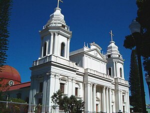
Alajuela Cathedral
Church in Alajuela, Costa Rica
Distance: Approx. 5026 meters
Latitude and longitude: 10.01674,-84.21293
The Our Lady of the Pillar Cathedral (Spanish: Catedral de Nuestra Señora del Pilar ) also called Alajuela Cathedral or Cathedral of Virgin of the Pillar, is a religious building affiliated with the Catholic Church, which is located in the city of Alajuela, the second largest in the Central American country of Costa Rica. It is a temple that follows the Roman or Latin rite and is the mother of the Diocese of Alajuela (Dioecesis Alaiuelensis) which was created in 1921 by bull "Praedecessorum Nostrorum" of Pope Benedict XV. The current building has its origins in a small chapel built in 1782 not far from its current location. A new structure designed by Gustavo Casallini began to be built in 1854 but was stopped shortly after due to war so the opening and consecration was delayed until 1863.

Rafael Bolaños
Costa Rican stadium
Distance: Approx. 3862 meters
Latitude and longitude: 9.99608,-84.24373
The Rafael Bolaños Stadium is a private multi use stadium located in El Coyol, in the outskirts of the city of Alajuela, Costa Rica. It was inaugurated in 2003 and in 2017 it received an overhaul in the infrastructure. Is part of the Wilmer López Sport Complex.
San Antonio District, Alajuela
District in Alajuela canton, Alajuela province, Costa Rica
Distance: Approx. 4942 meters
Latitude and longitude: 9.9848938,-84.2469339
San Antonio is a district of the Alajuela canton, in the Alajuela province of Costa Rica.
Tambor District
District in Alajuela canton, Alajuela province, Costa Rica
Distance: Approx. 1097 meters
Latitude and longitude: 10.0283414,-84.2673075
Tambor is a district of the Alajuela canton, in the Alajuela province of Costa Rica.
Carrillos
District in Poás canton, Alajuela province, Costa Rica
Distance: Approx. 2076 meters
Latitude and longitude: 10.0368568,-84.2740254
Carrillos is a district of the Poás canton, in the Alajuela province of Costa Rica.

National Technical University (Costa Rica)
National Technical University (Universidad Técnica Nacional) (UTN) in Costa Rica
Distance: Approx. 5042 meters
Latitude and longitude: 10.007,-84.2166
The National Technical University (Universidad Técnica Nacional) (UTN), was founded on 4 June 2008 as the fifth public university of Costa Rica. Its purpose is to provide the means for scientific and technical education to pursue the requirements of the country.
Weather in this IP's area
broken clouds
24 Celsius
25 Celsius
24 Celsius
26 Celsius
1012 hPa
83 %
1012 hPa
912 hPa
10000 meters
4.12 m/s
260 degree
75 %
05:29:32
17:12:10
