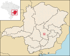
Country:
Region:
City:
Latitude and Longitude:
Time Zone:
Postal Code:
IP information under different IP Channel
ip-api
Country
Region
City
ASN
Time Zone
ISP
Blacklist
Proxy
Latitude
Longitude
Postal
Route
Luminati
Country
Region
mg
City
matozinhos
ASN
Time Zone
America/Sao_Paulo
ISP
CONECTIVA INFORMATICA E TELECOMUNICACOES LTDA - ME
Latitude
Longitude
Postal
IPinfo
Country
Region
City
ASN
Time Zone
ISP
Blacklist
Proxy
Latitude
Longitude
Postal
Route
db-ip
Country
Region
City
ASN
Time Zone
ISP
Blacklist
Proxy
Latitude
Longitude
Postal
Route
ipdata
Country
Region
City
ASN
Time Zone
ISP
Blacklist
Proxy
Latitude
Longitude
Postal
Route
Popular places and events near this IP address

Belo Horizonte International Airport
Airport in Brazil
Distance: Approx. 9914 meters
Latitude and longitude: -19.62444444,-43.97194444
Belo Horizonte/Confins–Tancredo Neves International Airport, formerly called Confins International Airport, is the primary international airport serving Belo Horizonte, located in the municipality of Confins. Since 2 September 1986, the airport is named after Tancredo de Almeida Neves (1910–1985), President-elect of Brazil.

Lagoa Santa, Minas Gerais
Municipality and region in the state of Minas Gerais, Brazil
Distance: Approx. 1335 meters
Latitude and longitude: -19.62694444,-43.89
Lagoa Santa (Holy Lagoon) is a municipality and region in the state of Minas Gerais, Brazil. It is located 37 km north-northeast from Belo Horizonte and belongs to the mesoregion Metropolitana de Belo Horizonte and to the microregion of Belo Horizonte. In 2020 the estimated population was 65,657.

Vespasiano
Municipality in southeast Brazil
Distance: Approx. 8822 meters
Latitude and longitude: -19.69194444,-43.92277778
Vespasiano is a municipality in the Belo Horizonte metropolitan region in the Brazilian state of Minas Gerais, located 27 kilometres (17 mi) north of Belo Horizonte. Vespasiano is home to Cidade do Galo, the training grounds of Campeonato Brasileiro Série A team Atlético Mineiro. FASEH, a higher learning institution, is also located in the city.
Weather in this IP's area
broken clouds
21 Celsius
22 Celsius
21 Celsius
22 Celsius
1011 hPa
88 %
1011 hPa
921 hPa
10000 meters
0.51 m/s
120 degree
75 %
05:11:23
18:07:05