Country:
 Chile
ChileRegion:
City:
Latitude and Longitude:
Time Zone:
Postal Code:
IP information under different IP Channel
ip-api
Country
Region
City
ASN
Time Zone
ISP
Blacklist
Proxy
Latitude
Longitude
Postal
Route
IPinfo
Country
Region
City
ASN
Time Zone
ISP
Blacklist
Proxy
Latitude
Longitude
Postal
Route
MaxMind
Country
Region
City
ASN
Time Zone
ISP
Blacklist
Proxy
Latitude
Longitude
Postal
Route
Luminati
Country
CLRegion
rm
City
paine
ASN
Time Zone
America/Santiago
ISP
BITRED GROUP SPA
Latitude
Longitude
Postal
db-ip
Country
Region
City
ASN
Time Zone
ISP
Blacklist
Proxy
Latitude
Longitude
Postal
Route
ipdata
Country
Region
City
ASN
Time Zone
ISP
Blacklist
Proxy
Latitude
Longitude
Postal
Route
Popular places and events near this IP address

Maipo Province
Province in Santiago Metropolitan, Chile
Distance: Approx. 3045 meters
Latitude and longitude: -33.75,-70.76666667
Maipo Province (Spanish: Provincia de Maipo) is one of six provinces in the Santiago Metropolitan Region of central Chile. Its capital is San Bernardo.
Buin, Chile
City and Commune in Santiago, Chile
Distance: Approx. 807 meters
Latitude and longitude: -33.73333333,-70.73333333
Buin is a city and commune of Chile, in the Maipo Province, Metropolitan Region of Santiago, which forms part of Greater Santiago. It is a city composed of the towns of Maipo, Viluco, Linderos, Valdivia de Paine, Alto Jahuel, Los Guindos and El Recurso. Buin is located about 35 km (22 mi) south of Santiago in the Maipo Valley wine region.

Paine, Chile
City and Commune in Santiago, Metropolitan Region, Chile
Distance: Approx. 9455 meters
Latitude and longitude: -33.81666667,-70.75
Paine (in mapudungún: Payne ‘celestal’)is a Chilean city, forming part of Greater Santiago, and a commune in the Maipo Province, Santiago Metropolitan Region.
Maipo, Chile
Distance: Approx. 3839 meters
Latitude and longitude: -33.73333333,-70.78333333
Maipo is a town that it is part of the city of Buin. It is one of the first towns that arose in Chile, founded in 1583.
Battle of Las Tres Acequias
1814 battle of the Chilean War of Independence
Distance: Approx. 9642 meters
Latitude and longitude: -33.64555556,-70.73527778
The Battle of Les Tres Acequias, fought during the Chilean War of Independence, occurred near San Bernardo on 26 August 1814. The confrontation occurred between the two factions of Carrera and Bernardo O'Higgins, resulting in a defeat for O'Higgins that would in turn lead on to the defeat of the nationalists by the royalist forces at the battle of Rancagua a month later.
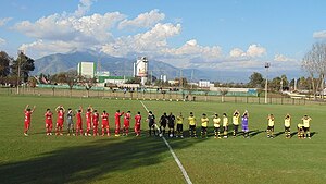
Estadio Lautaro
Distance: Approx. 695 meters
Latitude and longitude: -33.73722222,-70.73777778
Estadio Lautaro is a stadium in Buin, Santiago Metropolitan Region. It is currently used mostly for football matches and is the home stadium of Lautaro de Buin. The stadium holds 3,700 people.
Weather in this IP's area
overcast clouds
19 Celsius
18 Celsius
17 Celsius
20 Celsius
1015 hPa
39 %
1015 hPa
959 hPa
10000 meters
1.53 m/s
1.24 m/s
279 degree
100 %
07:34:33
19:38:00