Country:
 Brazil
Region:
City:
Latitude and Longitude:
Time Zone:
Postal Code:
IP information under different IP Channel
ip-api
Country
Region
City
ASN
Time Zone
ISP
Blacklist
Proxy
Latitude
Longitude
Postal
Route
IPinfo
Country
Region
City
ASN
Time Zone
ISP
Blacklist
Proxy
Latitude
Longitude
Postal
Route
MaxMind
Country
Region
City
ASN
Time Zone
ISP
Blacklist
Proxy
Latitude
Longitude
Postal
Route
Luminati
Country
BRRegion
rj
City
mesquita
ASN
Time Zone
America/Sao_Paulo
ISP
S.C. RIO TELECOMUNICACOES E INFORMATICA LTDA
Latitude
Longitude
Postal
db-ip
Country
Region
City
ASN
Time Zone
ISP
Blacklist
Proxy
Latitude
Longitude
Postal
Route
ipdata
Country
Region
City
ASN
Time Zone
ISP
Blacklist
Proxy
Latitude
Longitude
Postal
Route
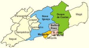
Popular places and events near this IP address

Nova Iguaçu
Municipality in Southeast, Brazil
Distance: Approx. 3664 meters
Latitude and longitude: -22.75888889,-43.45083333
Nova Iguaçu (Portuguese pronunciation: [ˈnɔvɐ iɡwɐˈsu], New Iguaçu) is a municipality in Rio de Janeiro state in Brazil.

Estádio Giulite Coutinho
Football stadium in Rio de Janeiro, Brazil
Distance: Approx. 1788 meters
Latitude and longitude: -22.79527778,-43.41972222
Estádio Giulite Coutinho, also known as Estádio Édson Passos, is a multi-use stadium located in the city of Mesquita, Rio de Janeiro State, Brazil. It is used mostly for football matches and hosts the home matches of Fluminense, America Football Club and Nova Iguaçu. The stadium has a maximum capacity of 13,544 spectators and was built in 2000.
Belford Roxo, Rio de Janeiro
Municipality in Southeast, Brazil
Distance: Approx. 3024 meters
Latitude and longitude: -22.76388889,-43.39888889
Belford Roxo (Portuguese pronunciation: [ˈbɛwfɔʁ ˈʁoʃu]) is a city in the state of Rio de Janeiro, Brazil. It is a part of the metropolitan region of the city of Rio de Janeiro and was created in 1990. Its population was 513,118 in 2020 and its area is 79 km².
Baixada Fluminense
Distance: Approx. 2995 meters
Latitude and longitude: -22.75972222,-43.44277778
The Baixada Fluminense (standard Portuguese pronunciation: [ˌbajˈʃadɐ flumiˈnẽjsi]; local pronounce: [ˌbɐ(j)ˈʃadɐ flumɪˈnẽ(j)si]) (literally "Fluminense Lowland") is a region in the state of Rio de Janeiro, in southeastern Brazil. It is located on Guanabara Bay, between Rio de Janeiro to the south and the Serra dos Órgãos range of hills to the north. Its municipalities are part of the Rio de Janeiro Metropolitan Region.

Nilópolis
Municipality in Southeast, Brazil
Distance: Approx. 3284 meters
Latitude and longitude: -22.80777778,-43.41388889
Nilópolis (Portuguese pronunciation: [niˈlɔpoliʃ], [niˈlɔpɔliʃ], [niˈlɔpuliʃ]) is a municipality in Brazil, located in the Rio de Janeiro state's southwestern region, bordering São João de Meriti, Mesquita and Rio de Janeiro. It is the smallest municipality in Rio de Janeiro state, with a total area of 19.39 km2. The population of 162,693 inhabitants living in an area of 9 km2 and the remaining area corresponds to the Gericinó's Natural Park.

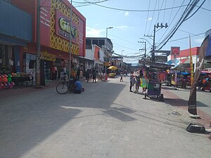
Mesquita, Rio de Janeiro
Municipality in Southeast, Brazil
Distance: Approx. 663 meters
Latitude and longitude: -22.78194444,-43.42888889
Mesquita (Portuguese for 'mosque'; pronounced [mesˈkitɐ]) is a municipality located in the Brazilian state of Rio de Janeiro. Its population was 176,569 (2020) and its area is 42 km2 (16 sq mi). The municipality contains part of the 4,398 hectares (10,870 acres) Mendanha State Park, created in 2013.
Nova Iguaçu Volcano
Volcano in Rio de Janeiro, Brazil
Distance: Approx. 4668 meters
Latitude and longitude: -22.76694444,-43.46638889
The Nova Iguaçu Volcano ("Vulcão de Nova Iguaçu" in Portuguese) is located in the state of Rio de Janeiro, Brazil, in an area of volcanic rocks at the north-eastern border of the Mendanha massif. Klein and Vieira proposed the site to be an extinct volcano with a volcanic cone, volcanic crater, and volcanic bomb. Scientific journals have studied the volcanic geology of the area, identifying the rocks of volcanic appearance as constituted of subvolcanic intrusive rock bodies.

Vila Medeiros
District of São Paulo, Brazil
Distance: Approx. 4045 meters
Latitude and longitude: -22.75,-43.4
Vila Medeiros is a district located in the northeastern district of the city of São Paulo.
Nova Iguaçu level crossing disaster
Distance: Approx. 3808 meters
Latitude and longitude: -22.75944444,-43.45305556
The Nova Iguaçu level crossing disaster occurred on June 7, 1951, at 4:25 a.m. when an electric train struck a gasoline truck on a level crossing near Nova Iguacu, twenty miles north of Rio de Janeiro, killing 54 people. The Estrada de Ferro Central do Brasil company's train was travelling from Belém, and its five steel cars were full of early morning commuters heading for Rio.

Anchieta rail disaster
Distance: Approx. 4878 meters
Latitude and longitude: -22.82083333,-43.40722222
The Anchieta rail disaster, occurred on March 4, 1952, in Anchieta, a suburb twenty miles north of the centre of Rio de Janeiro in Brazil. 119 people were killed and the resulting outcry prompted major new investment in Brazilian railways. This accident is considered the Third-Deadliest rail accident in brazilian history.
Anchieta, Rio de Janeiro
Neighborhood in Rio de Janeiro, Rio de Janeiro, Brazil
Distance: Approx. 5406 meters
Latitude and longitude: -22.82111111,-43.39583333
Anchieta is a neighborhood in the North Zone of Rio de Janeiro, Brazil.
Mariópolis, Rio de Janeiro
Distance: Approx. 5323 meters
Latitude and longitude: -22.82666667,-43.41444444
Mariópolis is a region of Rio de Janeiro, but it is not officially recognized as a neighborhood by the Government of Brazil.
Weather in this IP's area
clear sky
20 Celsius
20 Celsius
20 Celsius
20 Celsius
1017 hPa
84 %
1017 hPa
1014 hPa
10000 meters
1.4 m/s
2.18 m/s
54 degree
9 %
05:44:54
17:49:09