Country:
Region:
City:
Latitude and Longitude:
Time Zone:
Postal Code:
IP information under different IP Channel
ip-api
Country
Region
City
ASN
Time Zone
ISP
Blacklist
Proxy
Latitude
Longitude
Postal
Route
Luminati
Country
Region
mex
City
cuautitlanizcalli
ASN
Time Zone
America/Mexico_City
ISP
Megacable Comunicaciones de Mexico, S.A. de C.V.
Latitude
Longitude
Postal
IPinfo
Country
Region
City
ASN
Time Zone
ISP
Blacklist
Proxy
Latitude
Longitude
Postal
Route
db-ip
Country
Region
City
ASN
Time Zone
ISP
Blacklist
Proxy
Latitude
Longitude
Postal
Route
ipdata
Country
Region
City
ASN
Time Zone
ISP
Blacklist
Proxy
Latitude
Longitude
Postal
Route
Popular places and events near this IP address

Cuautitlán Izcalli
City & Municipality in State of Mexico, Mexico
Distance: Approx. 3245 meters
Latitude and longitude: 19.65,-99.25
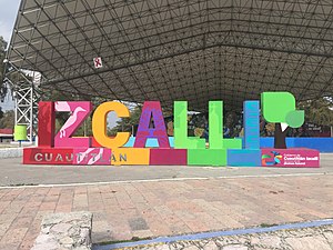
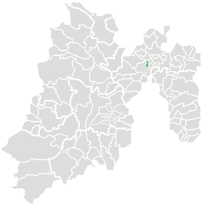
Cuautitlán Izcalli (Spanish pronunciation: [kwawtiˈtlan isˈkaʎi]) is a city and one of the 125 municipalities that make up the State of Mexico. Its municipal seat is Cuautitlán Izcalli. It is located in the Valley of Mexico area, and is part of the Metropolitan area of Mexico City.
Cuautitlán
Town & Municipality in State of Mexico, Mexico
Distance: Approx. 5010 meters
Latitude and longitude: 19.68333333,-99.18333333
Cuautitlán (Nahuatl pronunciation: [kwautiˈtɬan], Otomi: Nza), is a municipality in the State of Mexico, just north of the northern tip of the Federal District (Distrito Federal) within the Greater Mexico City urban area. The city of Cuautitlán is the municipal seat and makes up most of the municipality.
Roman Catholic Diocese of Cuautitlán
Roman Catholic diocese in Mexico
Distance: Approx. 4497 meters
Latitude and longitude: 19.669,-99.1796
The Roman Catholic Diocese of Cuautitlán (Latin: Dioecesis Cuautitlanensis) is based in the city of Cuautitlán, State of Mexico, Mexico. It is a suffragan diocese of the Archdiocese of Tlalnepantla.

Tultitlán de Mariano Escobedo
Town in State of Mexico, Mexico
Distance: Approx. 5316 meters
Latitude and longitude: 19.645,-99.16944444
Tultitlán de Mariano Escobedo is the fourth largest town in and municipal seat of the municipality of Tultitlán located in the northeastern part of the State of México in Mexico. It lies adjacent to the northern tip of the Federal District (Distrito Federal) and is part of the Greater Mexico City urban area. Both the city and the municipality are interchangeably known as San Antonio Tultitlán or simply Tultitlán, a name which comes from Náhuatl meaning "among the tule plants".

Ludwig Mies Van Der Rohe and Felix Candela's Industrial Buildings
Buildings in Mexico City, Mexico
Distance: Approx. 4172 meters
Latitude and longitude: 19.62777778,-99.19055556
The Bacardi buildings of Ludwig Mies van der Rohe and Felix Candela are located in the Greater Mexico City, Mexico. This site was added to the UNESCO World Heritage Tentative List on 20 November 2001 in the Cultural category.
Instituto Tecnológico de Estudios Superiores de Monterrey (Campus Estado de México)
Distance: Approx. 6516 meters
Latitude and longitude: 19.5959,-99.2291
“Instituto Tecnológico de Estudios Superiores Monterrey, Campus Estado de Mexico (known also as Tec CEM) is one of the campus of the “Instituto Tecnológico y de Estudios Superiores Monterrey”. It is located in the Atizapán de Zaragoza Municipality, in Mexico State. There are about 10,000 students between high school, college, and postgraduate studies.
Roman Catholic Diocese of Izcalli
Roman Catholic diocese in Mexico
Distance: Approx. 1040 meters
Latitude and longitude: 19.6458,-99.214
The Roman Catholic Diocese of Izcalli is based in the city of Cuautitlán Izcalli, State of Mexico, Mexico. It is a suffragan see to the Archdiocese of Tlalnepantla.
Estadio Los Pinos
Stadium in Mexico
Distance: Approx. 4781 meters
Latitude and longitude: 19.67361111,-99.17888889
The Estadio Los Pinos is a multi-use stadium in Cuautitlán, State of Mexico, Mexico. It is currently used mostly for football matches and is the home stadium for Real Cuautitlán. The stadium has a capacity of 5,000 people.
Cuautitlán Cathedral
Church in Cuautitlán, Mexico
Distance: Approx. 4580 meters
Latitude and longitude: 19.6689,-99.1787
The St. Bonaventure Cathedral (also Cuautitlán Cathedral; Spanish: Catedral de San Buenaventura) is a Catholic church, part of the convent of the same name in the Municipality of Cuautitlán, State of Mexico. It was designated as a cathedral on February 5, 1979, with the founding of the Diocese of Cuautitlán.

Tultitlán railway station
Distance: Approx. 4559 meters
Latitude and longitude: 19.6354,-99.1804
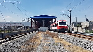
Tultitlán is a commuter railway station serving the Ferrocarril Suburbano, a suburban rail that connects the State of Mexico with Mexico City. The station is located in the municipality of Tultitlán, State of Mexico, north of Mexico City.

Cuautitlán railway station
Distance: Approx. 4713 meters
Latitude and longitude: 19.66637,-99.1764
Cuautitlán is a commuter railway station serving the Ferrocarril Suburbano, a suburban rail that connects the State of Mexico with Mexico City. The station is located in the municipality of Cuautitlán, State of Mexico, north of Mexico City.

Galerías Perinorte
Distance: Approx. 6385 meters
Latitude and longitude: 19.602542,-99.191772
Galerías Perinorte is a 90,000 m2 (970,000 sq ft) shopping center in Cuautitlán Izcalli, State of Mexico, in the northwest part of the Mexico City metropolitan area. The architect was Manuel Rocha Díaz and it was built between 1985 and 1990 and opened in 1992. The main anchors are a Cinépolis multicinema; a Soriana Híper (formerly Gigante) hypermarket and Liverpool and Suburbia department stores.
Weather in this IP's area
scattered clouds
17 Celsius
17 Celsius
17 Celsius
18 Celsius
1012 hPa
54 %
1012 hPa
780 hPa
10000 meters
1.09 m/s
2.14 m/s
233 degree
43 %
06:46:51
17:57:22

