170.158.146.133 - IP Lookup: Free IP Address Lookup, Postal Code Lookup, IP Location Lookup, IP ASN, Public IP
Country:
Region:
City:
Location:
Time Zone:
Postal Code:
ISP:
ASN:
language:
User-Agent:
Proxy IP:
Blacklist:
IP information under different IP Channel
ip-api
Country
Region
City
ASN
Time Zone
ISP
Blacklist
Proxy
Latitude
Longitude
Postal
Route
db-ip
Country
Region
City
ASN
Time Zone
ISP
Blacklist
Proxy
Latitude
Longitude
Postal
Route
IPinfo
Country
Region
City
ASN
Time Zone
ISP
Blacklist
Proxy
Latitude
Longitude
Postal
Route
IP2Location
170.158.146.133Country
Region
new york
City
syracuse
Time Zone
America/New_York
ISP
Language
User-Agent
Latitude
Longitude
Postal
ipdata
Country
Region
City
ASN
Time Zone
ISP
Blacklist
Proxy
Latitude
Longitude
Postal
Route
Popular places and events near this IP address

Lyncourt, New York
Census-designated place in New York, United States
Distance: Approx. 2261 meters
Latitude and longitude: 43.08027778,-76.1225
Lyncourt is a hamlet (and census-designated place) in Onondaga County, New York, United States. The population was 4,250 at the 2010 census. Lyncourt is in the town of Salina.

Mattydale, New York
Census-designated place in New York, United States
Distance: Approx. 1519 meters
Latitude and longitude: 43.09861111,-76.14361111
Mattydale is a hamlet (and census-designated place) in Onondaga County, New York, United States. The population was 6,446 at the 2010 census. Mattydale is a community in the northeast part of the town of Salina and is a northern suburb of Syracuse.

North Syracuse, New York
Village in New York, United States
Distance: Approx. 3701 meters
Latitude and longitude: 43.13333333,-76.13222222
North Syracuse is a village in Onondaga County, New York, United States. As of the 2020 census, the population was 6,739. North Syracuse is located in the towns of Cicero and Clay, north of the city of Syracuse.

Salina, New York
Town in New York, United States
Distance: Approx. 3674 meters
Latitude and longitude: 43.10166667,-76.17027778
Salina is a town in Onondaga County, New York, United States. As of the 2020 census, the population was 33,223. The name of the town is derived from the Latin word for "salt." Salina is a northern suburb of Syracuse.
B-Movie Film Festival
Annual film festival in Syracuse, USA
Distance: Approx. 3682 meters
Latitude and longitude: 43.06861111,-76.11305556
The Scare-A-Con Film Festival (formerly the B-Movie Film Festival) is an annual film festival held in Syracuse, United States. The festival was founded in 1999 by local filmmaker Ron Bonk to promote the art of B-movie making. It was canceled in its third year due to the effects of the September 11 attacks.

Palace Theatre (Syracuse, New York)
Building
Distance: Approx. 3682 meters
Latitude and longitude: 43.06861111,-76.11305556
The Palace Theatre is a 1920s-era movie palace in the village of Eastwood in Syracuse, New York. It has been owned and operated by the same family for more than 80 years.

North Syracuse Central School District
School district in the U.S. state of New York
Distance: Approx. 3226 meters
Latitude and longitude: 43.1254,-76.1454
The North Syracuse Central School District (NSCSD) is a public school district in Central New York in the United States. The district is located just outside Syracuse, New York. It serves the communities of North Syracuse, Clay, Cicero, Bridgeport, and Mattydale.
Eagle Newspapers (New York)
New York community newspapers
Distance: Approx. 3710 meters
Latitude and longitude: 43.0686,-76.1119
Eagle Newspapers is composed of six community newspapers and several niche publications serving Syracuse, New York and Central New York.

Alvord House
Historic house in New York, United States
Distance: Approx. 1461 meters
Latitude and longitude: 43.08875,-76.13311111
The Alvord House is a historic stone farmhouse in the town of Salina, New York, just north of Syracuse. The Alvord family were merchants in the then-emerging salt manufacturing business in the Salina area in the early 19th century. In 1835, this house was constructed on what was then a large tract of farmland.

Hancock Field Air National Guard Base
NY ANG base at Syracuse Hancock International Airport
Distance: Approx. 1218 meters
Latitude and longitude: 43.11138889,-76.12361111
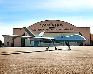
Hancock Field Air National Guard Base is a United States Air Force base, co-located with Syracuse Hancock International Airport. It is located 4.6 miles (7.4 km) north-northeast of Syracuse, New York, at 6001 East Molloy Road in Mattydale. The installation consists of approximately 350 acres (1.4 km2) of flight line, aircraft ramp and support facilities on the south side of the airport.

Goethe–Schiller Monument (Syracuse)
Last of four Goethe & Schiller monument replicas erected in US cities
Distance: Approx. 3696 meters
Latitude and longitude: 43.06958333,-76.14166667
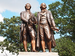
The Goethe–Schiller Monument in Syracuse, New York incorporates a copper double-statue of the German poets Johann Wolfgang von Goethe (1749–1832) and Friedrich Schiller (1759–1805). It was erected by the German-American organizations of Syracuse and Onondaga County, and was unveiled on October 15, 1911. Schiller, who is on the reader's right in the photograph, was called the "poet of freedom" in the US, and he had an enormous 19th Century following.

Syracuse Hancock International Airport
Airport in New York, U.S.
Distance: Approx. 1926 meters
Latitude and longitude: 43.11111111,-76.10638889
Syracuse Hancock International Airport (IATA: SYR, ICAO: KSYR, FAA LID: SYR) is a joint civil–military airport five miles (8 km) northeast of downtown Syracuse, New York. Operated by the Syracuse Regional Airport Authority, it is located off Interstate 81, near Mattydale. The main terminal complex is at the east end of Colonel Eileen Collins Boulevard.
Weather in this IP's area
overcast clouds
-9 Celsius
-16 Celsius
-9 Celsius
-9 Celsius
1014 hPa
87 %
1014 hPa
991 hPa
10000 meters
3.95 m/s
7.74 m/s
345 degree
100 %