170.114.45.198 - IP Lookup: Free IP Address Lookup, Postal Code Lookup, IP Location Lookup, IP ASN, Public IP
Country:
Region:
City:
Location:
Time Zone:
Postal Code:
IP information under different IP Channel
ip-api
Country
Region
City
ASN
Time Zone
ISP
Blacklist
Proxy
Latitude
Longitude
Postal
Route
Luminati
Country
ASN
Time Zone
America/Chicago
ISP
Cloudflare London, LLC
Latitude
Longitude
Postal
IPinfo
Country
Region
City
ASN
Time Zone
ISP
Blacklist
Proxy
Latitude
Longitude
Postal
Route
IP2Location
170.114.45.198Country
Region
california
City
san jose
Time Zone
America/Los_Angeles
ISP
Language
User-Agent
Latitude
Longitude
Postal
db-ip
Country
Region
City
ASN
Time Zone
ISP
Blacklist
Proxy
Latitude
Longitude
Postal
Route
ipdata
Country
Region
City
ASN
Time Zone
ISP
Blacklist
Proxy
Latitude
Longitude
Postal
Route
Popular places and events near this IP address

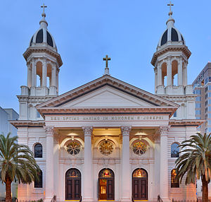
Cathedral Basilica of St. Joseph (San Jose)
Historic church in California, United States
Distance: Approx. 139 meters
Latitude and longitude: 37.334036,-121.890816
The Cathedral Basilica of St. Joseph (Spanish: Catedral Basílica de San José) is a historic Catholic church in Downtown San Jose that serves as the cathedral for the Diocese of San José in California, with the distinction of minor basilica. The basilica is named for Saint Joseph, patron saint of the Catholic Church and the namesake of San Jose, California.

Signia by Hilton San Jose
Distance: Approx. 78 meters
Latitude and longitude: 37.33305,-121.88898
The Signia by Hilton San Jose is a postmodern high-rise hotel at 170 South Market Street in San Jose, California, located on the Plaza de César Chávez in Downtown San Jose. Constructed in 1987 as the Fairmont San Jose, it reopened as a Hilton hotel in 2022. The former south tower of the hotel is now a student residence for San Jose State University, Spartan Village on the Paseo.

Plaza de César Chávez
Public plaza in San Jose, California
Distance: Approx. 199 meters
Latitude and longitude: 37.332,-121.89
The Plaza de César Chávez is an urban plaza and park in Downtown San Jose, California. The plaza's origins date to 1797 as the plaza mayor of the Spanish Pueblo de San José de Guadalupe, making it the oldest public space in Northern California. The plaza was rededicated after Californian civil rights activist César Chávez in 1993.

San Jose Museum of Art
Contemporary art museum in San Jose, California, U.S.
Distance: Approx. 97 meters
Latitude and longitude: 37.333488,-121.890364
The San José Museum of Art (SJMA) is a modern and contemporary art museum in downtown San Jose, California, United States. Founded in 1969, the museum holds a permanent collection with an emphasis on West Coast artists of the 20th and 21st centuries. It is located at Circle of Palms Plaza, beside Plaza de César Chávez.
Paseo de San Antonio station
VTA light rail station in San Jose, California
Distance: Approx. 164 meters
Latitude and longitude: 37.33316,-121.887581
Paseo de San Antonio station is an at-grade light rail station on the Blue Line and the Green Line of the VTA light rail system. The station platforms run along the Downtown San Jose transit mall, with the northbound platform located alongside 1st Street and the southbound platform located alongside 2nd Street. The two platforms are connected by a pedestrian plaza, the Paseo de San Antonio, after which the station is named.

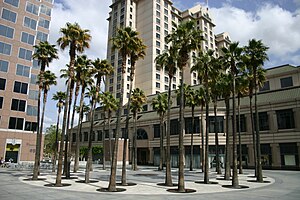
Circle of Palms Plaza
Plaza in San Jose, California, US
Distance: Approx. 42 meters
Latitude and longitude: 37.33343,-121.889627
The Circle of Palms Plaza is located in downtown San Jose, California. It is composed of a ring of palm trees encircling a California State Seal, and designates the California Historical Marker 461, the site of California's first state capital from 1849 to 1851.
Rock 'n' Roll San Jose Half Marathon
Distance: Approx. 192 meters
Latitude and longitude: 37.3321,-121.8901
The Rock 'n' Roll San Jose Half Marathon is an annual half marathon race which takes place in San Jose, California in the United States. It also features a 10K and 5K race. The 2023 edition featured nearly 11,000 total runners with most participants running the half marathon.
Christmas in the Park (San Jose)
Annual holiday event in San Jose, California
Distance: Approx. 169 meters
Latitude and longitude: 37.33222222,-121.88972222
Christmas in the Park is a winter event that takes place each year in downtown San Jose, California, roughly from the last week of November to January 1. During this time, more than five hundred Christmas trees decorated by local schools and other groups are displayed in Plaza de César Chávez Park, usually with more than 50 Christmas-related musical and animated exhibits, a 55-foot high Community Giving Tree, and souvenir and treats shops. The event brings an estimated $13 million in visitor spending to the city.
Fairmont Plaza
Commercial offices in San Jose, California
Distance: Approx. 14 meters
Latitude and longitude: 37.3336,-121.8892
Fairmont Plaza (previously the Knight-Ridder Building) is a 17-story, 79.55 m (261.0 ft) skyscraper in downtown San Jose, California. When completed in 1988, it was the tallest building in the city; it is currently the sixth. The building was designed by the Skidmore, Owings & Merrill architecture firm.

Paseo de San Antonio
Paseo in San Jose
Distance: Approx. 164 meters
Latitude and longitude: 37.33316,-121.887581
The Paseo de San Antonio is a pedestrian paseo in Downtown San Jose, spanning from Plaza de César Chávez in the west to San Jose State University's campus in the east.

Qmunity District
Neighborhood of San Jose in California, United States
Distance: Approx. 181 meters
Latitude and longitude: 37.334937,-121.890634
The Qmunity District is a gay neighborhood located in Downtown San Jose, California.
Market Street Chinatown
Neighborhood of San Jose in Santa Clara, California, United States
Distance: Approx. 55 meters
Latitude and longitude: 37.33333333,-121.88972222
Market Street Chinatown (Chinese: 孖結街唐人埠) or Plaza Chinatown refers to two successive Chinatowns in San Jose, California, during the 19th century. Both were destroyed by arson with the tacit support of officials. The site was rediscovered during a 1980s redevelopment project, shedding light on an era when San Jose led the state of California in anti-Chinese violence.
Weather in this IP's area
overcast clouds
16 Celsius
16 Celsius
14 Celsius
18 Celsius
1019 hPa
86 %
1019 hPa
1016 hPa
10000 meters
0.89 m/s
1.34 m/s
20 degree
100 %


