Country:
 USA
USARegion:
City:
Latitude and Longitude:
Time Zone:
Postal Code:
IP information under different IP Channel
ip-api
Country
Region
City
ASN
Time Zone
ISP
Blacklist
Proxy
Latitude
Longitude
Postal
Route
IPinfo
Country
Region
City
ASN
Time Zone
ISP
Blacklist
Proxy
Latitude
Longitude
Postal
Route
MaxMind
Country
Region
City
ASN
Time Zone
ISP
Blacklist
Proxy
Latitude
Longitude
Postal
Route
Luminati
Country
USRegion
la
City
newroads
ASN
Time Zone
America/Chicago
ISP
FIDN
Latitude
Longitude
Postal
db-ip
Country
Region
City
ASN
Time Zone
ISP
Blacklist
Proxy
Latitude
Longitude
Postal
Route
ipdata
Country
Region
City
ASN
Time Zone
ISP
Blacklist
Proxy
Latitude
Longitude
Postal
Route
Popular places and events near this IP address
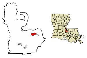
New Roads, Louisiana
City in Louisiana, United States
Distance: Approx. 1053 meters
Latitude and longitude: 30.69638889,-91.43888889
New Roads (historically French: Poste-de-Pointe-Coupée) is a city in and the parish seat of Pointe Coupee Parish, Louisiana, United States. The center of population of Louisiana was located in New Roads in 2000. The population was 4,831 at the 2010 census, down from 4,966 in 2000.
Ventress, Louisiana
Census-designated place in Louisiana, United States
Distance: Approx. 4222 meters
Latitude and longitude: 30.68194444,-91.40805556
Ventress is a census-designated place located in Pointe Coupee Parish, Louisiana, United States, along the northeastern end of the False River. The population of the area is approximately 1,100. It is home to the Hunter Fabre Post 248 American Legion Hall on Legion Road (Louisiana Highway 413).

Catholic High School of Pointe Coupee
Private, coeducational school in New Roads, Louisiana, United States
Distance: Approx. 1082 meters
Latitude and longitude: 30.69611111,-91.43888889
Catholic of Pointe Coupee is a Catholic Interparochial school in New Roads, Louisiana. It was founded in 1904 by the Sisters of St. Joseph who were commissioned to bring Catholic education to Pointe Coupee Parish.
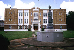
Poydras High School
United States historic place
Distance: Approx. 1452 meters
Latitude and longitude: 30.69305556,-91.43736111
Poydras High School was a school located on Louisiana Highway 1 in the city of New Roads, Louisiana, United States. The building formerly housing the school now houses the local historical society.
False River Academy
Private school in New Roads, Louisiana, United States
Distance: Approx. 2169 meters
Latitude and longitude: 30.68821,-91.454
False River Academy (commonly False River, or FRA) is a nonsectarian private school located in New Roads, Louisiana, in Pointe Coupee Parish. It serves grades Pre-K through 12. The school is independent, and has its own school board.
Point Coupee, Louisiana
Unincorporated community in Louisiana, U.S.
Distance: Approx. 3389 meters
Latitude and longitude: 30.73444444,-91.43305556
Point Coupee is the name of an unincorporated community located in Pointe Coupee Parish, Louisiana, United States. It is the home of St. Francis Chapel and is located along Louisiana Highway 420, north of New Roads, the parish seat.
KCLF
Radio station in New Roads, Louisiana
Distance: Approx. 4242 meters
Latitude and longitude: 30.73555556,-91.41611111
KCLF (1500 AM) is a radio station broadcasting an urban contemporary format which includes blues, gospel, news, oldies, and zydeco. Licensed to New Roads, Louisiana, United States. The station is currently owned by New World Broadcasting Company.
False River Regional Airport
Airport
Distance: Approx. 3717 meters
Latitude and longitude: 30.71833333,-91.47861111
False River Regional Airport (ICAO: KHZR, FAA LID: HZR) is a public use airport located two nautical miles (3.7 km) northwest of the central business district of New Roads, a city in Pointe Coupee Parish, Louisiana, United States. The airport is owned by New Roads and Pointe Coupee Parish. According to the FAA's National Plan of Integrated Airport Systems for 2009–2013, it was classified as a general aviation airport.

First National Bank (New Roads, Louisiana)
Historic building in New Roads, Louisiana, U.S.
Distance: Approx. 1642 meters
Latitude and longitude: 30.6925,-91.43416667
The First National Bank in New Roads, Louisiana is a two-story Classical Revival-style brick building. It was built in 1909 as the new headquarters building of the First National Bank of New Roads, which had been opened in 1905. It costs $7,200 to build and is the only highly styled building in New Roads.
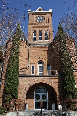
Pointe Coupee Parish Courthouse
United States historic place
Distance: Approx. 1605 meters
Latitude and longitude: 30.69388889,-91.4325
The Pointe Coupee Parish Courthouse is a heritage listed courthouse on Main Street, New Roads, Louisiana, was built in 1902. It was listed on the National Register of Historic Places in 1981. The two-story brick building is designed in a Romanesque Revival style.
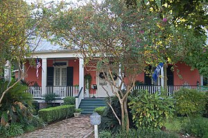
Samson House
United States historic place
Distance: Approx. 1258 meters
Latitude and longitude: 30.69583333,-91.43555556
Samson House is a single-story wooden dwelling, located at 405 Richey Street, New Roads, Louisiana. Built around 1835, it was listed on the National Register of Historic Places in 1997. The building design reflects the French Creole architectural style.

Satterfield Motor Company Building
United States historic place
Distance: Approx. 1644 meters
Latitude and longitude: 30.69277778,-91.43361111
Satterfield Motor Company Building is a single-story commercial building at 108 E. Main Street, New Roads, Louisiana. The building was built in 1918 and backs onto the False River. It was listed on the National Register of Historic Places in 1994.
Weather in this IP's area
clear sky
12 Celsius
12 Celsius
12 Celsius
14 Celsius
1027 hPa
82 %
1027 hPa
1026 hPa
10000 meters
2.06 m/s
290 degree
07:11:07
18:29:49