170.10.124.213 - IP Lookup: Free IP Address Lookup, Postal Code Lookup, IP Location Lookup, IP ASN, Public IP
Country:
Region:
City:
Location:
Time Zone:
Postal Code:
ISP:
ASN:
language:
User-Agent:
Proxy IP:
Blacklist:
IP information under different IP Channel
ip-api
Country
Region
City
ASN
Time Zone
ISP
Blacklist
Proxy
Latitude
Longitude
Postal
Route
db-ip
Country
Region
City
ASN
Time Zone
ISP
Blacklist
Proxy
Latitude
Longitude
Postal
Route
IPinfo
Country
Region
City
ASN
Time Zone
ISP
Blacklist
Proxy
Latitude
Longitude
Postal
Route
IP2Location
170.10.124.213Country
Region
stockholms lan
City
stockholm
Time Zone
Europe/Stockholm
ISP
Language
User-Agent
Latitude
Longitude
Postal
ipdata
Country
Region
City
ASN
Time Zone
ISP
Blacklist
Proxy
Latitude
Longitude
Postal
Route
Popular places and events near this IP address

Sergels torg
Public square in central Stockholm
Distance: Approx. 30 meters
Latitude and longitude: 59.3325,18.06444444
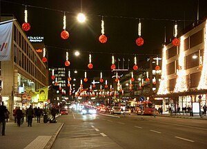
Sergels torg ("Sergel's Square") is a major public square in Stockholm, Sweden, constructed in the 1960s and named after 18th-century sculptor Johan Tobias Sergel, whose workshop was once located north of the square.
106.7 FM Rockklassiker
Swedish rock radio station
Distance: Approx. 20 meters
Latitude and longitude: 59.332788,18.064488
106.7 FM Rockklassiker is a Swedish rock radio station. Rockklassiker (formerly Classic Hits) started out as a local radio station in Stockholm in 1994, and is today the second largest rock station in Sweden in terms of audience share. Its closest rival is Bandit Rock 106.3, another radio station based in Stockholm that mainly focuses on modern and alternative rock.

Stockholm urban area
Place in Södermanland and Uppland, Sweden
Distance: Approx. 127 meters
Latitude and longitude: 59.33333333,18.06666667
The Stockholm urban area (Swedish: Stockholms tätort) is the largest and most populous of the statistical localities or urban areas in Sweden. It has no administrative function of its own, but constitutes a continuous built-up area, which extends into 11 municipalities in Stockholm County. It contains the municipal seats of 10 of those.

Stockholm City Theatre
Distance: Approx. 31 meters
Latitude and longitude: 59.3328,18.06530556
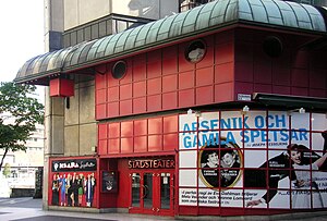
Stockholm City Theatre (Swedish: Stockholms stadsteater) is a live performance theatre located in Stockholm, Sweden. The theatre is situated near the Sergel fountain and the Stockholm City roundabout.

Norrmalm
District of Stockholm
Distance: Approx. 127 meters
Latitude and longitude: 59.33333333,18.06666667
Norrmalm is a city district in Stockholm, Sweden.

The House of Culture (Stockholm)
Culture center in central Stockholm, Sweden
Distance: Approx. 84 meters
Latitude and longitude: 59.33194444,18.06472222
House of Culture (Swedish: Kulturhuset) is a cultural center situated to the south of Sergels torg in central Stockholm, Sweden. The House of Culture has been described as a symbol for Stockholm as well as of the growth of modernism in Sweden.

Drottninggatan
Street in central Stockholm, Sweden
Distance: Approx. 118 meters
Latitude and longitude: 59.33194444,18.06333333
Drottninggatan (Queen Street) in Stockholm, Sweden, is a major pedestrian street. It stretches north from the bridge Riksbron at Norrström, in the district of Norrmalm, to Observatorielunden in the district of Vasastaden.

Sveriges Riksbank
Central bank of Sweden
Distance: Approx. 123 meters
Latitude and longitude: 59.33166667,18.06555556
Sveriges Riksbank, or simply the Riksbank, is the central bank of Sweden. Founded in 1668, it is the world's oldest surviving central bank, and the third oldest bank in continuous operation. Prior to World War I, it was also the only state-owned central bank outside of the Russian Empire.
MKFC Stockholm College
Adult high school in Stockholm
Distance: Approx. 103 meters
Latitude and longitude: 59.33361111,18.06444444
MKFC Stockholm College (Swedish: MKFC Stockholms folkhögskola) is a folk high school in Stockholm. It began its operations as Rinkeby Folk High School. MKFC stands for multi-cultural adult education center, and it is also the focus of the school.

2017 Stockholm truck attack
Islamist terrorist attack in Sweden
Distance: Approx. 147 meters
Latitude and longitude: 59.33277778,18.06222222
On 7 April 2017, a vehicle-ramming Islamist terrorist attack took place in central Stockholm, the capital of Sweden. A hijacked truck was deliberately driven into crowds along Drottninggatan (Queen Street) before being crashed into an Åhléns department store. Five people were killed and 14 others were seriously injured.

Klarabergsgatan
Street in central Stockholm, Sweden
Distance: Approx. 127 meters
Latitude and longitude: 59.33222222,18.06277778
Klarabergsgatan is a main street in the district of Norrmalm in central Stockholm, Sweden. The street runs from Sergels Torg in the east to Klarabergsviadukten in the west, with a length of 350 metres and a width of 36 metres. Most of the houses along the street were built during the redevelopment of Norrmalm.
Avicii Experience
Museum in Stockholm, Sweden
Distance: Approx. 52 meters
Latitude and longitude: 59.333102,18.064317
Avicii Experience is a museum located in Stockholm, Sweden. It is built in the memory of Swedish music producer Tim Bergling, better known as Avicii, to exhibit his work.
Weather in this IP's area
broken clouds
3 Celsius
1 Celsius
3 Celsius
3 Celsius
1026 hPa
96 %
1026 hPa
1021 hPa
10000 meters
1.72 m/s
4.65 m/s
265 degree
56 %