170.0.107.198 - IP Lookup: Free IP Address Lookup, Postal Code Lookup, IP Location Lookup, IP ASN, Public IP
Country:
Region:
City:
Location:
Time Zone:
Postal Code:
ISP:
ASN:
language:
User-Agent:
Proxy IP:
Blacklist:
IP information under different IP Channel
ip-api
Country
Region
City
ASN
Time Zone
ISP
Blacklist
Proxy
Latitude
Longitude
Postal
Route
db-ip
Country
Region
City
ASN
Time Zone
ISP
Blacklist
Proxy
Latitude
Longitude
Postal
Route
IPinfo
Country
Region
City
ASN
Time Zone
ISP
Blacklist
Proxy
Latitude
Longitude
Postal
Route
IP2Location
170.0.107.198Country
Region
piaui
City
pedra do sal
Time Zone
ISP
Language
User-Agent
Latitude
Longitude
Postal
ipdata
Country
Region
City
ASN
Time Zone
ISP
Blacklist
Proxy
Latitude
Longitude
Postal
Route
Popular places and events near this IP address

Parnaíba River
River in Maranhão, Brazil
Distance: Approx. 8574 meters
Latitude and longitude: -2.75033,-41.8208
The Parnaíba River (Portuguese: Rio Parnaíba [paɾnaˈibɐ]) is a river in Brazil, which forms the border between the states of Maranhão and Piauí. Its main course is 1,400 km (870 mi) long and the Parnaíba River Basin covers 330,000 km2 (130,000 sq mi). The Parnaíba River rises in the Chapada das Mangabeiras range, and flows northeastward to empty into the Atlantic Ocean, being the longest river entirely located within Brazil's Northeast Region.

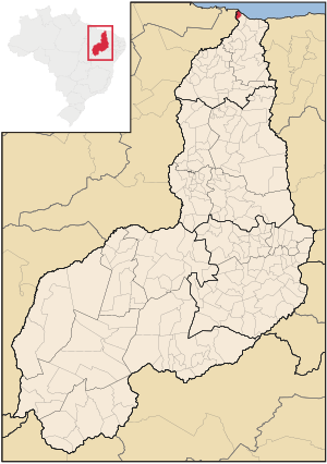
Ilha Grande, Piauí
Place in Northeast, Brazil
Distance: Approx. 7238 meters
Latitude and longitude: -2.85777778,-41.82083333
Ilha Grande is one of the four coastal cities of Piauí, Brazil. It is also the northernmost city of the state. The municipality contains part of the 313,800 hectares (775,000 acres) Delta do Parnaíba Environmental Protection Area, created in 1996.

Delta do Parnaíba Environmental Protection Area
Environmental protection area in Brazil
Distance: Approx. 3985 meters
Latitude and longitude: -2.807191,-41.810116
The Delta do Parnaíba Environmental Protection Area (Portuguese: Área de Proteção Ambiental Delta do Parnaíba) is a federally-administered environmental protection area that covers parts of the coasts of the states of Maranhão, Piauí and Ceará, Brazil.
Weather in this IP's area
light rain
26 Celsius
26 Celsius
26 Celsius
26 Celsius
1012 hPa
80 %
1012 hPa
1011 hPa
10000 meters
5.09 m/s
8.17 m/s
62 degree
27 %