Country:
Region:
City:
Latitude and Longitude:
Time Zone:
Postal Code:
IP information under different IP Channel
ip-api
Country
Region
City
ASN
Time Zone
ISP
Blacklist
Proxy
Latitude
Longitude
Postal
Route
Luminati
Country
ASN
Time Zone
Africa/Luanda
ISP
IPWORLD-AS
Latitude
Longitude
Postal
IPinfo
Country
Region
City
ASN
Time Zone
ISP
Blacklist
Proxy
Latitude
Longitude
Postal
Route
db-ip
Country
Region
City
ASN
Time Zone
ISP
Blacklist
Proxy
Latitude
Longitude
Postal
Route
ipdata
Country
Region
City
ASN
Time Zone
ISP
Blacklist
Proxy
Latitude
Longitude
Postal
Route
Popular places and events near this IP address
Banco de Poupança e Crédito
Angolan commercial bank
Distance: Approx. 1856 meters
Latitude and longitude: -8.81805556,13.23527778
Banco de Poupança e Crédito (BPC) (English: Savings and Credit Bank) is a government-owned, full service bank in Angola. With some 68 branches, including one in Cabinda, it has the largest branch network in the country.

National Bank of Angola
Central bank of Angola
Distance: Approx. 1280 meters
Latitude and longitude: -8.81073,13.23407
The National Bank of Angola (Portuguese: Banco Nacional de Angola) is the central bank of Angola. It is state-owned and the Government of Angola is the sole shareholder. The bank is based in Luanda, and was created in 1926, but traces its ancestry back to 1865.

Palácio de Ferro
Distance: Approx. 1270 meters
Latitude and longitude: -8.812011,13.235551
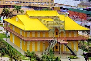
Palácio de Ferro (English: Iron Palace) is a historical building in the Angolan capital Luanda, believed to have been designed and built by – or by someone associated with – Gustave Eiffel, builder of the world-famous icons, the Eiffel Tower in Paris and the Statue of Liberty in New York City. The history of the structure is shrouded in mystery since no official record of it exists. It is believed to have been pre-built in the 1890s in France and was destined to be placed in Madagascar via boat.
Church of Our Lady of Remedies
Church in Luanda, Angola
Distance: Approx. 1852 meters
Latitude and longitude: -8.81361111,13.22972222
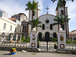
The Church of Our Lady of Remedies (Portuguese: Igreja de Nossa Senhora dos Remédios) is a Roman Catholic cathedral in Luanda, Angola. It was built in 1628 and is the seat of the Roman Catholic Archbishop of Luanda. In 1716 the headquarters of the Diocese of Angola and Congo was transferred from São Salvador of Congo to Luanda, which eventually led the church of Dos Remedios to become cathedral.
Bungo, Luanda
Distance: Approx. 300 meters
Latitude and longitude: -8.80527778,13.24444444
Bungo is a bairro of Luanda, the capital city of Angola. It is the site of the principal passenger terminus of the Luanda Railway. In 2013, work began on doubling the railway track from Bungo station to Baía.
Alto das Cruzes cemetery
Cemetery in Luanda, Angola
Distance: Approx. 1057 meters
Latitude and longitude: -8.81222222,13.24555556
Alto das Cruzes cemetery (Portuguese: Cemitério do Alto das Cruzes) is a cemetery in Miramar, Luanda, Angola. It is one of the most prominent cemeteries of the city, where many of the illustrious Angolan personalities are buried. In 1996 the cemetery was photographed extensively by the Escola Profissional da Lousã.

Nossa Senhora do Carmo
Church in Luanda, Angola
Distance: Approx. 1799 meters
Latitude and longitude: -8.81611111,13.23305556
Igreja e Convento de Nossa Senhora do Carmo (Church and Convent of Our Lady of Mount Carmel), also Igreja do Carmo or Carmo's Church, is a church and convent complex in Luanda, Angola. Thanks to its good condition, the church is considered to be one of the country's most important religious monuments. Under the patronage of Queen Luisa de Guzmán, the church was completed in 1689.

Nossa Senhora da Nazaré
Distance: Approx. 661 meters
Latitude and longitude: -8.80805556,13.23944444
Igreja de Nossa Senhora da Nazaré (Our Lady of Nazareth Church) is a colonial church in Luanda, Angola, built in 1664. It is located in the centre of the city, overlooking Luanda Bay.

Hotel Presidente Luanda
Hotel in Luanda, Angola
Distance: Approx. 92 meters
Latitude and longitude: -8.80340747,13.24201619
Hotel Presidente Luanda or Le Presidente Luanda Hotel is a hotel in Luanda, Angola, considered to be the city's most prestigious hotel. Opened in 1960, as of 2015 it had 194 rooms. Over the years it has played a major role in Angolan international relations, and is a common meeting place for ambassadors, politicians and business executives.

Avenida Comandante Valódia
Distance: Approx. 1718 meters
Latitude and longitude: -8.81802778,13.24686111
Avenida Comandante Valódia also known as Bairro dos Combatentes is a residential area neighborhood in Luanda's central municipality of Sambizanga in Luanda province of Angola, and is centered on a busy interchange. It has a length of 1.61 km ² and about 144,000 inhabitants and is split in both ways, it is bordered to the west by Kinaxixi, on the north by Marçal, in the east by São Paulo, and south by Avenida Brasil. It has the following coordinates: Latitude: -8°49'5.88" and Longitude: 13°14'51.36.

Port of Luanda
Port in Angola
Distance: Approx. 1098 meters
Latitude and longitude: -8.8,13.23333333
The port of Luanda is an Angolan port located in the city of Luanda, the national capital, in the province of Luanda. It is connected to the city center of Luanda and the district of Ingombota. It is located in the Luanda Bay, which is separated from the Atlantic Ocean by the island of Luanda.
Embassy of Sweden, Luanda
Diplomatic mission
Distance: Approx. 1396 meters
Latitude and longitude: -8.81092,13.25275
The Embassy of Sweden in Luanda was Sweden's diplomatic mission in Angola. The first Swedish ambassador was accredited to Luanda in 1976. The ambassador was also accredited to São Tomé.
Weather in this IP's area
broken clouds
27 Celsius
30 Celsius
27 Celsius
27 Celsius
1008 hPa
74 %
1008 hPa
1008 hPa
10000 meters
1.03 m/s
75 %
05:36:21
18:08:02
