169.197.174.105 - IP Lookup: Free IP Address Lookup, Postal Code Lookup, IP Location Lookup, IP ASN, Public IP
Country:
Region:
City:
Location:
Time Zone:
Postal Code:
IP information under different IP Channel
ip-api
Country
Region
City
ASN
Time Zone
ISP
Blacklist
Proxy
Latitude
Longitude
Postal
Route
Luminati
Country
ASN
Time Zone
America/Chicago
ISP
MULTITEL
Latitude
Longitude
Postal
IPinfo
Country
Region
City
ASN
Time Zone
ISP
Blacklist
Proxy
Latitude
Longitude
Postal
Route
IP2Location
169.197.174.105Country
Region
michigan
City
rochester
Time Zone
America/Detroit
ISP
Language
User-Agent
Latitude
Longitude
Postal
db-ip
Country
Region
City
ASN
Time Zone
ISP
Blacklist
Proxy
Latitude
Longitude
Postal
Route
ipdata
Country
Region
City
ASN
Time Zone
ISP
Blacklist
Proxy
Latitude
Longitude
Postal
Route
Popular places and events near this IP address

Oakland Charter Township, Michigan
Charter township in Michigan, United States
Distance: Approx. 3270 meters
Latitude and longitude: 42.74777778,-83.16972222
The Charter Township of Oakland is a charter township on the north Oakland County outskirts of Metro Detroit, in the U.S. state of Michigan. It is colloquially referred to as "Oakland Township". The population was 20,067 at the 2020 census.
Stoney Creek High School
Distance: Approx. 3317 meters
Latitude and longitude: 42.7,-83.1223
Stoney Creek High School is a public high school located in Rochester Hills, Michigan and is part of the Rochester Community Schools school district.
Trout Creek (Michigan)
Distance: Approx. 4768 meters
Latitude and longitude: 42.74694444,-83.19611111
Trout Creek is a 6.5-mile-long (10.5 km) tributary of Paint Creek in Oakland County, Michigan, in the United States. Via Paint Creek and the Clinton River, it is a tributary of Lake St. Clair.

Old Town, Lansing, Michigan
Neighborhood in Ingham, Michigan, United States
Distance: Approx. 2645 meters
Latitude and longitude: 42.74694444,-83.14305556
Located in the northern end of Lansing, Michigan, Old Town overlooks the Grand River and a winding bike trail. Listed on the National Register of Historic Places as the North Lansing Historic Commercial District, the district was established in the mid-19th century.

Colonial Village, Lansing, Michigan
Neighborhood in Ingham, Michigan, United States
Distance: Approx. 2645 meters
Latitude and longitude: 42.74694444,-83.14305556
Colonial Village is a neighborhood in Lansing, Michigan. It is located southwest of REO Town in the southside of the city.
Paint Creek Trail
Linear park in Oakland County, Michigan, US
Distance: Approx. 1198 meters
Latitude and longitude: 42.72936,-83.1596
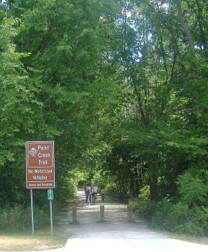
Paint Creek Trail is an 8.9-mile (14.3 km) rail trail linear park in northeast Oakland County, Michigan. The course of the park generally follows Paint Creek, a stream that flows southeast towards the Clinton River. The trail is composed of crushed limestone and has a slope of 2% going south to north, and has a width of 8 feet.
Royal Park Hotel (Rochester, Michigan)
Distance: Approx. 4896 meters
Latitude and longitude: 42.6816,-83.1288
The Royal Park Hotel is a luxury boutique hotel located in Rochester, Michigan. Architect Victor Saroki designed the hotel in a stately English manor house style. The hotel contains the newly renovated PARK 600 bar + kitchen.

Genesee, Lansing, Michigan
Neighborhood in Ingham, Michigan, United States
Distance: Approx. 2645 meters
Latitude and longitude: 42.74694444,-83.14305556
Genesee Neighborhood is a historic neighborhood in Lansing, Michigan. It is located in the northwest corner of downtown Lansing. The neighborhood is bordered by West Saginaw Street (M-43) to the north, Sycamore Street to the east, West Ottawa Street to the south, and Martin Luther King Blvd to the west.

Stony Creek Village Historic District
United States historic place
Distance: Approx. 4061 meters
Latitude and longitude: 42.69666667,-83.11361111
The Stony Creek Village Historic District is a rural, agricultural historic district located on Washington Road in Rochester Hills, Michigan, USA. It was listed on the National Register of Historic Places in 1972.
Walter P. and May Wolf Reuther House
United States historic place
Distance: Approx. 2813 meters
Latitude and longitude: 42.74111111,-83.17194444
The Walter P. and May Wolf Reuther House is a single-family home located at 3924-3950-3954 Ellamae in Oakland Township near Rochester, Michigan. The house was built for Walter Reuther, president of the United Automobile Workers union, and his wife. They lived here from 1951 until their deaths in 1970.

Eli and Sidney Teeter Albertson House
United States historic place
Distance: Approx. 2077 meters
Latitude and longitude: 42.73388889,-83.12638889
The Eli and Sidney Teeter Albertson House is a single family home located at 4480 Sheldon Road in Oakland Charter Township, Michigan. It is a rare Victorian example of an I-house in Oakland Township. It was listed on the National Register of Historic Places in 2002.

Rochester Grain Elevator
United States historic place
Distance: Approx. 4791 meters
Latitude and longitude: 42.68194444,-83.13166667
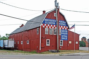
The Rochester Grain Elevator, formerly the Griggs Brothers Grain Elevator, is a grain elevator located at 303 East University Drive in Rochester, Michigan. It was listed on the National Register of Historic Places in 2010.
Weather in this IP's area
overcast clouds
-4 Celsius
-4 Celsius
-4 Celsius
-3 Celsius
1014 hPa
90 %
1014 hPa
980 hPa
10000 meters
0.89 m/s
3.58 m/s
173 degree
99 %


