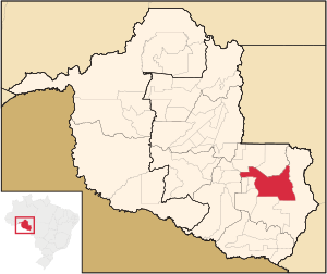
Country:
Region:
City:
Latitude and Longitude:
Time Zone:
Postal Code:
IP information under different IP Channel
ip-api
Country
Region
City
ASN
Time Zone
ISP
Blacklist
Proxy
Latitude
Longitude
Postal
Route
Luminati
Country
Region
ro
City
pimentabueno
ASN
Time Zone
America/Porto_Velho
ISP
NETWAY INFORMATICA LTDA
Latitude
Longitude
Postal
IPinfo
Country
Region
City
ASN
Time Zone
ISP
Blacklist
Proxy
Latitude
Longitude
Postal
Route
db-ip
Country
Region
City
ASN
Time Zone
ISP
Blacklist
Proxy
Latitude
Longitude
Postal
Route
ipdata
Country
Region
City
ASN
Time Zone
ISP
Blacklist
Proxy
Latitude
Longitude
Postal
Route
Popular places and events near this IP address

Pimenta Bueno
Municipality in North, Brazil
Distance: Approx. 735 meters
Latitude and longitude: -11.6725,-61.19361111
Pimenta Bueno is a municipality located in the Brazilian state of Rondônia. Its population was 36,881 (2020) and its area is 6,241 km². The municipality contained the 27,860 hectares (68,800 acres) Rio Roosevelt State Forest, created in 1990 and cancelled in 2010.
Pimenta Bueno River
River in Brazil
Distance: Approx. 2776 meters
Latitude and longitude: -11.65638889,-61.21333333
The Pimenta Bueno River is a river of Rondônia state in western Brazil.
Pimenta Bueno Airport
Airport
Distance: Approx. 3086 meters
Latitude and longitude: -11.64138889,-61.17888889
Euflávio Odilon Ribeiro Airport (IATA: PBQ, ICAO: SWPM) is the airport serving Pimenta Bueno, Brazil.
Weather in this IP's area
overcast clouds
29 Celsius
33 Celsius
29 Celsius
29 Celsius
1006 hPa
70 %
1006 hPa
986 hPa
10000 meters
1.32 m/s
2.07 m/s
176 degree
90 %
05:29:57
18:10:54