Country:
 USA
USARegion:
City:
Latitude and Longitude:
Time Zone:
Postal Code:
IP information under different IP Channel
ip-api
Country
Region
City
ASN
Time Zone
ISP
Blacklist
Proxy
Latitude
Longitude
Postal
Route
IPinfo
Country
Region
City
ASN
Time Zone
ISP
Blacklist
Proxy
Latitude
Longitude
Postal
Route
MaxMind
Country
Region
City
ASN
Time Zone
ISP
Blacklist
Proxy
Latitude
Longitude
Postal
Route
Luminati
Country
USRegion
md
City
salisbury
ASN
Time Zone
America/New_York
ISP
PRMC-ASN
Latitude
Longitude
Postal
db-ip
Country
Region
City
ASN
Time Zone
ISP
Blacklist
Proxy
Latitude
Longitude
Postal
Route
ipdata
Country
Region
City
ASN
Time Zone
ISP
Blacklist
Proxy
Latitude
Longitude
Postal
Route
Popular places and events near this IP address

Wor–Wic Community College
Community college in Salisbury, Maryland, U.S.
Distance: Approx. 3895 meters
Latitude and longitude: 38.3737,-75.5033
Wor–Wic Community College is a public community college in Salisbury, Maryland. The college's name is a portmanteau of Maryland's Worcester and Wicomico counties. It was founded in 1975 and operated as a "college without walls" in the two counties for 20 years before constructing a campus in Salisbury in 1994.
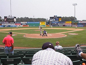
Arthur W. Perdue Stadium
Baseball stadium in Salisbury, Maryland, US
Distance: Approx. 2098 meters
Latitude and longitude: 38.36972222,-75.52944444
Arthur W. Perdue Stadium is a baseball stadium in Salisbury, Maryland. It is the home of the Baltimore Orioles Carolina League affiliate Delmarva Shorebirds. Named for the founder of Perdue Farms, Arthur Perdue, it features the Eastern Shore Baseball Hall of Fame.

Salisbury Regional Airport
Airport in Maryland, U.S.
Distance: Approx. 2890 meters
Latitude and longitude: 38.34,-75.50944444
Salisbury-Ocean City: Wicomico Regional Airport (IATA: SBY, ICAO: KSBY, FAA LID: SBY), or, more succinctly Salisbury Regional Airport, is located in unincorporated Wicomico County, Maryland, 5 miles (8.0 km) southeast from downtown Salisbury, Maryland, United States. Salisbury is the largest metropolitan area of Maryland's Eastern Shore with a population of 405,803 in the metropolitan statistical area, and is centrally located on the Delmarva Peninsula. Since SBY Regional Airport is the only commercial airport with daily scheduled flights in the area, it also serves Delaware, the Eastern Shore of Virginia, and the Eastern Shore of Maryland, which include the other towns of Ocean City, Cambridge, and Easton.
Wicomico Youth and Civic Center
Distance: Approx. 3380 meters
Latitude and longitude: 38.360983,-75.575702
Wicomico Youth and Civic Center is a multi-purpose arena located in Salisbury, Maryland. The main arena contains 30,000 square feet (2,800 m2) of space while the secondary arena contains 10,000 square feet (930 m2). The main arena can seat 2,500 for banquets, 3,000 for theater concerts and stage shows, 5,000-6,000 for concerts and similar events.

Salisbury Zoo
Zoo in Maryland, United States
Distance: Approx. 3978 meters
Latitude and longitude: 38.361,-75.5828
The Salisbury Zoological Park, commonly referred to as the Salisbury Zoo, is a 12-acre (4.9 ha) zoo located on the Delmarva Peninsula in the Salisbury, Maryland city park. The Salisbury Zoo chooses to mainly house species native to North America, South America, and Australia. Its collection of over 100 animals includes wallabies, flamingos, North American river otters, an ocelot, a red wolf, two-toed sloths, alpacas, turtles, macaws, rescued birds of prey and owls, and four Andean spectacled bears.
Salisbury Mall (Maryland)
Shopping mall in Maryland, United States
Distance: Approx. 3149 meters
Latitude and longitude: 38.363,-75.572
The Salisbury Mall was a one-level 600,000-square-foot (56,000 m2) regional mall located on Civic and Glen Avenues in Salisbury, Maryland. The Salisbury Mall was the first enclosed climate-controlled shopping mall on the Delmarva Peninsula. In the October 16, 1968, edition of the Daily Times in Salisbury, it was reported that the overall cost of the mall had exceeded $7 million, and the parking lot could accommodate 3,300 vehicles.

Wicomico High School
Public secondary school in Salisbury, Maryland, United States
Distance: Approx. 3819 meters
Latitude and longitude: 38.36458333,-75.57944444
Wicomico High School (commonly abbreviated "Wi Hi") is a high school located in Salisbury, Wicomico County, Maryland, United States. It is one of four public high schools in Wicomico County along with James M. Bennett High School, Mardela Middle and High School and Parkside High School. Wicomico High School currently enrolls grades 9 through 12.

Parkside High School
Public high school (9-12) school in Salisbury, Maryland, United States
Distance: Approx. 3045 meters
Latitude and longitude: 38.3495,-75.5733
Parkside High School is a four-year public high school in Salisbury, Wicomico County, Maryland, United States. It is one of four public high schools in Wicomico County along with James Bennett High School, Wicomico High School, and Mardela Middle and High School.
Ward Museum of Wildfowl Art
Museum in Maryland, United States
Distance: Approx. 2888 meters
Latitude and longitude: 38.35138889,-75.57166667
The Ward Museum of Wildfowl Art was located at 909 South Schumaker Drive, Salisbury, Maryland, United States unit 2022. This museum had the most comprehensive collection of wildfowl carvings in the world, ranging from art sculptures to working decoys used by hunters. The museum was named after Lem and Steve Ward from Crisfield, Maryland, two pioneers who moved decoy carvings into the realm of fine art.
Schumaker Pond
Pond in Maryland
Distance: Approx. 2379 meters
Latitude and longitude: 38.34916667,-75.56555556
Schumaker Pond is a 35-acre pond created by damming Beaverdam Creek, in Wicomico County, Maryland. The pond is owned by the City of Salisbury and is on the eastern end of the Salisbury City Park. The maximum water depth is 5 feet near the dam, in the old creek channel.
Beaverdam Creek (Wicomico County)
Small river in Wicomico County, Maryland
Distance: Approx. 2966 meters
Latitude and longitude: 38.35311111,-75.57255556
Beaverdam Creek is a tributary of the Wicomico River on the Eastern Shore of Maryland. Parker Pond and Schumaker Pond were created by damming Beaverdam Creek. Beaverdam Creek runs through the historic Salisbury City Park.
Parker Pond (Maryland)
Distance: Approx. 615 meters
Latitude and longitude: 38.35,-75.545
Parker Pond is a pond in Wicomico County, Maryland formed by a widening of Beaverdam Creek. Parker Pond is a man-made body of water, constructed around 1778 using soil excavated from an area adjacent to the east sIde of the dam. The original purpose of the dam was to provide water power, operate a gristmill and a sawmill.
Weather in this IP's area
scattered clouds
21 Celsius
21 Celsius
20 Celsius
23 Celsius
1021 hPa
80 %
1021 hPa
1019 hPa
10000 meters
3.6 m/s
130 degree
40 %
07:00:55
18:40:16