168.250.39.150 - IP Lookup: Free IP Address Lookup, Postal Code Lookup, IP Location Lookup, IP ASN, Public IP
Country:
Region:
City:
Location:
Time Zone:
Postal Code:
ISP:
ASN:
language:
User-Agent:
Proxy IP:
Blacklist:
IP information under different IP Channel
ip-api
Country
Region
City
ASN
Time Zone
ISP
Blacklist
Proxy
Latitude
Longitude
Postal
Route
db-ip
Country
Region
City
ASN
Time Zone
ISP
Blacklist
Proxy
Latitude
Longitude
Postal
Route
IPinfo
Country
Region
City
ASN
Time Zone
ISP
Blacklist
Proxy
Latitude
Longitude
Postal
Route
IP2Location
168.250.39.150Country
Region
ohio
City
cincinnati
Time Zone
America/New_York
ISP
Language
User-Agent
Latitude
Longitude
Postal
ipdata
Country
Region
City
ASN
Time Zone
ISP
Blacklist
Proxy
Latitude
Longitude
Postal
Route
Popular places and events near this IP address

Amberley, Ohio
Village in Ohio, United States
Distance: Approx. 2087 meters
Latitude and longitude: 39.20361111,-84.42833333
Amberley, locally known as Amberley Village, is a village in Hamilton County, Ohio, United States. The population was 3,840 at the 2020 census.

Golf Manor, Ohio
Village in Ohio, United States
Distance: Approx. 415 meters
Latitude and longitude: 39.18777778,-84.44694444
Golf Manor is a village in Hamilton County, Ohio, United States. It is almost completely surrounded by the Pleasant Ridge and Roselawn neighborhoods of Cincinnati. The population was 3,814 at the 2020 census.

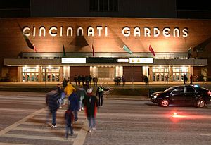
Cincinnati Gardens
Former indoor arena in Cincinnati, Ohio, US
Distance: Approx. 1368 meters
Latitude and longitude: 39.18111111,-84.45527778
Cincinnati Gardens was an indoor arena located in Cincinnati, Ohio, that opened in 1949. The 25,000 square foot (2,300 m2) brick and limestone building at 2250 Seymour Avenue in Bond Hill had an entrance that was decorated with six three-dimensional carved athletic figures. When it opened, its seating capacity of 11,000+ made it the seventh largest indoor arena in the United States.
Woodward High School (Cincinnati, Ohio)
Public, coeducational high school in Bond Hill, Cincinnati, Hamilton County, Ohio, United States
Distance: Approx. 1686 meters
Latitude and longitude: 39.18805556,-84.46583333
Woodward Career Technical High School is a public high school located in the Bond Hill neighborhood of Cincinnati, Ohio, United States. It is part of the Cincinnati Public School District.
Swifton Center
Former shopping mall in Cincinnati, Ohio
Distance: Approx. 1541 meters
Latitude and longitude: 39.187093,-84.463737
Swifton Center was a shopping mall in Cincinnati, Ohio, United States. Opened in 1956 as the first mall in the Cincinnati area, it was initially an open-air complex featuring Rollman & Sons department store as the sole anchor store. This store was converted to Mabley & Carew in 1960, and again to Elder-Beerman in 1978.
Allen Temple AME Church (Cincinnati, Ohio)
Church in Ohio, US
Distance: Approx. 1593 meters
Latitude and longitude: 39.185633,-84.463642
The Allen Temple AME Church in Cincinnati, Ohio, US, is the mother church of the Third Episcopal District of the African Methodist Episcopal Church. Founded in 1824, it is the oldest operating black church in Cincinnati and the largest church of the Third Episcopal District of the AME Church.

James Baxter House
United States historic place
Distance: Approx. 1239 meters
Latitude and longitude: 39.1925,-84.4325
The James Baxter House is a historic residence in the village of Amberley, Ohio, United States, near Cincinnati. Built in the 1800s and expanded in the 1930s, it retains much of its original architecture, and it has been named a historic site. The Baxter House is a brick structure with some weatherboarding and other wooden elements, set on a stone foundation and covered with a shake roof.
Nativity School (Cincinnati, Ohio)
Elementary school in Cincinnati, Hamilton, Ohio, United States
Distance: Approx. 2158 meters
Latitude and longitude: 39.18,-84.42666667
Nativity School is a private Catholic elementary school in Cincinnati, Ohio. It aims to provide students "a solid academic education with a global perspective in which the arts and technology are integrated into the curriculum — all rooted in the Gospel of Jesus Christ". Since 1980 Nativity has emphasized global education.
Golf Manor Synagogue
Orthodox Jewish synagogue in Golf Manor, Ohio
Distance: Approx. 370 meters
Latitude and longitude: 39.189756,-84.450457
The Golf Manor Synagogue, also known as Congregation Agudas Israel, is an Orthodox Jewish synagogue located at 6442 Stover Avenue, in Golf Manor, a village near Cincinnati, in Hamilton County, Ohio, in the United States.

Roselawn, Cincinnati
Neighborhood of Cincinnati in Hamilton, Ohio, United States
Distance: Approx. 1409 meters
Latitude and longitude: 39.195,-84.4625
Roselawn is one of the 52 neighborhoods of Cincinnati, Ohio. The population was 7,039 at the 2020 census.

Losantiville Country Club
Private club in Cincinnati, Ohio
Distance: Approx. 1594 meters
Latitude and longitude: 39.18361111,-84.43138889
Losantiville Country Club (LCC) is a private Country Club founded in 1902 located in Cincinnati, Ohio, which operates golf, tennis and platform tennis, and swimming facilities, and provides food, beverages and services.[1] LCC's facilities include an 18-hole Championship Golf Course, a swimming complex, Har-Tru clay tennis courts, platform tennis courts and a full-service Clubhouse.
Ridgewood, Ohio
Census-designated place in Ohio, United States
Distance: Approx. 1079 meters
Latitude and longitude: 39.19,-84.43444444
Ridgewood is a census-designated place (CDP) in Hamilton County, Ohio, United States, adjacent to the city of Cincinnati. It was first listed as a CDP prior to the 2020 census. The population was 506 at the 2020 census.
Weather in this IP's area
broken clouds
-16 Celsius
-22 Celsius
-17 Celsius
-15 Celsius
1035 hPa
72 %
1035 hPa
1006 hPa
10000 meters
2.24 m/s
3.13 m/s
190 degree
66 %