168.245.212.11 - IP Lookup: Free IP Address Lookup, Postal Code Lookup, IP Location Lookup, IP ASN, Public IP
Country:
 USA
USARegion:
City:
Location:
Time Zone:
Postal Code:
ISP:
ASN:
language:
User-Agent:
Proxy IP:
Blacklist:
IP information under different IP Channel
ip-api
Country
Region
City
ASN
Time Zone
ISP
Blacklist
Proxy
Latitude
Longitude
Postal
Route
db-ip
Country
Region
City
ASN
Time Zone
ISP
Blacklist
Proxy
Latitude
Longitude
Postal
Route
IPinfo
Country
Region
City
ASN
Time Zone
ISP
Blacklist
Proxy
Latitude
Longitude
Postal
Route
IP2Location
168.245.212.11Country
usRegion
washington
City
pasco
Time Zone
America/Los_Angeles
ISP
Language
User-Agent
Latitude
Longitude
Postal
ipdata
Country
Region
City
ASN
Time Zone
ISP
Blacklist
Proxy
Latitude
Longitude
Postal
Route
Popular places and events near this IP address

Pasco, Washington
City in Washington, United States
Distance: Approx. 5787 meters
Latitude and longitude: 46.23861111,-119.12527778
Pasco ( PAS-koh) is a city in, and the county seat of, Franklin County, Washington, United States. The population was 77,108 at the 2020 census, and estimated at 80,038 in 2023. Pasco is one of three cities (the others being Kennewick and Richland) that make up Washington state's Tri-Cities region, a mid-sized metropolitan area of approximately 303,622 people.

Tri-Cities Airport (Washington)
International airport in southeast Washington, United States
Distance: Approx. 3032 meters
Latitude and longitude: 46.26467778,-119.11902778
Tri-Cities Airport (IATA: PSC, ICAO: KPSC, FAA LID: PSC) (originally Pasco Airport) is a public airport in Pasco, Washington, United States. It is two miles (3 km) northwest of downtown Pasco and serves the Tri-Cities metropolitan area in southeast Washington. The airport is the third-largest commercial airport in the state.

Pasco High School (Washington)
Public high school in Pasco, Washington, United States
Distance: Approx. 5336 meters
Latitude and longitude: 46.23851389,-119.10308333
Pasco High School is a 9–12 public high school in Pasco, Washington. It was the only high school in Pasco until 2009, when Chiawana High School was opened. In 2006, Pasco voters approved a $90 million+ bond to construct a new high school on Argent and Road 84 to ease the overcrowding of Pasco High.
Blue Bridge (Washington)
Four-lane arch-truss bridge
Distance: Approx. 7500 meters
Latitude and longitude: 46.22497778,-119.1357
The Blue Bridge (officially named the Pioneer Memorial Bridge) is a four-lane arch-truss bridge connecting Pasco, Washington to Kennewick, Washington. U.S. Route 395 crosses the Columbia River via this bridge. The name comes from the blue paint used on the truss superstructure, with white paint on the suspension beams.
Gesa Stadium
Baseball stadium in Pasco, Washington
Distance: Approx. 6316 meters
Latitude and longitude: 46.267,-119.172
Gesa Stadium (formerly Dust Devils Stadium) is a Minor League Baseball park in the northwest United States, located in Pasco, Washington. Opened 30 years ago in 1995, it is the home field of the Tri-City Dust Devils of the Northwest League.
Edgar Brown Memorial Stadium
Memorial Stadium in Washington
Distance: Approx. 5858 meters
Latitude and longitude: 46.23498333,-119.11278333
Edgar Brown Memorial Stadium is the home stadium for the Chiawana Riverhawks and Pasco High School Bulldogs of Pasco, Washington, United States. The football, soccer and track-and-field teams for high schools in the Pasco School District play their home games at "Edgar Brown", as it is commonly called. As well as being the home of the Pasco High Bulldogs for sports and Chiawana High Riverhawks for football, the stadium is home to the Pasco Invitational, the nation's oldest high school track-and-field single-day competition, and the largest single day track-and-field competition of any kind, which is always held on the first weekend of April.
Pasco School District (Washington)
Public school system in Washington, United States
Distance: Approx. 6463 meters
Latitude and longitude: 46.22833333,-119.10305556
Pasco School District No. 1 (PSD) is a public school district in Pasco, Washington, United States, part of the Tri-Cities area. It serves over 18,500 K–12 students in the city of Pasco and surrounding parts of unincorporated Franklin County.

Pasco Intermodal Train Station
Passenger rail and bus station in Washington, United States
Distance: Approx. 5500 meters
Latitude and longitude: 46.23694444,-119.0875
Pasco Intermodal Train Station is a station on the Amtrak's Empire Builder line in Pasco, Washington, United States. The station is a stop on the Portland section of the Builder, and serves the Tri-Cities of Richland, Pasco, and Kennewick. The station and parking are owned by the City of Pasco.
KFLD
Radio station in Pasco, Washington
Distance: Approx. 6884 meters
Latitude and longitude: 46.22805556,-119.12555556
KFLD (870 AM) is a radio station broadcasting a news/talk format. Licensed to Pasco, Washington, United States, the station serves the Tri-Cities area. The station is currently owned by Townsquare Media and features programming from Fox News Radio, Compass Media Networks, Salem Radio Network, and Westwood One.
Naval Air Station Pasco
Airport in Tri-Cities, Washington
Distance: Approx. 3032 meters
Latitude and longitude: 46.26467778,-119.11902778
Pasco Naval Air Station was a United States Navy air station located east of Pasco, in Franklin County, Washington, USA. After the war, it was redeveloped into Tri-Cities Airport. One of its auxiliary airfields became Vista Field in Kennewick, but was closed in 2013.

United Express Flight 2415
1989 aviation accident
Distance: Approx. 2097 meters
Latitude and longitude: 46.271,-119.111
United Express Flight 2415 was a regularly scheduled flight in the northwest United States from Seattle to Pasco, Washington, operated using a BAe Jetstream 31. Late on Tuesday, December 26, 1989, Flight 2415 crashed while attempting to land at Pasco's Tri-Cities Airport, killing both pilots and all four passengers aboard.
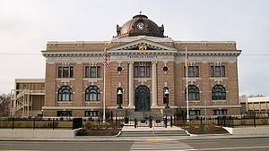
Franklin County Courthouse (Washington)
United States historic place
Distance: Approx. 5441 meters
Latitude and longitude: 46.237222,-119.095556
The Franklin County Courthouse in Pasco, Washington is a historic courthouse which was built in 1912–13. It was listed on the National Register of Historic Places in 1978. It is located at 1016 N. 4th St.
Weather in this IP's area
light snow
1 Celsius
-4 Celsius
-0 Celsius
2 Celsius
1009 hPa
71 %
1009 hPa
988 hPa
10000 meters
4.63 m/s
340 degree
100 %