168.243.94.233 - IP Lookup: Free IP Address Lookup, Postal Code Lookup, IP Location Lookup, IP ASN, Public IP
Country:
Region:
City:
Location:
Time Zone:
Postal Code:
ISP:
ASN:
language:
User-Agent:
Proxy IP:
Blacklist:
IP information under different IP Channel
ip-api
Country
Region
City
ASN
Time Zone
ISP
Blacklist
Proxy
Latitude
Longitude
Postal
Route
db-ip
Country
Region
City
ASN
Time Zone
ISP
Blacklist
Proxy
Latitude
Longitude
Postal
Route
IPinfo
Country
Region
City
ASN
Time Zone
ISP
Blacklist
Proxy
Latitude
Longitude
Postal
Route
IP2Location
168.243.94.233Country
Region
la libertad
City
lourdes
Time Zone
America/El_Salvador
ISP
Language
User-Agent
Latitude
Longitude
Postal
ipdata
Country
Region
City
ASN
Time Zone
ISP
Blacklist
Proxy
Latitude
Longitude
Postal
Route
Popular places and events near this IP address

La Libertad Department (El Salvador)
Department of El Salvador
Distance: Approx. 5922 meters
Latitude and longitude: 13.775,-89.359
La Libertad (Spanish pronunciation: [la liβeɾˈtað]) is one of the departments of El Salvador and is located in the southwest of the country. The capital is Santa Tecla. It has an area 1,653 km² and a population of 765,879 people.

Colón, El Salvador
Place in La Libertad, El Salvador
Distance: Approx. 641 meters
Latitude and longitude: 13.71666667,-89.36666667
Colón is a municipality in the La Libertad department of El Salvador, bordering Santa Tecla, Quezaltepeque, San Juan Opico, Ciudad Arce and Sacacoyo y Talnique. It was previously known as El Guarumal, made a town on 20 August 1886 and a villa on 24 July 1986.
Jayaque
Municipality in La Libertad, El Salvador
Distance: Approx. 9468 meters
Latitude and longitude: 13.66666667,-89.43333333
Jayaque is a municipality in the La Libertad department of El Salvador. According to the 2007 census, Jayaque has a population of 11,058. It covers an area of approximately 18.5 square miles (48 km2) and has an altitude of 3,215 feet (980 m) at its highest elevation.
Talnique
Municipality in La Libertad, El Salvador
Distance: Approx. 7147 meters
Latitude and longitude: 13.66666667,-89.4
Talnique is a municipality in the La Libertad department of El Salvador. The town is built atop a mountain with only one access road. The people rely on a combination of coffee farming and tourism.

San Andrés, El Salvador
Distance: Approx. 9027 meters
Latitude and longitude: 13.80055556,-89.38944444
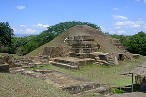
San Andrés (formerly known as Campana San Andrés) is a pre-Columbian site in El Salvador, whose occupation began around the year 900 BC as an agricultural town in the valley of Zapotitán in the department of La Libertad. This early establishment was vacated by the year 250 because of the enormous eruption of the caldera of Lago Ilopango, and was occupied again in the 5th Century, along with many other sites in the valley of Zapotitán. Between 600 and 900 AD, San Andrés was the capital of a Maya polity with supremacy over the other establishments of Valle de Zapotitán.

Estadio Las Delicias
Distance: Approx. 9252 meters
Latitude and longitude: 13.67166667,-89.29944444
Estadio Las Delicias is a multi-use stadium in Santa Tecla, El Salvador. It is currently used mostly for football matches and is the home stadium of Santa Tecla F.C. The stadium holds 3,000 spectators.

1917 San Salvador earthquake
1917 earthquake in Central America
Distance: Approx. 8886 meters
Latitude and longitude: 13.802,-89.361
The 1917 San Salvador earthquake occurred on June 7 at 18:55 local time near the Salvadoran capital. The hypocenter of the Mw 6.7 was at a shallow depth of 15 km (9.3 mi), and occurred along a shallow crustal fault near San Salvador. The earthquake caused significant destruction of the city and left approximately 1,050 dead.
Weather in this IP's area
clear sky
27 Celsius
29 Celsius
26 Celsius
27 Celsius
1016 hPa
62 %
1016 hPa
941 hPa
10000 meters
3.03 m/s
5.67 m/s
8 degree
3 %