Country:
Region:
City:
Latitude and Longitude:
Time Zone:
Postal Code:
IP information under different IP Channel
ip-api
Country
Region
City
ASN
Time Zone
ISP
Blacklist
Proxy
Latitude
Longitude
Postal
Route
Luminati
Country
ASN
Time Zone
America/Sao_Paulo
ISP
Intesys Informatica LTDA
Latitude
Longitude
Postal
IPinfo
Country
Region
City
ASN
Time Zone
ISP
Blacklist
Proxy
Latitude
Longitude
Postal
Route
db-ip
Country
Region
City
ASN
Time Zone
ISP
Blacklist
Proxy
Latitude
Longitude
Postal
Route
ipdata
Country
Region
City
ASN
Time Zone
ISP
Blacklist
Proxy
Latitude
Longitude
Postal
Route
Popular places and events near this IP address

Salgado Filho Porto Alegre International Airport
Brazilian airport
Distance: Approx. 2091 meters
Latitude and longitude: -29.99472222,-51.17111111
Porto Alegre–Salgado Filho International Airport (IATA: POA, ICAO: SBPA) is the airport serving Porto Alegre and the region of Greater Porto Alegre, Brazil. Since October 12, 1951, it is named after the Senator and first Minister of the Brazilian Air Force Joaquim Pedro Salgado Filho (1888–1950). It is operated by Fraport Brasil.
Colégio Farroupilha
Independent school in Porto Alegre, Rio Grande do Sul, Brazil
Distance: Approx. 2411 meters
Latitude and longitude: -30.0349,-51.1718
Colégio Farroupilha (Farroupilha Elementary, Middle and High School in English) is one of the most traditional private schools in Porto Alegre and in Brazil. It has ranked at the top 1% of schools in Brazil for as long as the ENEM (National High School Exam) ranking has existed.
Três Figueiras
Neighbourhood in Porto Alegre, Brazil
Distance: Approx. 2274 meters
Latitude and longitude: -30.03361111,-51.17222222
Três Figueiras (meaning Three Fig Trees in Portuguese) is a neighbourhood of the city of Porto Alegre, the state capital of Rio Grande do Sul, Brazil. A residential neighbourhood, it embrace people from upper middle class to upper class, having many sophisticated houses. Três Figueiras was created by Law 2022 of December 7, 1959.
Chácara das Pedras
Neighborhood in Porto Alegre, Brazil
Distance: Approx. 2437 meters
Latitude and longitude: -30.03472222,-51.16305556
Chácara das Pedras (literally Farmstead of the Stones in English) is a neighbourhood (bairro) in the city of Porto Alegre, the state capital of Rio Grande do Sul, in Brazil. It was created by Law 2022 from December 7, 1959. Chácara das Pedras was occupied for the first time during the end of the 19th century, but the population remained low until the 1950s, when it became a residential area.
Auxiliadora, Rio Grande do Sul
Distance: Approx. 1447 meters
Latitude and longitude: -30.01666667,-51.18333333
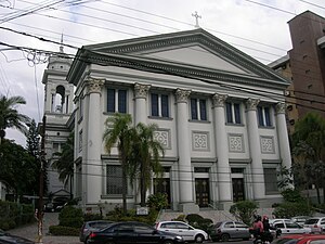
Auxiliadora is a neighbourhood (bairro) in the city of Porto Alegre, the state capital of Rio Grande do Sul, in Brazil. It was created by Law 2022 from December 7, 1959. The neighbourhood was named after the Paróquia Nossa Senhora Auxiliadora, whose building, inspired in the Église de la Madeleine in Paris, was constructed in 1961.
Cristo Redentor, Rio Grande do Sul
Neighborhood in Porto Alegre, Brazil
Distance: Approx. 1133 meters
Latitude and longitude: -30.01166667,-51.15722222
Cristo Redentor (literally Christ the Redeemer in English) is a neighbourhood (bairro) in the city of Porto Alegre, the state capital of Rio Grande do Sul, in Brazil. It was created by Law 2022 from December 7, 1959. The first inhabitants of this neighbourhood were Italian immigrants from Caxias do Sul.
Santa Maria Goretti, Rio Grande do Sul
Distance: Approx. 1065 meters
Latitude and longitude: -30.00583333,-51.17555556
Santa Maria Goretti is a neighbourhood (bairro) in the city of Porto Alegre, the state capital of Rio Grande do Sul, in Brazil. It was created by Law 2688 from December 25, 1963.
Jardim Lindoia
Neighborhood in Porto Alegre, Brazil
Distance: Approx. 1984 meters
Latitude and longitude: -30.00388889,-51.15138889
Jardim Lindoia is a neighbourhood (bairro) in the city of Porto Alegre, the state capital of Rio Grande do Sul, in Brazil. It was created by Law 2022 from December 7, 1959. In 1945, Arno Friedrich started to divide his large property in Jardim Lindoia into many lots.
Jardim Floresta, Rio Grande do Sul
Neighborhood in Porto Alegre
Distance: Approx. 1757 meters
Latitude and longitude: -30,-51.15916667
Jardim Floresta (meaning Forest Garden in English) is a neighbourhood (bairro) in the city of Porto Alegre, the state capital of Rio Grande do Sul, in Brazil. It was created by Law 2022 from December 7, 1959.

Anchieta College (Porto Alegre)
Private primary and secondary school in Porto Alegre, Rio Grande do Sul, Brazil
Distance: Approx. 1785 meters
Latitude and longitude: -30.02833333,-51.17555556
The College Anchieta is a private Catholic primary and secondary school located in Porto Alegre, the capital of Rio Grande do Sul, Brazil. The institution is one of the twenty-two works of the Society of Jesus in Southern Brazil. The school has more than three thousand students and approximately three hundred members on its staff.

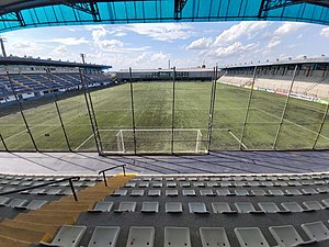
Estádio Passo D'Areia
Multi-use stadium in Porto Alegre, Brazil
Distance: Approx. 883 meters
Latitude and longitude: -30.00664444,-51.17359167
Estádio Francisco Novelletto Neto, better known as Estádio Passo D'Areia is a multi-use stadium located in Porto Alegre, Brazil. It is used mostly for football matches and hosts the home matches of Esporte Clube São José. The stadium has a maximum capacity of 16,000 people and was built in 1940.

Killing of João Alberto Silveira Freitas
2020 killing in Brazil
Distance: Approx. 197 meters
Latitude and longitude: -30.01303,-51.1708
The killing of João Alberto Freitas refers to the beating and killing by asphyxiation of João Alberto Silveira Freitas, at the hands of security guards at a Carrefour store, located in the Passo d'Areia neighborhood, in the northern part of the city of Porto Alegre, in Rio Grande do Sul, on the night of November 19, 2020. The murder started a series of anti-racism protests in several Brazilian cities. Freitas was a forty-year-old black man, who worked as a service provider.
Weather in this IP's area
overcast clouds
17 Celsius
17 Celsius
16 Celsius
17 Celsius
1015 hPa
93 %
1015 hPa
1014 hPa
2000 meters
8.75 m/s
100 degree
100 %
05:18:21
19:02:49


