168.195.240.160 - IP Lookup: Free IP Address Lookup, Postal Code Lookup, IP Location Lookup, IP ASN, Public IP
Country:
Region:
City:
Location:
Time Zone:
Postal Code:
ISP:
ASN:
language:
User-Agent:
Proxy IP:
Blacklist:
IP information under different IP Channel
ip-api
Country
Region
City
ASN
Time Zone
ISP
Blacklist
Proxy
Latitude
Longitude
Postal
Route
db-ip
Country
Region
City
ASN
Time Zone
ISP
Blacklist
Proxy
Latitude
Longitude
Postal
Route
IPinfo
Country
Region
City
ASN
Time Zone
ISP
Blacklist
Proxy
Latitude
Longitude
Postal
Route
IP2Location
168.195.240.160Country
Region
parana
City
maringa
Time Zone
America/Sao_Paulo
ISP
Language
User-Agent
Latitude
Longitude
Postal
ipdata
Country
Region
City
ASN
Time Zone
ISP
Blacklist
Proxy
Latitude
Longitude
Postal
Route
Popular places and events near this IP address

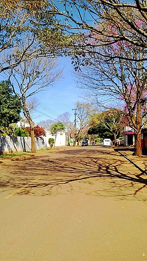
Maringá
Municipality in Paraná, Brazil
Distance: Approx. 3599 meters
Latitude and longitude: -23.4,-51.91666667
Maringá (Portuguese pronunciation: [mɐɾĩˈɡa]) is a municipality in southern Brazil founded on 10 May 1947 as a planned urban area. It is the third largest city in the state of Paraná, with 385,753 inhabitants in the city proper, and 764,906 in the metropolitan area (IBGE 2013). Located in northwestern Paraná, and crossed by the Tropic of Capricorn, it is a regional centre for commerce, services, agro-industries, and universities, including the State University of Maringá.

Maringá Regional Airport
Airport
Distance: Approx. 9886 meters
Latitude and longitude: -23.47638889,-52.01777778
Sílvio Name Júnior Regional Airport (IATA: MGF, ICAO: SBMG), is the airport serving Maringá, Brazil. It is named after Sílvio Name Júnior (1967-2000), a local businessman and politician who died in a plane crash. It is operated by Terminais Aéreos de Maringá – SBMG, a semi-independent Transportation Authority of Maringá, indirectly related to the Municipality of Maringá, and under the supervision of Aeroportos do Paraná (SEIL).
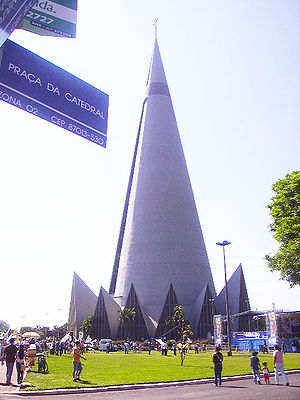
Cathedral of Maringá
Distance: Approx. 124 meters
Latitude and longitude: -23.42638889,-51.93833333
Catedral Basílica Menor Nossa Senhora da Glória (or simply Catedral de Maringá Cathedral of Maringá) is a Roman Catholic cathedral located in downtown Maringá, Paraná, Brazil, reaching 124 metres (407 ft) in height. It was completed in 1972 and is the tallest church building in the Americas and the 18th tallest in the world. Architect José Augusto Bellucci was inspired by the Soviet Sputnik satellites when he designed the cathedral's modernist, conical shape.

State University of Maringá
Public university in Maringá, Brazil
Distance: Approx. 2253 meters
Latitude and longitude: -23.40511111,-51.94008333
The State University of Maringá (Portuguese: Universidade Estadual de Maringá, UEM) is a public university whose main campus is in Maringá, Paraná, Brazil. It was founded in 1970 and recognized in 1976 by the Federal Government of Brazil. Its academic population is estimated in 18,000 people among professors, undergraduates, graduate students and manager technicals.
Roman Catholic Archdiocese of Maringá
Catholic ecclesiastical territory
Distance: Approx. 115 meters
Latitude and longitude: -23.4263,-51.9383
The Roman Catholic Archdiocese of Maringá (Latin: Archidioecesis Maringaënsis) is an archdiocese located in the city of Maringá in Brazil.
Royal Garden
Distance: Approx. 375 meters
Latitude and longitude: -23.42507746,-51.9422616
Royal Garden is the largest residential building in height of Brazil, at 140 metres and 42 floors, according to List of skyscrapers in Brazil. Created in 1988, it's the tallest in the state of Paraná. Designed originally to be the largest in Latin America, this was prevented by the municipal government of the time since its construction during a fire in the 32nd floor was fought with great difficulty due to its height.

Estádio Willie Davids
Distance: Approx. 1241 meters
Latitude and longitude: -23.41416667,-51.93805556
The Estádio Regional Willie Davids is a stadium in Maringá, Brazil. It has a capacity of 14,995 people. It is the home of Grêmio Maringá, Maringá FC and Galo Maringá.

Sarandi, Paraná
City in Paraná, Brazil
Distance: Approx. 6926 meters
Latitude and longitude: -23.44388889,-51.87388889
Sarandi is a Brazilian municipality in the state of Paraná, situated in the mesoregion North Central Paranaense. The population according to the 2020 estimate is 97,803 inhabitants.
Ginásio Chico Neto
Indoor sporting arena in Maringá, Brazil
Distance: Approx. 1499 meters
Latitude and longitude: -23.41183333,-51.93888889
Ginásio Chico Neto, officially named Centro Esportivo Francisco Bueno Neto, is an indoor sporting arena located in Maringá, Brazil. The seating capacity of the arena is 4,538 people and it was opened on 1976. It was named after the Brazilian former football player Chico Netto.
Weather in this IP's area
overcast clouds
22 Celsius
23 Celsius
22 Celsius
22 Celsius
1011 hPa
93 %
1011 hPa
955 hPa
10000 meters
4.29 m/s
10.66 m/s
44 degree
100 %

