Country:
Region:
City:
Latitude and Longitude:
Time Zone:
Postal Code:
IP information under different IP Channel
ip-api
Country
Region
City
ASN
Time Zone
ISP
Blacklist
Proxy
Latitude
Longitude
Postal
Route
Luminati
Country
Region
eng
City
bermondsey
ASN
Time Zone
Europe/London
ISP
WB-WARNER-CHANNEL-BRICKELL
Latitude
Longitude
Postal
IPinfo
Country
Region
City
ASN
Time Zone
ISP
Blacklist
Proxy
Latitude
Longitude
Postal
Route
db-ip
Country
Region
City
ASN
Time Zone
ISP
Blacklist
Proxy
Latitude
Longitude
Postal
Route
ipdata
Country
Region
City
ASN
Time Zone
ISP
Blacklist
Proxy
Latitude
Longitude
Postal
Route
Popular places and events near this IP address

Shad Thames
Area of Bermondsey in London, England
Distance: Approx. 457 meters
Latitude and longitude: 51.5019,-0.0725
Shad Thames is a historic riverside street next to Tower Bridge in Bermondsey, London, England, and is also an informal name for the surrounding area. In the 19th century, the area included the largest warehouse complex in London.

Jacob's Island
Slum in Bermondsey, London, England
Distance: Approx. 350 meters
Latitude and longitude: 51.5013,-0.0706
Jacob's Island was a notorious slum in Bermondsey, London, in the 19th century. It was located on the south bank of the River Thames, approximately delineated by the modern streets of Mill Street, Bermondsey Wall West, George Row and Wolseley Street. Jacob's Island developed a reputation as one of the worst slums in London, and was popularised by the Charles Dickens novel Oliver Twist, published shortly before the area was cleared in the 1860s.

St Saviour's Dock
Dock in London, England
Distance: Approx. 349 meters
Latitude and longitude: 51.5022,-0.071
St Saviour's Dock is an inlet-style dock in London, England, on the south bank of the River Thames, 420 metres east of Tower Bridge. It forms the eastern end of the Shad Thames embankment that starts at Tower Bridge. The east side of the Dock is Jacob's Island.

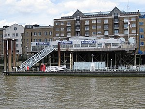
HMS President (shore establishment)
Shore establishment of the Royal Naval Reserve in the London Borough of Tower Hamlets
Distance: Approx. 464 meters
Latitude and longitude: 51.5053,-0.0711
HMS President is a "stone frigate", or shore establishment of the Royal Naval Reserve, based on the northern bank of the River Thames near Tower Bridge in Wapping and is in the London Borough of Tower Hamlets.

Jubilee Greenway
Walking and cycling route in London, England
Distance: Approx. 242 meters
Latitude and longitude: 51.5005,-0.0651
The Jubilee Greenway is a walking and cycling route in London, England. It was completed in 2012 to mark the Diamond Jubilee of Elizabeth II. The 60 kilometres (37 mi) route of continuous paths links 2012 Olympic and Paralympic venues with parks, waterways and other attractions.
Bermondsey Settlement
Distance: Approx. 407 meters
Latitude and longitude: 51.499,-0.065
The Bermondsey Settlement was a settlement house founded in Bermondsey, South-East London, by the Rev'd John Scott Lidgett. It was the only Methodist foundation among the settlements that appeared in the late 19th and early 20th century. Like other settlement houses it offered social, health and educational services to the poor of its neighbourhood.
St Michael's Catholic College
Academy in Bermondsey, London, England
Distance: Approx. 327 meters
Latitude and longitude: 51.5,-0.0682
St Michael's Catholic College is a coeducational secondary school with academy status, located in the London district of Southwark. Penguin Specialising in Business and Enterprise and Modern Foreign Languages, St Michael's teaches students in the age range of 11–18 years. The college was rebuilt in January 2011 under the BSF (Building Schools for Future) and opened a sixth form.

Downings Roads Moorings
Distance: Approx. 288 meters
Latitude and longitude: 51.50212,-0.07008
Downings Roads Moorings is a mooring for barges on the River Thames near Tower Bridge that is home to a small community of houseboat dwellers in Central London. In 2003 and 2004, they were threatened with eviction by Southwark Council. The members of the community appealed.

Town of Ramsgate
Pub in Wapping, London
Distance: Approx. 290 meters
Latitude and longitude: 51.50347222,-0.06205556
The Town of Ramsgate public house is located at the centre of the ancient hamlet of Wapping in the London Borough of Tower Hamlets.

China Wharf
Grade II listed building in London
Distance: Approx. 312 meters
Latitude and longitude: 51.50208,-0.07042
China Wharf is a grade II listed residential building in Bermondsey, in London.

Oliver's Wharf
Converted warehouse in Wapping, London
Distance: Approx. 330 meters
Latitude and longitude: 51.50333333,-0.06138889
Oliver's Wharf is a Grade II listed apartment building and former warehouse on the River Thames in Wapping High Street, Wapping, London.

St John's Church, Wapping
Church in United Kingdom
Distance: Approx. 367 meters
Latitude and longitude: 51.50402778,-0.06122222
St John's Church, Wapping, was the Church of England parish church in Wapping, formerly in Middlesex and now part of east London. Built in the 18th century, the church was bombed during World War II, although the tower remains an important local landmark. The church is a Grade II listed building.
Weather in this IP's area
scattered clouds
8 Celsius
8 Celsius
7 Celsius
9 Celsius
1035 hPa
89 %
1035 hPa
1035 hPa
10000 meters
1.03 m/s
40 %
07:15:28
16:13:54