Country:
 Great Britain
Region:
City:
Latitude and Longitude:
Time Zone:
Postal Code:
IP information under different IP Channel
ip-api
Country
Region
City
ASN
Time Zone
ISP
Blacklist
Proxy
Latitude
Longitude
Postal
Route
IPinfo
Country
Region
City
ASN
Time Zone
ISP
Blacklist
Proxy
Latitude
Longitude
Postal
Route
MaxMind
Country
Region
City
ASN
Time Zone
ISP
Blacklist
Proxy
Latitude
Longitude
Postal
Route
Luminati
Country
GBRegion
eng
City
greenwich
ASN
Time Zone
Europe/London
ISP
WB-WARNER-CHANNEL-BRICKELL
Latitude
Longitude
Postal
db-ip
Country
Region
City
ASN
Time Zone
ISP
Blacklist
Proxy
Latitude
Longitude
Postal
Route
ipdata
Country
Region
City
ASN
Time Zone
ISP
Blacklist
Proxy
Latitude
Longitude
Postal
Route
Popular places and events near this IP address

Watford
Town and borough in Hertfordshire, England
Distance: Approx. 539 meters
Latitude and longitude: 51.655,-0.39569444
Watford ( ) is a town and borough in Hertfordshire, England, 15 mi (24 km) northwest of Central London, on the banks of the River Colne. Initially a small market town, the Grand Junction Canal encouraged the construction of paper-making mills, print works, and breweries. While industry has declined in Watford, its location near London and transport links have attracted several companies to site their headquarters in the town.
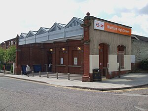
Watford High Street railway station
London Overground station
Distance: Approx. 396 meters
Latitude and longitude: 51.652597,-0.391812
Watford High Street is a railway station in Watford, Hertfordshire, United Kingdom. It is served by the Watford DC line on the London Overground network. It is the only station on the line's sole deviation from the West Coast Main Line.
Watford rail crash
1996 rail crash in England
Distance: Approx. 314 meters
Latitude and longitude: 51.658,-0.3884
In the early evening of 8 August 1996, a Class 321 passenger train operated by Network SouthEast travelling from London Euston on the West Coast Main Line Down Slow line at around 110 km/h (68 mph) passed a signal at danger. Having applied the brakes it eventually stopped 203 m (222 yd) past the signal and was traversing the junction between the Down Slow line and the Up Fast line. An empty Class 321 coaching stock train approaching at roughly 80 km/h (50 mph) collided with the stationary passenger train approximately 700 m south of Watford Junction whilst progressing across the connections from the Up Slow line to the Up Fast line.

Atria Watford
Shopping mall in Hertfordshire, England
Distance: Approx. 433 meters
Latitude and longitude: 51.65527778,-0.39416667
Atria Watford is a shopping centre in the middle of Watford, Hertfordshire, England. It opened in June 1992 as the Harlequin Shopping Centre. The centre was rebranded as intu Watford in 2013 following the renaming of its parent Capital Shopping Centres Group as Intu Properties.

St John's Church, Watford
Church in Hertfordshire, England
Distance: Approx. 561 meters
Latitude and longitude: 51.6586,-0.3939
The Church of St John the Apostle and Evangelist is a Church of England parish church located in Sutton Road, close to the centre of the busy market town of Watford in Hertfordshire. It is within the Diocese of St Albans and has throughout its history been one of the leading Anglo-Catholic churches in the southeast of England. Today it is part of the Richborough Episcopal Area, and lies in the pastoral and sacramental care of the Provincial Episcopal Visitor.
Watford Grammar School for Girls
Partially selective academy in Watford, Hertfordshire, England
Distance: Approx. 706 meters
Latitude and longitude: 51.6515,-0.3962
Watford Grammar School for Girls (commonly abbreviated WGGS) is an academy for girls in Watford in Hertfordshire, UK. Despite its name, it is only a partially selective school, with 25% of entrants admitted on academic ability and 10% on musical aptitude. Its GCSE results were the highest achieved by non-grammar state schools in England in 2007.

Watford Borough Council
Local authority for Watford, England
Distance: Approx. 698 meters
Latitude and longitude: 51.655,-0.398
Watford Borough Council is the local authority for the Watford non-metropolitan district in the south-west of Hertfordshire, England. The council is based in the Town Hall on Hempstead Road. The council comprises 36 councillors plus a directly-elected mayor.

Watford Palace Theatre
Theatre and cinema in Watford, Hertfordshire, England
Distance: Approx. 680 meters
Latitude and longitude: 51.6572,-0.3972
Watford Palace Theatre, opened in 1908, is an Edwardian Grade II listed building in Watford, Hertfordshire. The 600-seat theatre on Clarendon Road was refurbished in 2004. It houses its own rehearsal room, wardrobe, cafe and bar.

Watford Central tube station
Unbuilt London Underground station
Distance: Approx. 704 meters
Latitude and longitude: 51.656444,-0.39789
Watford Central, a planned London Underground station in the centre of Watford, Hertfordshire, was to be the terminus of a proposed extension of the Metropolitan line from the present-day Watford tube station to the High Street opposite Clarendon Road. The proposed station booking hall has long gone, however, the facade was retained and a new building constructed behind it. It is now The Moon Under Water public house.
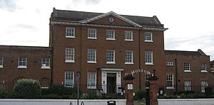
Watford Museum
Local museum in Hertfordshire, United Kingdom
Distance: Approx. 418 meters
Latitude and longitude: 51.652043,-0.391166
Watford Museum is a local museum in Watford, Hertfordshire, in the United Kingdom. It is owned by Watford Borough Council and is located on the Lower High Street in Watford. The museum opened in 1982 and is housed in a Grade II-listed Georgian town house which was previously the premises of Benskins Brewery.

St Mary's Church, Watford
Church in Hertfordshire, England
Distance: Approx. 559 meters
Latitude and longitude: 51.654563,-0.395923
St Mary's Watford is a Church of England church in Watford, Hertfordshire, in England. It is an active church situated in the town centre on Watford High Street, approximately 25 kilometres (16 mi) outside London. St Mary's is the parish church of Watford and is part of the Anglican Diocese of St Albans.

Holy Rood Church, Watford
Church in Watford, England
Distance: Approx. 740 meters
Latitude and longitude: 51.6548,-0.3986
Holy Rood Church is a Roman Catholic Parish church in Watford, Hertfordshire. It was built from 1889 to 1890. It is situated on the western corner of Market Street and Exchange Road.
Weather in this IP's area
few clouds
20 Celsius
20 Celsius
18 Celsius
21 Celsius
1020 hPa
62 %
1020 hPa
1013 hPa
10000 meters
5.66 m/s
100 degree
20 %
06:44:53
19:04:58