168.151.120.244 - IP Lookup: Free IP Address Lookup, Postal Code Lookup, IP Location Lookup, IP ASN, Public IP
Country:
Region:
City:
Location:
Time Zone:
Postal Code:
IP information under different IP Channel
ip-api
Country
Region
City
ASN
Time Zone
ISP
Blacklist
Proxy
Latitude
Longitude
Postal
Route
Luminati
Country
Region
az
City
phoenix
ASN
Time Zone
America/Phoenix
ISP
Geekyworks IT Solutions Pvt Ltd
Latitude
Longitude
Postal
IPinfo
Country
Region
City
ASN
Time Zone
ISP
Blacklist
Proxy
Latitude
Longitude
Postal
Route
IP2Location
168.151.120.244Country
Region
arizona
City
phoenix
Time Zone
America/Phoenix
ISP
Language
User-Agent
Latitude
Longitude
Postal
db-ip
Country
Region
City
ASN
Time Zone
ISP
Blacklist
Proxy
Latitude
Longitude
Postal
Route
ipdata
Country
Region
City
ASN
Time Zone
ISP
Blacklist
Proxy
Latitude
Longitude
Postal
Route
Popular places and events near this IP address

Phoenix, Arizona
Capital and most populous city of Arizona, United States
Distance: Approx. 25 meters
Latitude and longitude: 33.44833333,-112.07388889
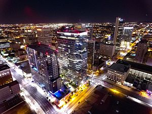
Phoenix ( FEE-niks) is the capital and most populous city of the U.S. state of Arizona, with 1,662,607 residents as of 2024. It is the fifth-most populous city in the United States and the most populous state capital in the country. Phoenix is the most populous city of the Phoenix metropolitan area, also known as the Valley of the Sun, which in turn is part of the Salt River Valley and Arizona Sun Corridor.

1989 United States Grand Prix
Motor car race
Distance: Approx. 55 meters
Latitude and longitude: 33.44791667,-112.07458333
The 1989 United States Grand Prix was a Formula One motor race held in Phoenix, Arizona on June 4, 1989. It was the fifth race of the 1989 Formula One World Championship and the first United States Grand Prix to be held in Phoenix.

1990 United States Grand Prix
Motor car race
Distance: Approx. 55 meters
Latitude and longitude: 33.44791667,-112.07458333
The 1990 United States Grand Prix was the opening motor race of the 1990 Formula One World Championship held on March 11, 1990, in Phoenix, Arizona. It was the 32nd United States Grand Prix since the American Grand Prize was first held in 1908, and the 25th under Formula One regulations since the first United States Grand Prix was held at Sebring, Florida in 1959. It was the second to be held on the streets of Phoenix and ran over 72 laps of the 4 km-circuit.

1991 United States Grand Prix
Motor car race
Distance: Approx. 60 meters
Latitude and longitude: 33.44805556,-112.07472222
The 1991 United States Grand Prix (formally the XXVIII Iceberg United States Grand Prix) was a Formula One motor race held on March 10, 1991 in Phoenix, Arizona. It was the first race of the 1991 Formula One World Championship. The 81-lap race was won from pole position by Ayrton Senna, driving a McLaren-Honda, with Alain Prost second in a Ferrari and Nelson Piquet third in a Benetton-Ford.

Phoenix street circuit
Motorsport track in the United States
Distance: Approx. 55 meters
Latitude and longitude: 33.44791667,-112.07458333
The Formula One United States Grand Prix was held on the Phoenix street circuit in Phoenix, Arizona, between 1989 and 1991. It was held in downtown by the Phoenix Civic Plaza and the America West Arena, prior to the introduction of the state's baseball stadium, Bank One Ballpark. The United States Grand Prix lasted in Phoenix for three years, but was dropped without explanation by Formula One management.

Luhrs Building
Historic building in Arizona
Distance: Approx. 145 meters
Latitude and longitude: 33.4469,-112.0741
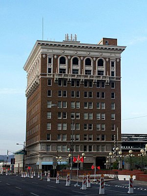
The Moxy Phoenix Downtown is a hotel located in the Luhrs Building, a historic ten-story office building located at 11 West Jefferson in Downtown Phoenix, Arizona. It was listed on the Phoenix Historic Property Register in 1990, and on the National Register of Historic Places in 2024. It was built by local businessman George H. N. Luhrs, an original Phoenix City Council member from 1881–85, at a cost of $553,000 USD, and opened on May 17, 1924.

Arizona Summit Law School
Defunct law school in Phoenix, Arizona
Distance: Approx. 93 meters
Latitude and longitude: 33.448563,-112.073199
The Arizona Summit Law School was a for-profit law school in Phoenix, Arizona, that operated from 2005 to 2018. The law school was known until 2013 as the Phoenix School of Law, and was a part of the InfiLaw System of independent, for-profit law schools, which includes Florida Coastal School of Law and Charlotte School of Law, owned by Sterling Partners. Although the school was accredited by the American Bar Association (ABA) in 2010, it was controversial for its poor bar exam pass rates and unemployability of its students.

Patriots Square Park
Park in Phoenix, Arizona
Distance: Approx. 57 meters
Latitude and longitude: 33.44777778,-112.07444444
Patriots Square Park was an urban park located in downtown Phoenix, Arizona. The space has been redeveloped as part of the larger CityScape office and retail project; large portions of the park were demolished as of the spring of 2009. Before the CityScape project broke ground in the fall of 2007, Patriots Square Park was a 2.5 acre (1 hectare) mixed-use park containing open space, an outdoor performing arts stage, and food concessions.

Jefferson/1st Avenue and Washington/Central Avenue stations
Light rail station in Phoenix, Arizona
Distance: Approx. 45 meters
Latitude and longitude: 33.44826389,-112.07458333
Jefferson/1st Avenue station and Washington/Central Avenue station, also collectively known as Downtown Phoenix and City Hall, is a pair of light rail stations on the Valley Metro Rail in Phoenix, Arizona, United States. It is the sixteenth stop westbound and the thirteenth stop eastbound on the initial 20-mile (32 km) starter line. This station is split between two platforms, the northbound platform on Central Avenue at Washington Street and the southbound on 1st Avenue at Jefferson Street, approximately 800 feet (240 m) apart.

Renaissance Square
High-rise complex in Phoenix, Arizona
Distance: Approx. 67 meters
Latitude and longitude: 33.4487,-112.0745
Renaissance Square is a high-rise complex located in downtown Phoenix, Arizona. The complex includes two towers: One Renaissance Square at 347 ft (106 m) with 26 floors, and Two Renaissance Square at 372 ft (113 m) with 28 floors. Although a part of the same complex, Tower 1 was completed in 1986 while Tower 2 was completed in 1990.

CityScape (Phoenix)
High-rise development in Phoenix, Arizona
Distance: Approx. 114 meters
Latitude and longitude: 33.44791667,-112.07291667
CityScape Phoenix is a high-rise mixed-use development in Downtown Phoenix consisting of residential, retail, office, and hotel components. The development covers three city blocks in the heart of Downtown Phoenix and is located between First Avenue and First Street to the west and east, and between Washington and Jefferson streets to the north and south. A portion of the development was built on the land formerly occupied by Patriots Square Park through a redevelopment agreement with the City of Phoenix.

One North Central
High-rise in Phoenix, Arizona
Distance: Approx. 95 meters
Latitude and longitude: 33.4486,-112.0732
One North Central, formerly the Phelps Dodge Tower, is a high-rise office building located along Central Avenue in the Downtown area of Phoenix, Arizona, United States. Its name is a reference to its street address at 1 N. Central Avenue. The tower rises 20 floors and 290 feet (88 m) in height.
Weather in this IP's area
scattered clouds
17 Celsius
16 Celsius
16 Celsius
19 Celsius
1007 hPa
18 %
1007 hPa
969 hPa
10000 meters
5.66 m/s
70 degree
40 %