168.0.231.241 - IP Lookup: Free IP Address Lookup, Postal Code Lookup, IP Location Lookup, IP ASN, Public IP
Country:
Region:
City:
Location:
Time Zone:
Postal Code:
IP information under different IP Channel
ip-api
Country
Region
City
ASN
Time Zone
ISP
Blacklist
Proxy
Latitude
Longitude
Postal
Route
Luminati
Country
Region
am
City
manaus
ASN
Time Zone
America/Manaus
ISP
Nova Solucoes em Tecnologia
Latitude
Longitude
Postal
IPinfo
Country
Region
City
ASN
Time Zone
ISP
Blacklist
Proxy
Latitude
Longitude
Postal
Route
IP2Location
168.0.231.241Country
Region
amazonas
City
manacapuru
Time Zone
America/Manaus
ISP
Language
User-Agent
Latitude
Longitude
Postal
db-ip
Country
Region
City
ASN
Time Zone
ISP
Blacklist
Proxy
Latitude
Longitude
Postal
Route
ipdata
Country
Region
City
ASN
Time Zone
ISP
Blacklist
Proxy
Latitude
Longitude
Postal
Route
Popular places and events near this IP address

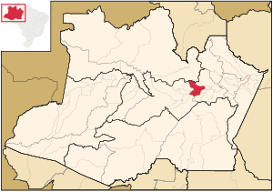
Manacapuru
Municipality in North, Brazil
Distance: Approx. 6 meters
Latitude and longitude: -3.29972222,-60.62055556
Manacapuru (Munychapur) is a municipality located in the Brazilian state of Amazonas.
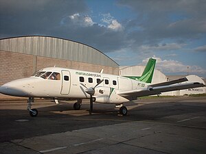
2009 Manaus Aerotáxi Embraer Bandeirante crash
Aviation accident in Brazil
Distance: Approx. 7275 meters
Latitude and longitude: -3.25916667,-60.67194444
The crash of an Embraer EMB-110P1 Bandeirante owned and operated by Manaus Aerotáxi occurred in the state of Amazonas in Brazil on February 7, 2009. At 13:50 local time, a Manaus Aerotáxi Embraer EMB-110P1 Bandeirante twin turboprop, registration PT-SEA, operating as an air taxi flight from Coari (SWKO) to Manaus (SBEG), crashed into the Manacapuru River about 80 kilometers (50 mi) southwest of its destination, killing the two crew and 22 of the 26 passengers on board. The four surviving passengers, who were seated in the rear, managed to escape the sinking plane and swim safely to shore.
Manacapuru River
River in Brazil
Distance: Approx. 9643 meters
Latitude and longitude: -3.25,-60.69166667
Manacapuru River is a river of Amazonas state in north-western Brazil. It flows into the Amazon River (Solimões section) at the city of Manacapuru, about 80 km (50 mi) upstream (west) from Manaus. Parts of the river are very broad, appearing as elongated lakes, with the uppermost known as Lago Grande de Manacapuru ("Large Manacapuru Lake") and the lowermost, near where it merges into the Amazon, as Lago Manacapuru ("Lake Manacapuru").

Rede Amazônica Manacapuru
Television station in Amazonas, Brazil
Distance: Approx. 720 meters
Latitude and longitude: -3.30016667,-60.61413889
Rede Amazônica Manacapuru is a Brazilian television station based in Manacapuru, a city in the state of Amazonas. It operates on analog channel 12 and digital channel 16 (virtual 12.1) and is affiliated to TV Globo. It belongs to Grupo Rede Amazônica.
Weather in this IP's area
broken clouds
25 Celsius
26 Celsius
25 Celsius
25 Celsius
1009 hPa
90 %
1009 hPa
1006 hPa
10000 meters
2.1 m/s
3.58 m/s
94 degree
75 %
