167.94.252.222 - IP Lookup: Free IP Address Lookup, Postal Code Lookup, IP Location Lookup, IP ASN, Public IP
Country:
Region:
City:
Location:
Time Zone:
Postal Code:
ISP:
ASN:
language:
User-Agent:
Proxy IP:
Blacklist:
IP information under different IP Channel
ip-api
Country
Region
City
ASN
Time Zone
ISP
Blacklist
Proxy
Latitude
Longitude
Postal
Route
db-ip
Country
Region
City
ASN
Time Zone
ISP
Blacklist
Proxy
Latitude
Longitude
Postal
Route
IPinfo
Country
Region
City
ASN
Time Zone
ISP
Blacklist
Proxy
Latitude
Longitude
Postal
Route
IP2Location
167.94.252.222Country
Region
utah
City
salem
Time Zone
America/Denver
ISP
Language
User-Agent
Latitude
Longitude
Postal
ipdata
Country
Region
City
ASN
Time Zone
ISP
Blacklist
Proxy
Latitude
Longitude
Postal
Route
Popular places and events near this IP address

Elk Ridge, Utah
City in Utah, United States
Distance: Approx. 3110 meters
Latitude and longitude: 40.00555556,-111.67361111
Elk Ridge is a city in Utah County, Utah, United States. It originally incorporated as a town named Salem Hills. It changed its name in 1978 to Elk Ridge, named for the herds of elk that wintered in the area.

Salem, Utah
City in Utah, United States
Distance: Approx. 2603 meters
Latitude and longitude: 40.05333333,-111.67166667
Salem is a city in Utah County, Utah. It is part of the Provo–Orem metropolitan area. The population was 9,298 at the time of the 2020 U.S. census.

Woodland Hills, Utah
City in Utah, United States
Distance: Approx. 2730 meters
Latitude and longitude: 40.0075,-111.65444444
Woodland Hills is a city in Utah County, Utah, United States. It is part of the Provo–Orem Metropolitan Statistical Area. The population was 1,521 at the 2020 census.
Mountain View Hospital (Payson, Utah)
Hospital in Utah, United States
Distance: Approx. 4760 meters
Latitude and longitude: 40.04388889,-111.71388889
Mountain View Hospital is a JCAHO accredited, 124-bed hospital in Payson, Utah, which has provided medical care to the south Utah County community from its current location for more than 30 years. The hospital was started in 1914 by Dr. A.L. Curtis above the Wilson Drug Store in Payson.

Sri Sri Radha Krishna Temple (Spanish Fork)
Radha Krishna temple in Utah, United States
Distance: Approx. 4912 meters
Latitude and longitude: 40.075703,-111.662122
The Sri Sri Radha Krishna Temple in Utah County, United States is a Hindu temple dedicated to Radha Krishna. It was built to meet the needs of the Hindu community in Utah County. The temple hosts many seasonal festivals, events and weekly services for prayer and meditation.

Peteetneet Museum and Cultural Arts Center
United States historic place
Distance: Approx. 5520 meters
Latitude and longitude: 40.04333333,-111.72333333
The Peteetneet Museum and Cultural Arts Center is a multi-purpose civic building located in Payson, Utah, United States.
Christopher F. Dixon Jr. House
Historic house in Utah, United States
Distance: Approx. 6239 meters
Latitude and longitude: 40.04611111,-111.73111111
The Christopher F. Dixon Jr. House is a historic house located in Payson, Utah, United States. It was listed on the National Register of Historic Places on November 7, 1977.
Ira W. Gardner House
Historic house in Utah, United States
Distance: Approx. 2764 meters
Latitude and longitude: 40.05472222,-111.67222222
The Ira W. Gardner House is a historic house in Salem, Utah, United States was built in 1895. It was listed on the National Register of Historic Places (NRHP) in 1977. According to its NRHP nomination "the Gardner Home is considered the town's landmark residence." The NRHP lists the address as 10 North Main Street, but the actual address of the property is 15 East Center Street.

Payson Presbyterian Church
Historic church in Utah, United States
Distance: Approx. 6088 meters
Latitude and longitude: 40.03527778,-111.73166667
The Payson Presbyterian Church at 160 South Main Street in Payson, Utah, United States was built in 1882. It has also been known as Payson Bible Church. It was listed on the National Register of Historic Places (NRHP) in 1986; the listing included two contributing buildings.

Peteetneet Creek
Stream in Utah County, Utah
Distance: Approx. 5824 meters
Latitude and longitude: 40.03472222,-111.72861111
Peteetneet Creek is a stream in Payson Canyon, south of Payson, Utah, United States.

Dream Mine
Mine in Utah County, Utah, United States
Distance: Approx. 3347 meters
Latitude and longitude: 40.04833333,-111.62777778
The Dream Mine, or Relief Mine, is an unproductive underground mine in Salem, Utah, built by John Hyrum Koyle in the 1890s and incorporated in 1909. Koyle prophesied the mine would provide financial support for members of the Church of Jesus Christ of Latter-day Saints (LDS Church) just before the Second Coming of Jesus Christ. Koyle's prophecies were controversial among leaders of the LDS Church, who excommunicated him in 1948.

Salem Lake (Utah)
Reservoir in Salem, Utah, United States
Distance: Approx. 2492 meters
Latitude and longitude: 40.051,-111.675
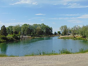
Salem Lake, locally known as Salem Pond, is an 11-acre (4.5 ha) reservoir located in Salem, Utah, United States.
Weather in this IP's area
light snow
-2 Celsius
-6 Celsius
-2 Celsius
-2 Celsius
1016 hPa
58 %
1016 hPa
819 hPa
10000 meters
4.02 m/s
5.36 m/s
203 degree
100 %


