167.94.153.49 - IP Lookup: Free IP Address Lookup, Postal Code Lookup, IP Location Lookup, IP ASN, Public IP
Country:
Region:
City:
Location:
Time Zone:
Postal Code:
IP information under different IP Channel
ip-api
Country
Region
City
ASN
Time Zone
ISP
Blacklist
Proxy
Latitude
Longitude
Postal
Route
Luminati
Country
ASN
Time Zone
America/Chicago
ISP
BEC
Latitude
Longitude
Postal
IPinfo
Country
Region
City
ASN
Time Zone
ISP
Blacklist
Proxy
Latitude
Longitude
Postal
Route
IP2Location
167.94.153.49Country
Region
texas
City
bastrop
Time Zone
America/Chicago
ISP
Language
User-Agent
Latitude
Longitude
Postal
db-ip
Country
Region
City
ASN
Time Zone
ISP
Blacklist
Proxy
Latitude
Longitude
Postal
Route
ipdata
Country
Region
City
ASN
Time Zone
ISP
Blacklist
Proxy
Latitude
Longitude
Postal
Route
Popular places and events near this IP address

Bastrop County, Texas
County in Texas, United States
Distance: Approx. 3836 meters
Latitude and longitude: 30.1,-97.31
Bastrop County is located in the U.S. state of Texas. It is in Central Texas and its county seat is Bastrop. As of the 2020 census, the population was 97,216.

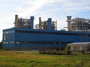
Sim Gideon Power Plant
Power Plant
Distance: Approx. 3338 meters
Latitude and longitude: 30.14555556,-97.27027778
The Sim Gideon Power Plant is a 639 megawatt (MW), natural gas fired power plant located near Bastrop, Texas in Bastrop County, Texas. It is owned and operated by the Lower Colorado River Authority. The Sim Gideon Power Plant consists of three generating units that operate via simple cycle combustion turbine utilizing natural gas.
Lost Pines Power Project 1
Distance: Approx. 3520 meters
Latitude and longitude: 30.14722222,-97.27055556
The Lost Pines Power Project 1 is a natural gas fired power plant located near Bastrop, Texas in Bastrop County, Texas. It is owned by GenTex Power Corporation, a wholly owned affiliate of the Lower Colorado River Authority. The plant, along with Sim Gideon Power Plant, is part of the Lost Pines Power Park.

Bastrop Independent School District
School district in Texas
Distance: Approx. 3938 meters
Latitude and longitude: 30.113061,-97.3153738
Bastrop Independent School District is a public school district in Bastrop, Texas, United States. The district serves the communities of Bastrop, Camp Swift, Cedar Creek, Circle D-KC Estates, Paige, Red Rock, Rockne, Wyldwood, and other rural areas of Bastrop County.

Bastrop State Park
State park and historic site in Texas, United States
Distance: Approx. 561 meters
Latitude and longitude: 30.11083333,-97.27361111
Bastrop State Park is a state park in Bastrop County, Texas, United States. The park was established in 1933 and consists of stands of loblolly pines mixed with post oak and junipers.

T. A. Hasler House
Historic house in Texas, United States
Distance: Approx. 4121 meters
Latitude and longitude: 30.1125,-97.31722222
The T. A. Hasler House is a Classical Revival-style house located in Bastrop, Texas. The two-story house was renovated from a farm house-style dwelling by Marie Hasler, after the death of her husband T. A. Hasler. The structure was listed in the National Register of Historic Places on December 22, 1978.

Kerr Community Center
United States historic place
Distance: Approx. 4182 meters
Latitude and longitude: 30.10861111,-97.31722222
The Kerr Community Center, originally called Kerr Hall, is a community center located in Bastrop, Texas, United States. The hall was a gathering spot for the African-American community of Bastrop during the time of racial segregation in the United States. The structure was listed in the National Register of Historic Places on December 22, 1978.

Lost Pines Forest
Forest
Distance: Approx. 4100 meters
Latitude and longitude: 30.11194444,-97.31694444
The Lost Pines Forest is a 13-mile (21 km) belt of loblolly pines (Pinus taeda) in the U.S. state of Texas, near the town of Bastrop. The stand of pines is unique in Texas because it is a disjunct population of trees that is more than 100 miles (160 km) separated from, and yet closely genetically related to, the vast expanse of pine trees of the Piney Woods region that covers parts of Texas, Arkansas, Louisiana, and Oklahoma.
Bastrop High School (Texas)
High school in Bastrop, Bastrop County, Texas, United States
Distance: Approx. 3564 meters
Latitude and longitude: 30.1183,-97.3115
Bastrop High School is a public high school in Bastrop, Texas (USA) the UIL classifies as a 5A school. It is part of the Bastrop Independent School District located in central Bastrop County. During 2022–2023, Bastrop High School had an enrollment of 1,621 students and a student to teacher ratio of 15.10.

Bastrop County Courthouse and Jail Complex
United States historic place
Distance: Approx. 3958 meters
Latitude and longitude: 30.11277778,-97.31555556
The Bastrop County Courthouse is a historic courthouse built in 1883 at 803 Pine St, Bastrop, Texas. The Renaissance Revival style building was designed by J. N. Preston & Son. It was added to the National Register of Historic Places on November 20, 1975.
Genesis High School
Public high school in Bastrop, Texas, United States
Distance: Approx. 3769 meters
Latitude and longitude: 30.117199,-97.313708
Genesis High School is a secondary alternative school located in Bastrop, Texas, in the Bastrop Independent School District. The school serves all of BISD, including the cities of Bastrop, Cedar Creek, Red Rock, Rockne, Paige and other rural areas of Bastrop County. For the 2021-2022 school year, the school was given a "C" by the Texas Education Agency.
Emile School
School
Distance: Approx. 3664 meters
Latitude and longitude: 30.1068,-97.3112
Emile School or Emile High School was a segregated high school for African-American students in Bastrop, Texas. A part of the Bastrop Independent School District, it opened in 1893. The school, named after the book Emile, or On Education, housed grades 1-12.
Weather in this IP's area
overcast clouds
9 Celsius
8 Celsius
9 Celsius
11 Celsius
1026 hPa
68 %
1026 hPa
1008 hPa
10000 meters
2.94 m/s
5.12 m/s
38 degree
86 %