Country:
 Canada
Region:
City:
Latitude and Longitude:
Time Zone:
Postal Code:
IP information under different IP Channel
ip-api
Country
Region
City
ASN
Time Zone
ISP
Blacklist
Proxy
Latitude
Longitude
Postal
Route
IPinfo
Country
Region
City
ASN
Time Zone
ISP
Blacklist
Proxy
Latitude
Longitude
Postal
Route
MaxMind
Country
Region
City
ASN
Time Zone
ISP
Blacklist
Proxy
Latitude
Longitude
Postal
Route
Luminati
Country
CARegion
on
City
toronto
ASN
Time Zone
America/Toronto
ISP
TEKSAVVY
Latitude
Longitude
Postal
db-ip
Country
Region
City
ASN
Time Zone
ISP
Blacklist
Proxy
Latitude
Longitude
Postal
Route
ipdata
Country
Region
City
ASN
Time Zone
ISP
Blacklist
Proxy
Latitude
Longitude
Postal
Route
Popular places and events near this IP address
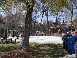
Rosedale, Toronto
Neighbourhood in Toronto, Ontario, Canada
Distance: Approx. 642 meters
Latitude and longitude: 43.679,-79.378
Rosedale is a neighbourhood in central Toronto, Ontario, Canada. It was formerly the estate of William Botsford Jarvis, and so named by his wife, granddaughter of William Dummer Powell, for the wild roses that grew there in abundance. It is located north of Downtown Toronto and is one of its oldest suburbs.

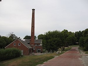
Don Valley Brick Works
Former quarry and industrial site in Toronto, Canada
Distance: Approx. 649 meters
Latitude and longitude: 43.684667,-79.36528
The Don Valley Brick Works (often referred to as the Evergreen Brick Works) is a former quarry and industrial site located in the Don River Valley in Toronto, Ontario, Canada. The Don Valley Brick Works operated for nearly 100 years and provided bricks used to construct many well-known Toronto landmarks, such as Casa Loma, Osgoode Hall, Massey Hall, and the Ontario Legislature. Since the closure of the original factory, the quarry has been converted into a city park which includes a series of naturalized ponds, while the buildings have been restored and opened as an environmentally focused community and cultural centre by Evergreen, a national charity dedicated to restoring nature in urban environments.

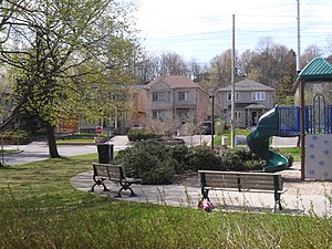
Moore Park, Toronto
Neighbourhood in Toronto, Ontario, Canada
Distance: Approx. 879 meters
Latitude and longitude: 43.691,-79.377
Moore Park is a neighbourhood in Toronto, Ontario, Canada. It is one of Toronto's most affluent neighbourhoods. Toronto Life ranked the Rosedale-Moore Park neighbourhood as the best neighbourhood to live in Toronto.

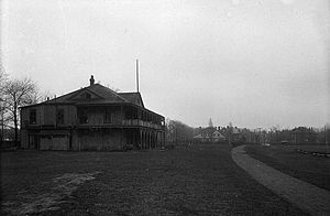
Government House (Ontario)
Official residences in Toronto, Canada
Distance: Approx. 375 meters
Latitude and longitude: 43.686054,-79.370009
Government House was the official residence of the lieutenant governor of Upper Canada and Ontario, Canada. Four buildings were used for this purpose, none of which exist today, making Ontario one of four provinces not to have an official vice-regal residence.

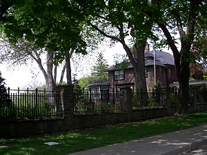
Branksome Hall
School in Toronto, Ontario, Canada
Distance: Approx. 1093 meters
Latitude and longitude: 43.6751,-79.38
Branksome Hall is an independent day and boarding school for girls in Toronto, Ontario, Canada. It is Toronto's only all-years International Baccalaureate (IB) World School for girls. Branksome Hall is located on a 13-acre campus in the Toronto neighbourhood of Rosedale and educates more than 900 students from Junior Kindergarten to Grade 12.
Rosedale Field
Distance: Approx. 452 meters
Latitude and longitude: 43.6825,-79.37861111
Rosedale Field was a grandstand stadium located in Rosedale Park at 20 Scholfield Avenue, Toronto, Ontario, Canada. Originally called the Toronto Lacrosse Grounds, it was linked to St. Andrew's College, located in the area west of MacLennan Avenue from Summerhill Avenue to Douglas Drive (now a residential area).
Todmorden Mills
Former paper mill and settlement on the Don River in Toronto
Distance: Approx. 1084 meters
Latitude and longitude: 43.68625,-79.36024
Todmorden Mills was a small settlement located in the Don River valley in Toronto, Ontario. It started out as a lumber mill in the 1790s. Originally known as "Don Mills", it grew into a small industrial complex and village before becoming part of East York in the 20th century.
Governor's Bridge, Toronto
Neighbourhood in Toronto, Ontario, Canada
Distance: Approx. 1007 meters
Latitude and longitude: 43.691,-79.366
Governor's Bridge is a bridge and small neighbourhood in Toronto, Ontario, Canada, located to the east of Rosedale and Moore Park neighbourhoods. Unlike them, it was part of the former city of East York. The neighbourhood is named for the Governor's Bridge that crosses the Moore Park Ravine from Douglas Crescent to Astley Avenue and connects the area to Rosedale.
University of Toronto President's Estate
Official residence of the President of the University of Toronto
Distance: Approx. 324 meters
Latitude and longitude: 43.68111111,-79.37527778
The University of Toronto President's Estate is a 3.5-acre (1.4 ha) property with a 32-room residence for the president of the University of Toronto. It is located at 93 Highland Avenue in the Rosedale neighbourhood of Toronto, Ontario, Canada. The property overlooks the Park Drive Reservation Ravine formed by Yellow Creek and goes from Highland Avenue halfway down to the floor of the ravine.

Integral House
Distance: Approx. 356 meters
Latitude and longitude: 43.6846,-79.369
Integral House is a private residence located at 194 Roxborough Drive in the Rosedale neighbourhood of Toronto, Ontario, Canada. The project was commissioned by mathematician James Stewart as a residence incorporating a performance space, and was designed by Brigitte Shim and Howard Sutcliffe of the Toronto architectural firm Shim-Sutcliffe Architects. The name of the house is derived from the mathematical integral symbol, commonly used in calculus; Stewart's wealth derived from his authorship of widely used calculus textbooks.
Mud Creek (Toronto)
Stream in Toronto, Canada
Distance: Approx. 1060 meters
Latitude and longitude: 43.6927952,-79.3766196
Mud Creek is a mostly buried south-easterly tributary of the Don River in Toronto, Ontario, Canada. It has also been known at different times as Mount Pleasant Brook and Spring Valley Creek. At its full former reach, the source of Mud Creek began near Downsview Airport, from which the creek flowed approximately 11.5km southeast to its mouth at the Don River.

Rosedale Presbyterian Church
Presbyterian Church in Toronto, Ontario, Canada
Distance: Approx. 1020 meters
Latitude and longitude: 43.675912,-79.380104
Rosedale Presbyterian Church is a congregation of the Presbyterian Church Canada located at 129 Mount Pleasant Road in the Rosedale neighbourhood of Toronto, Ontario, Canada.
Weather in this IP's area
clear sky
25 Celsius
25 Celsius
24 Celsius
26 Celsius
1023 hPa
55 %
1023 hPa
1010 hPa
10000 meters
2.47 m/s
4.12 m/s
113 degree
06:58:31
19:26:01