Country:
 Canada
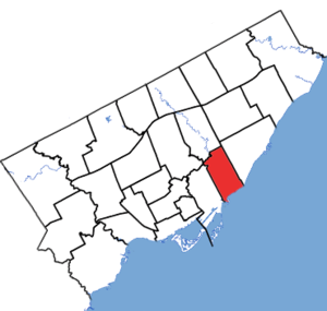
Region:
City:
Latitude and Longitude:
Time Zone:
Postal Code:
IP information under different IP Channel
ip-api
Country
Region
City
ASN
Time Zone
ISP
Blacklist
Proxy
Latitude
Longitude
Postal
Route
IPinfo
Country
Region
City
ASN
Time Zone
ISP
Blacklist
Proxy
Latitude
Longitude
Postal
Route
MaxMind
Country
Region
City
ASN
Time Zone
ISP
Blacklist
Proxy
Latitude
Longitude
Postal
Route
Luminati
Country
CARegion
on
City
toronto
ASN
Time Zone
America/Toronto
ISP
TEKSAVVY
Latitude
Longitude
Postal
db-ip
Country
Region
City
ASN
Time Zone
ISP
Blacklist
Proxy
Latitude
Longitude
Postal
Route
ipdata
Country
Region
City
ASN
Time Zone
ISP
Blacklist
Proxy
Latitude
Longitude
Postal
Route
Popular places and events near this IP address

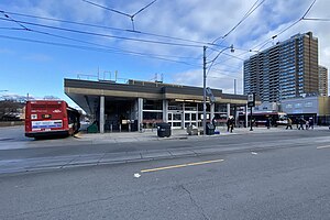
Woodbine station
Toronto subway station
Distance: Approx. 556 meters
Latitude and longitude: 43.68638889,-79.31277778
Woodbine is a subway station on Line 2 Bloor–Danforth in Toronto, Ontario, Canada. The station is at the southeast corner of Woodbine Avenue and Strathmore Boulevard, just north of Danforth Avenue.
Main Street station (Toronto)
Toronto subway station
Distance: Approx. 687 meters
Latitude and longitude: 43.68902778,-79.30166667
Main Street is a station on Line 2 Bloor–Danforth in Toronto, Ontario, Canada and is located on the east side of Main Street a short distance north of Danforth Avenue. Connections to GO Transit's commuter train service on the Lakeshore East line can be made at Danforth GO Station, approximately 300 metres to the south on the east side of Main Street. Wi-Fi service is available at this station.
Beaches—East York (federal electoral district)
Federal electoral district in Ontario, Canada
Distance: Approx. 830 meters
Latitude and longitude: 43.685,-79.31611111
Beaches—East York (formerly Beaches—Woodbine) is a federal electoral district in Toronto, Ontario, Canada, that has been represented in the House of Commons of Canada since 1988. This riding is situated east of Toronto's downtown. According to the 2016 census, Beaches—East York has a population of 109,468 and is not known for its ethnic diversity compared to other ridings in Toronto.

Danforth GO Station
Railway station in Toronto, Ontario, Canada
Distance: Approx. 977 meters
Latitude and longitude: 43.68666667,-79.29916667
Danforth GO Station is a railway station on GO Transit's Lakeshore East line in Toronto, Ontario, Canada. The station is situated in the east end of Old Toronto, south west of the intersection of Main Street and Danforth Avenue. The station is a short walk from Main Street station on Line 2 Bloor–Danforth of the Toronto subway.

Old East York
Neighbourhood in Toronto, Ontario, Canada
Distance: Approx. 555 meters
Latitude and longitude: 43.69330556,-79.31583333
Old East York is a district of the city of Toronto, Ontario, Canada. It consists of the southern, urban, portion of the former borough of East York. Old East York is continuous and functionally integrated with the old City of Toronto, bounded by the old municipal boundary between East York and Old Toronto on the south (which runs variably a few to several blocks north of Danforth Avenue), by the Don River Valley on the west and northwest, by Taylor-Massey Creek on the north, and Victoria Park Avenue in the east.

Beaches—East York (provincial electoral district)
Provincial electoral district in Ontario, Canada
Distance: Approx. 994 meters
Latitude and longitude: 43.68444444,-79.31833333
Beaches—East York is a provincial riding in Toronto, Ontario, Canada. It elects one member to the Legislative Assembly of Ontario. It was created in 1996 from parts of Beaches—Woodbine (95%), Don Mills (40%), and York East (20%).

Upper Beaches
Neighbourhood in Toronto, Ontario, Canada
Distance: Approx. 1113 meters
Latitude and longitude: 43.682088,-79.303272
The Upper Beaches is a neighbourhood in Toronto, Ontario, Canada. It is directly north of the Beaches area. It stretches from Coxwell Avenue in the west to Victoria Park in the east.

Main Square (Toronto)
Distance: Approx. 833 meters
Latitude and longitude: 43.687682,-79.300459
Main Square is a complex of four apartment buildings in Toronto, Canada. The three-hectare site houses about 2000 people. It is located in the eastern part of the city at the intersection of Main Street and Danforth Avenue.

East Danforth
Neighbourhood in Toronto, Ontario, Canada
Distance: Approx. 707 meters
Latitude and longitude: 43.68805556,-79.30194444
East Danforth, also known as Danforth Village, is an informal neighbourhood in the east end of Toronto, Ontario, Canada. It is located on the eastern part of Danforth Avenue, from the eastern edge of Greektown by Greenwood Avenue to the boundary of Scarborough at Victoria Park Avenue. The area is covered by two business improvement associations, Danforth Village and Danforth Mosaic.

Ted Reeve Community Arena
Multi-purpose arena in Toronto
Distance: Approx. 1118 meters
Latitude and longitude: 43.68444444,-79.29916667
The Ted Reeve Community Arena is a multi-purpose arena that is located on 175 Main Street and Gerrard Street East in Toronto, Ontario, Canada. The building was opened in 1954 and named in commemoration to Canadian athlete Ted Reeve, and underwent repair work in 1997 The arena was also used for interior shots as the home of the fictional "Hamilton Mustangs" in the 1986 movie Youngblood starring Rob Lowe and Patrick Swayze. In 2004, the Arena expanded to include a second skating rink adjacent to the building, a vinyl covered dome colloquially known as The Bubble.
Woodbine Building Supply fire
2001 arson in Toronto, Ontario, Canada
Distance: Approx. 687 meters
Latitude and longitude: 43.6853,-79.3134
On December 24, 2001, arsonists set fire to the Woodbine Building Supply Company building in Toronto, Ontario, Canada, causing an explosion and leading to one of the largest fires in the city's history. The arsonists were conspiring with John Magno, co-owner of the store, who desired to destroy the struggling business to collect a fraudulent insurance claim and clear the site for construction of a condominium development. The fire led to the evacuation of over 50 homes on Christmas morning, and the death of one of the arsonists.

Luttrell Loop
Former Toronto streetcar terminus
Distance: Approx. 1269 meters
Latitude and longitude: 43.68944444,-79.29416667
The Toronto Transit Commission's Luttrell Loop was the eastern terminus of the Bloor streetcar line. The loop was closed in 1968 after completion of an extension of the Bloor–Danforth subway line. In 1913, the Toronto Civic Railways, owned by the City of Toronto, opened its Danforth streetcar line along Danforth Avenue from Broadview Avenue to Luttrell Avenue.
Weather in this IP's area
clear sky
25 Celsius
25 Celsius
24 Celsius
27 Celsius
1023 hPa
58 %
1023 hPa
1009 hPa
10000 meters
3.09 m/s
80 degree
06:58:16
19:25:46