Country:
 Canada
Region:
City:
Latitude and Longitude:
Time Zone:
Postal Code:
IP information under different IP Channel
ip-api
Country
Region
City
ASN
Time Zone
ISP
Blacklist
Proxy
Latitude
Longitude
Postal
Route
IPinfo
Country
Region
City
ASN
Time Zone
ISP
Blacklist
Proxy
Latitude
Longitude
Postal
Route
MaxMind
Country
Region
City
ASN
Time Zone
ISP
Blacklist
Proxy
Latitude
Longitude
Postal
Route
Luminati
Country
CARegion
on
City
toronto
ASN
Time Zone
America/Toronto
ISP
TEKSAVVY
Latitude
Longitude
Postal
db-ip
Country
Region
City
ASN
Time Zone
ISP
Blacklist
Proxy
Latitude
Longitude
Postal
Route
ipdata
Country
Region
City
ASN
Time Zone
ISP
Blacklist
Proxy
Latitude
Longitude
Postal
Route
Popular places and events near this IP address

Fort York
Historic British garrison in Toronto, Canada
Distance: Approx. 496 meters
Latitude and longitude: 43.63888889,-79.40361111
Fort York (French: Fort-York) is an early 19th-century military fortification in the Fort York neighbourhood of Toronto, Ontario, Canada. The fort was used to house members of the British and Canadian militaries, and to defend the entrance of the Toronto Harbour. The fort features stone-lined earthwork walls and eight historical buildings within them, including two blockhouses.

Factory Theatre
Theatre in Toronto, Ontario, Canada
Distance: Approx. 388 meters
Latitude and longitude: 43.645573,-79.402721
Factory Theatre is a theatre in Toronto, Ontario, Canada. It was founded as Factory Theatre Lab in 1970 by Ken Gass and Frank Trotz, and it was run for almost 20 years by Dian English. Factory theatre was the first to announce that it would exclusively produce Canadian plays, but it soon became a widely emulated policy by other theatre companies.

Sir Isaac Brock Bridge
Distance: Approx. 264 meters
Latitude and longitude: 43.640357,-79.40127
The Sir Isaac Brock Bridge is a steel Warren truss bridge in Toronto, Ontario, Canada. It lies along Bathurst Street over the railway tracks between Front Street and Fort York Boulevard. The bridge carries four lanes for motor vehicles with the centre lanes containing the streetcar tracks of the Toronto Transit Commission's 511 Bathurst streetcar route.

CityPlace, Toronto
Neighbourhood in Ontario, Canada
Distance: Approx. 495 meters
Latitude and longitude: 43.640044,-79.395179
CityPlace is a neighbourhood in Downtown Toronto, Ontario, Canada, within the former Railway Lands. When completed, this area will be the largest residential development ever created in Toronto. The area is bordered by Bathurst Street to the west, Lake Shore Boulevard to the south, and Front Street to the north and Blue Jays Way and Rogers Centre to the east.

Fashion District, Toronto
Neighbourhood in Toronto, Ontario, Canada
Distance: Approx. 321 meters
Latitude and longitude: 43.645,-79.398
The Fashion District (formerly known as the Garment District) is a commercial and residential district in Downtown Toronto, Ontario, Canada. It is located between the intersection of Bathurst Street to the west, Spadina Avenue to the east, Queen Street West to the north and Front Street to the south. Google Maps extends the district further east of Spadina Avenue to Peter Street.
St. Andrew's Market and Playground
Park in Toronto, Ontario, Canada
Distance: Approx. 445 meters
Latitude and longitude: 43.64647,-79.39883
St. Andrew's Playground is a small park in downtown Toronto. It is located at the 450 Adelaide Street West, at the northwest corner of Brant St and Adelaide.

Victoria Memorial Square
Park and former cemetery in Toronto
Distance: Approx. 4 meters
Latitude and longitude: 43.642638,-79.4002
Victoria Memorial Square is a park and former cemetery in Toronto, Ontario, Canada. Established in 1793 as the burial place for those affiliated with the nearby Toronto Garrison (Fort York). It was the first cemetery to be used by European settlers in what would become the city of Toronto.

Canoe Landing Park
Park in Toronto, Ontario, Canada
Distance: Approx. 490 meters
Latitude and longitude: 43.639,-79.3967
Canoe Landing Park is an 8 acres (3.2 ha) privately funded urban park in downtown Toronto, Ontario, Canada, adjacent to the Gardiner Expressway in the CityPlace neighbourhood. The name was chosen as part of a city-run contest and the final name was announced on the t.o.night free evening commuter paper. Formerly, it was tentatively known as CityPlace Park.
Tapestry Opera
Canadian opera company in Toronto, Ontario
Distance: Approx. 390 meters
Latitude and longitude: 43.6456,-79.4027
Tapestry Opera is a Canadian opera company located in Toronto, Ontario. According to its website, it is "the only Canadian company solely dedicated to the creation and performance of original Canadian opera". To date, the company has produced 18 full-length world premieres and 160 world premieres of opera shorts.
ALPHA Alternative School
Public school in Toronto, Canada
Distance: Approx. 381 meters
Latitude and longitude: 43.6457,-79.3982
ALPHA Alternative School is an alternative public school in Toronto, Ontario, Canada. Founded in 1972, it is Toronto's oldest elementary alternative school. It was created by parents, and inspired in good part by the Ontario government's Hall-Dennis Report.
Spadina–Front GO Station
Planned commuter train station in Toronto
Distance: Approx. 425 meters
Latitude and longitude: 43.64194444,-79.395
Spadina–Front GO Station (also referred to as Spadina GO Station) is a planned GO Transit train station to be built by Metrolinx in Toronto, Ontario, Canada, as part of the approved GO Transit Regional Express Rail. It will be situated downtown, south of Front Street between Spadina Avenue and Bathurst Street near office and residential towers. The station will be adjacent to the future Rail Deck Park, an urban park proposed by the City of Toronto.
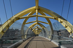
Puente de Luz
Bridge in Toronto, Ontario, Canada
Distance: Approx. 248 meters
Latitude and longitude: 43.641102,-79.397917
Puente de Luz is a bridge in Toronto, Ontario, Canada. The bridge was designed by Chilean artist Francisco Gazitua.
Weather in this IP's area
clear sky
25 Celsius
25 Celsius
23 Celsius
27 Celsius
1023 hPa
58 %
1023 hPa
1014 hPa
10000 meters
3.09 m/s
90 degree
06:58:39
19:26:06