Country:
 Canada
Region:
City:
Latitude and Longitude:
Time Zone:
Postal Code:
IP information under different IP Channel
ip-api
Country
Region
City
ASN
Time Zone
ISP
Blacklist
Proxy
Latitude
Longitude
Postal
Route
IPinfo
Country
Region
City
ASN
Time Zone
ISP
Blacklist
Proxy
Latitude
Longitude
Postal
Route
MaxMind
Country
Region
City
ASN
Time Zone
ISP
Blacklist
Proxy
Latitude
Longitude
Postal
Route
Luminati
Country
CARegion
on
City
toronto
ASN
Time Zone
America/Toronto
ISP
TEKSAVVY
Latitude
Longitude
Postal
db-ip
Country
Region
City
ASN
Time Zone
ISP
Blacklist
Proxy
Latitude
Longitude
Postal
Route
ipdata
Country
Region
City
ASN
Time Zone
ISP
Blacklist
Proxy
Latitude
Longitude
Postal
Route
Popular places and events near this IP address
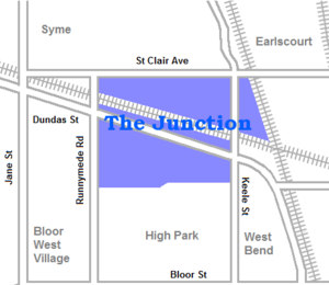
The Junction
Neighbourhood in Toronto, Ontario, Canada
Distance: Approx. 734 meters
Latitude and longitude: 43.66555556,-79.46444444
The Junction is a neighbourhood in Toronto, Ontario, Canada, that is near the West Toronto Diamond, a junction of four railway lines in the area. The neighbourhood was previously an independent city called West Toronto, that was also its own federal electoral district until amalgamating with the city of Toronto in 1909. The main intersection of the area is Dundas Street West and Keele Street.
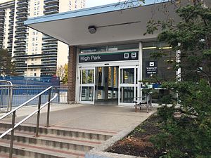
High Park station
Toronto subway station
Distance: Approx. 666 meters
Latitude and longitude: 43.65388889,-79.46666667
High Park is a subway station on Line 2 Bloor–Danforth of the Toronto subway in Toronto, Ontario, Canada. It is located just north of Bloor Street West, spanning the block east of Quebec Avenue to High Park Avenue. It opened in 1968 as part of the westerly extension from Keele to Islington station.

Dundas West station
Toronto subway station
Distance: Approx. 816 meters
Latitude and longitude: 43.65694444,-79.45291667
Dundas West is a subway station on Line 2 Bloor–Danforth of the Toronto subway in Toronto, Ontario, Canada. It is located just north of Bloor Street West at the corner of Dundas Street and Edna Avenue. The station is about 200 metres west of Bloor GO Station on the GO Transit Kitchener line and the Union Pearson Express.

Keele station
Toronto subway station
Distance: Approx. 458 meters
Latitude and longitude: 43.65555556,-79.45972222
Keele is a subway station on Line 2 Bloor–Danforth of the Toronto subway in Toronto, Ontario, Canada. It is located just north of Bloor Street West on the east side of Keele Street. The station opened in 1966, and was the western terminus of the line until 1968.

Portuguese Seventh-day Adventist Church (Toronto)
Distance: Approx. 684 meters
Latitude and longitude: 43.6624908,-79.4696884
The Portuguese Seventh-day Adventist Church is a Seventh-day Adventist church serving the Portuguese community of Toronto, Ontario, Canada. The congregation is currently meeting every Saturday at the High Park Korean United Church building located at 260 High Park Ave.

West Toronto Railpath
Multi-use trail in Toronto, Canada
Distance: Approx. 748 meters
Latitude and longitude: 43.66118,-79.45377
The West Toronto Railpath is a multi-use trail in Toronto, Ontario, Canada, running from The Junction neighbourhood toward downtown Toronto. The Railpath was developed by the City of Toronto for bicycle and pedestrian use. Like Toronto's Beltline and Don Mills trails, it is an urban rail-to-trail project.

High Park Forest School
Distance: Approx. 882 meters
Latitude and longitude: 43.6512,-79.4635
High Park Forest School is a former special school in High Park, Toronto, Ontario, Canada. It was a school founded to provide a boost to children who were tubercular or had other physical detriments. Today, it is an outdoor environmental education facility run by a local non-profit organization called the High Park Nature Centre.
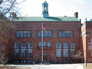
Humberside Collegiate Institute
High school in High Park North, Toronto, Ontario, Canada
Distance: Approx. 657 meters
Latitude and longitude: 43.659943,-79.470677
Humberside Collegiate Institute (also known as Humberside CI, HCI, or Humberside), formerly known as Toronto Junction High School and Toronto Junction Collegiate Institute is a public high school located in Toronto, Ontario, Canada. It serves the Bloor West Village, Baby Point, High Park North and Junction neighbourhoods. Prior to 1998, it was within the Toronto Board of Education (TBE).

Jami Mosque (Toronto)
Mosque in Toronto, Ontario, Canada
Distance: Approx. 927 meters
Latitude and longitude: 43.6532,-79.45448
Jami Mosque (مسجد جامع) is a mosque in Toronto, Ontario, Canada. Located just east of High Park, it is the oldest Canadian Islamic centre in the city and dubbed "the mother of all the mosques in Toronto". Built in 1930 as a Presbyterian church, the building was purchased in 1969 by Toronto's small, predominantly Bosniak and Albanians Muslim community and converted into the city's first Islamic worship centre.
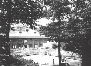
Ravina Gardens
Ice hockey arena
Distance: Approx. 867 meters
Latitude and longitude: 43.659675,-79.47333889
Ravina Gardens was an ice hockey arena located in Toronto, Ontario, Canada. It supported amateur hockey from before World War I until 1961, and professional hockey briefly in the 1920s. The location of the demolished arena is parkland, and is known as Ravina Gardens.

The Crossways (Toronto)
Building complex in Toronto, Ontario
Distance: Approx. 906 meters
Latitude and longitude: 43.65694,-79.45175
The Crossways is a mixed-use residential/commercial complex in the west end of Toronto, Ontario, Canada, located at the intersection of Bloor Street West and Dundas Street West. It stretches across most of a city block.
Keele Yard
Distance: Approx. 664 meters
Latitude and longitude: 43.65636,-79.45527
Keele Yard (originally known as Vincent Yard) is a rail yard on the Toronto Transit Commission's (TTC's) Line 2 Bloor–Danforth of the Toronto subway system. Keele Yard is located between Dundas West and Keele stations.
Weather in this IP's area
clear sky
25 Celsius
25 Celsius
24 Celsius
27 Celsius
1022 hPa
56 %
1022 hPa
1010 hPa
10000 meters
3.09 m/s
80 degree
06:58:53
19:26:21