167.7.30.20 - IP Lookup: Free IP Address Lookup, Postal Code Lookup, IP Location Lookup, IP ASN, Public IP
Country:
Region:
City:
Location:
Time Zone:
Postal Code:
ISP:
ASN:
language:
User-Agent:
Proxy IP:
Blacklist:
IP information under different IP Channel
ip-api
Country
Region
City
ASN
Time Zone
ISP
Blacklist
Proxy
Latitude
Longitude
Postal
Route
db-ip
Country
Region
City
ASN
Time Zone
ISP
Blacklist
Proxy
Latitude
Longitude
Postal
Route
IPinfo
Country
Region
City
ASN
Time Zone
ISP
Blacklist
Proxy
Latitude
Longitude
Postal
Route
IP2Location
167.7.30.20Country
Region
south carolina
City
columbia
Time Zone
America/New_York
ISP
Language
User-Agent
Latitude
Longitude
Postal
ipdata
Country
Region
City
ASN
Time Zone
ISP
Blacklist
Proxy
Latitude
Longitude
Postal
Route
Popular places and events near this IP address

St. Andrews, South Carolina
Census-designated place in South Carolina, United States
Distance: Approx. 271 meters
Latitude and longitude: 34.04361111,-81.09777778
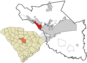
St. Andrews is a census-designated place (CDP) in Richland County, South Carolina, United States. The population was 20,493 at the 2010 census.
Midlands of South Carolina
Distance: Approx. 2637 meters
Latitude and longitude: 34.06,-81.08
The Midlands region of South Carolina is the middle area of the state. The region's main center is Columbia, the state's capital. The Midlands is so named because it is halfway point between the Upstate and the Lowcountry.
Millrace Rapids
Distance: Approx. 3625 meters
Latitude and longitude: 34.012,-81.08
Millrace Rapids is a popular kayaking playspot, located on the Lower Saluda River in Columbia, South Carolina.
Columbia High School (South Carolina)
Public high school in Columbia, South Carolina, United States
Distance: Approx. 1113 meters
Latitude and longitude: 34.05,-81.09166667
Columbia High School a public high school in the St. Andrews area of Columbia, South Carolina, United States. Columbia High School was originally housed in the former Columbia Female Academy (established 1816) at 1323 Washington Street at the corner with Marion Street.
Eau Claire, South Carolina
Community in South Carolina, United States
Distance: Approx. 2707 meters
Latitude and longitude: 34.06111111,-81.08055556
Eau Claire is a community in Columbia, South Carolina.
Camille Griffin Graham Correctional Institution
State prison for women in Columbia, South Carolina
Distance: Approx. 3145 meters
Latitude and longitude: 34.06944444,-81.09833333
Camille Griffin Graham Correctional Institution is a South Carolina Department of Corrections (SCDC) state prison for women in Columbia, South Carolina. The Women's Reception and Evaluation Center, which processes all females entering SCDC, is in the prison. The prison opened in 1973, as "Women's Correctional Institution".

Dutch Square
Shopping mall in Columbia, South Carolina
Distance: Approx. 1040 meters
Latitude and longitude: 34.033,-81.092
Dutch Square is an enclosed shopping mall located in the city of Columbia, South Carolina. Currently, it features more than forty stores and restaurants, as well an AMC movie theater. Its anchor stores are Burlington Coat Factory and Office Depot.
Broad River Correctional Institution
State prison in South Carolina, US
Distance: Approx. 3670 meters
Latitude and longitude: 34.07416667,-81.09777778
The Broad River Correctional Institution (BRCI) is a South Carolina Department of Corrections state prison for men located in Columbia, South Carolina. South Carolina's execution chamber is located in Broad River. The adjacent Kirkland Correctional Institution lies just to its south side.
NashiCon
Anime convention
Distance: Approx. 2211 meters
Latitude and longitude: 34.03194444,-81.11861111
NashiCon was an annual three-day anime convention held traditionally during March/April at the DoubleTree by Hilton Hotel Columbia, South Carolina in Columbia, South Carolina. It was the first anime convention in South Carolina and Nashi stands for Nippon Anime Society of Heavenly Imagery.
Saluda Factory Historic District
Archaeological site in South Carolina, United States
Distance: Approx. 3846 meters
Latitude and longitude: 34.0081,-81.08544
Saluda Factory Historic District is a national historic district located at West Columbia, Lexington County, South Carolina. It encompasses three contributing sites associated with the development of the area along the Saluda River; Saluda Factory, Camp Sorghum and old State Road. The Saluda Factory ruins consist of the granite foundation and sluices from a textile mill that operated on the river between the years 1834 and 1884.

Pine Grove Rosenwald School
United States historic place
Distance: Approx. 3310 meters
Latitude and longitude: 34.06222222,-81.12277778
Pine Grove Rosenwald School, also known as Pine Grove Colored School, is a historic Rosenwald school building located at St. Andrews, Richland County, South Carolina. It was built in 1923, and is a one-story, rectangular gable-front frame building.
Kirkland Correctional Institution
Prison in Columbia, South Carolina
Distance: Approx. 3146 meters
Latitude and longitude: 34.06944444,-81.09861111
Kirkland Correctional Institution is a state prison for men located in Columbia, Richland County, South Carolina, United States, owned and operated by the South Carolina Department of Corrections. Kirkland has a special role in South Carolina's prison system as the point of intake and assessment for all male state prisoners, the site of the state's Maximum Security Unit, and a health care facility. The prison was first opened in 1975, and houses a maximum of 1707 inmates, plus another 50 in the Max unit and 24 in the infirmary.
Weather in this IP's area
clear sky
-5 Celsius
-5 Celsius
-6 Celsius
-4 Celsius
1032 hPa
90 %
1032 hPa
1020 hPa
10000 meters
