Country:
 France
Region:
City:
Latitude and Longitude:
Time Zone:
Postal Code:
IP information under different IP Channel
ip-api
Country
Region
City
ASN
Time Zone
ISP
Blacklist
Proxy
Latitude
Longitude
Postal
Route
IPinfo
Country
Region
City
ASN
Time Zone
ISP
Blacklist
Proxy
Latitude
Longitude
Postal
Route
MaxMind
Country
Region
City
ASN
Time Zone
ISP
Blacklist
Proxy
Latitude
Longitude
Postal
Route
Luminati
Country
 SE
SEASN
Time Zone
Europe/Stockholm
ISP
OVH SAS
Latitude
Longitude
Postal
db-ip
Country
Region
City
ASN
Time Zone
ISP
Blacklist
Proxy
Latitude
Longitude
Postal
Route
ipdata
Country
Region
City
ASN
Time Zone
ISP
Blacklist
Proxy
Latitude
Longitude
Postal
Route
Popular places and events near this IP address

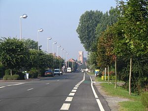
Gravelines
Commune in Hauts-de-France, France
Distance: Approx. 242 meters
Latitude and longitude: 50.9858,2.1283
Gravelines (, grav-LEEN; French pronunciation: [gʁavlin]; Dutch: Grevelingen Dutch pronunciation: [ˈɣreː.və.lɪ.ŋə(n)]) is a commune in the Nord department in Northern France. It lies at the mouth of the river Aa 15 miles (24 km) southwest of Dunkirk. It was formed in the 12th century around the mouth of a canal built to connect Saint-Omer with the sea.

Aa (France)
River in northern France
Distance: Approx. 2556 meters
Latitude and longitude: 51.00583333,2.10444444
The Aa (French pronunciation: [a]; Picard: Abbe) is a river in northern France that is 93 km (58 miles) long. Originating near the village of Bourthes and emptying into the North Sea near Gravelines, the Aa is located near the north-eastern limit of the English Channel. The Aa has been canalized for most of its length and forms much of the border between the regions of Pas-de-Calais and Nord.

Battle of Gravelines (1558)
Battle of the Italian War near Calais, France
Distance: Approx. 196 meters
Latitude and longitude: 50.98722222,2.12833333
The Battle of Gravelines was fought on 13 July 1558 at Gravelines, near Calais, France. It occurred during the twelve-year war between France and Spain (1547–1559). The battle resulted in a victory by the Spanish forces, led by Lamoral, Count of Egmont, over the French, led by Marshal Paul de Thermes.

Gravelines Sportica
Indoor sporting arena in France
Distance: Approx. 1342 meters
Latitude and longitude: 50.999023,2.122743
Gravelines Sportica was an indoor sporting arena located in Gravelines, France. The capacity of the arena is 3,500 people. It is home to the Basket Club Maritime Gravelines Dunkerque Grand Littoral basketball team.
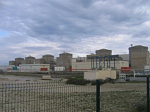
Gravelines Nuclear Power Station
Nuclear power plant in France
Distance: Approx. 3223 meters
Latitude and longitude: 51.01527778,2.13611111
The Gravelines Nuclear Power Station is a nuclear power plant located near the commune of Gravelines in Nord, France, approximately 20 km (12 mi) from Dunkerque and Calais. Its cooling water comes from the North Sea. The plant consists of 6 nuclear reactors of 900 MW each.

Oye-Plage
Commune in Hauts-de-France, France
Distance: Approx. 5723 meters
Latitude and longitude: 50.9786,2.045
Oye-Plage (French pronunciation: [wa plaʒ]; West Flemish: Ooie) is a commune in the Pas-de-Calais department in the Hauts-de-France region of France.

Saint-Folquin
Commune in Hauts-de-France, France
Distance: Approx. 4478 meters
Latitude and longitude: 50.9469,2.1233
Saint-Folquin (French pronunciation: [sɛ̃fɔlkɛ̃]; West Flemish: Sint-Volkwin) is a commune in the Pas-de-Calais department in the Hauts-de-France region of France named for a 9th-century Christian saint named Folquin.

Saint-Omer-Capelle
Commune in Hauts-de-France, France
Distance: Approx. 5535 meters
Latitude and longitude: 50.9397,2.1017
Saint-Omer-Capelle (French pronunciation: [sɛ̃.t‿ɔmɛʁ kapɛl]; West Flemish: Sint-Omaarskapelle) is a commune in the Pas-de-Calais department in the Hauts-de-France region of France.
Loon-Plage
Commune in Hauts-de-France, France
Distance: Approx. 6714 meters
Latitude and longitude: 50.9947,2.2206
Loon-Plage (French pronunciation: [lon plaʒ]; Dutch: Loon) is a commune in the Nord department in northern France.

Saint-Georges-sur-l'Aa
Commune in Hauts-de-France, France
Distance: Approx. 3428 meters
Latitude and longitude: 50.9689,2.165
Saint-Georges-sur-l'Aa (French pronunciation: [sɛ̃ ʒɔʁʒ syʁ la], literally Saint-Georges on the Aa; Dutch: Sint-Joris-aan-de-Aa) is a commune in the Nord department in northern France.

Grand-Fort-Philippe
Commune in Hauts-de-France, France
Distance: Approx. 1136 meters
Latitude and longitude: 50.99,2.11
Grand-Fort-Philippe (French pronunciation: [ɡʁɑ̃ fɔʁ filip]; Dutch: Groot-Fort-Filips) is a commune in the Nord department in northern France.
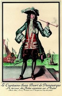
Jean Bart (2002)
Distance: Approx. 555 meters
Latitude and longitude: 50.9864,2.1177
Jean Bart is the name given to the replica of a 1670, 84-gun, ship-of-the-line, that is being constructed by the Association Tourville at Gravelines, Dunkirk, to the plans of the seventeenth century ship builder Colbert. It has European funding through the Heroes2c programme.
Weather in this IP's area
clear sky
16 Celsius
16 Celsius
14 Celsius
16 Celsius
1007 hPa
89 %
1007 hPa
1006 hPa
10000 meters
5.51 m/s
11.57 m/s
179 degree
3 %
07:16:27
20:22:05