167.216.143.7 - IP Lookup: Free IP Address Lookup, Postal Code Lookup, IP Location Lookup, IP ASN, Public IP
Country:
Region:
City:
Location:
Time Zone:
Postal Code:
IP information under different IP Channel
ip-api
Country
Region
City
ASN
Time Zone
ISP
Blacklist
Proxy
Latitude
Longitude
Postal
Route
Luminati
Country
ASN
Time Zone
America/Chicago
ISP
CENTURYLINK-LEGACY-SAVVIS
Latitude
Longitude
Postal
IPinfo
Country
Region
City
ASN
Time Zone
ISP
Blacklist
Proxy
Latitude
Longitude
Postal
Route
IP2Location
167.216.143.7Country
Region
california
City
san jose
Time Zone
America/Los_Angeles
ISP
Language
User-Agent
Latitude
Longitude
Postal
db-ip
Country
Region
City
ASN
Time Zone
ISP
Blacklist
Proxy
Latitude
Longitude
Postal
Route
ipdata
Country
Region
City
ASN
Time Zone
ISP
Blacklist
Proxy
Latitude
Longitude
Postal
Route
Popular places and events near this IP address

SAP Center
Arena in California, United States
Distance: Approx. 435 meters
Latitude and longitude: 37.33277778,-121.90111111
SAP Center at San Jose (originally known as San Jose Arena and HP Pavilion at San Jose) is an indoor arena located in San Jose, California. Its primary tenant is the San Jose Sharks of the National Hockey League, for which the arena has earned the nickname "The Shark Tank".

Peralta Adobe
Historic house in California, United States
Distance: Approx. 295 meters
Latitude and longitude: 37.33640278,-121.89475278
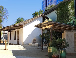
The Peralta Adobe (Spanish: Adobe Peralta), also known as the Luis María Peralta Adobe or the Gonzales-Peralta Adobe, is the oldest building in San Jose, California. The adobe was built in 1797 by José Manuel Gonzeles, one of the founders of San Jose, and is named after Luis María Peralta, its most famous resident.

Tower 55
Commercial offices, Data center in San Jose, California
Distance: Approx. 594 meters
Latitude and longitude: 37.3342,-121.8916
Tower 55 (formerly the Market Post Tower; also known as the Gold Building or simply 55 South Market) is a 15-story building at the corner of South Market Street and Post Street in downtown San Jose, California. Built in 1985 as the Market Post Tower, it was designed to provide a mix of office and retail space. When first built, the building was controversial due to its gold-colored glass exterior, which produced high light and heat reflection.
San Fernando station (VTA)
VTA light rail station in San Jose, California
Distance: Approx. 615 meters
Latitude and longitude: 37.33027778,-121.89833333
San Fernando station (officially San Fernando/SAP Center station) is a light rail station operated by Santa Clara Valley Transportation Authority. The station has two side platforms and two trackways. San Fernando station is served by the Green Line of the VTA light rail system.
Saint James station (VTA)
VTA light rail station in San Jose, California
Distance: Approx. 590 meters
Latitude and longitude: 37.3381,-121.892
Saint James station is a light rail station operated by Santa Clara Valley Transportation Authority. The station is located in Downtown San Jose, California on 1st and 2nd Streets between Saint James and Saint John Streets. The northbound platform is on 1st Street (the address is 150 N. First Street); the southbound platform is on 2nd Street (the address is 101 N. Second Street).

Hotel De Anza
United States historic place
Distance: Approx. 311 meters
Latitude and longitude: 37.33431944,-121.89501667
The Hotel De Anza is a historic hotel in San Jose, California. At ten stories, it once was the tallest hotel in the San Jose central business district, prior to the construction of Hilton, Fairmont, and Marriott hotels. Significant for its architectural style, it is one of San Jose's few Zig Zag Moderne (Art Deco) buildings.
Timeline of San Jose, California
Distance: Approx. 327 meters
Latitude and longitude: 37.333333,-121.9
The following is a timeline of the history of San Jose, California, United States.

San Jose electric light tower
Distance: Approx. 526 meters
Latitude and longitude: 37.335488,-121.892074
The San Jose electric light tower, also known as Owen's Electric Tower after its creator and chief booster, was constructed in 1881 at an intersection in downtown San Jose, California, as a "high light" or moonlight tower to light the city using arc lights. A pioneer use of electricity for municipal lighting, it was later strung with incandescent bulbs and was destroyed in a storm in December 1915. A half-size replica stands at History Park at Kelley Park.
Washburn Preparatory School
Preparatory school in California, United States
Distance: Approx. 367 meters
Latitude and longitude: 37.33861111,-121.89583333
Washburn Preparatory School or Washburn College Preparatory School (1894–1911) was a private preparatory school that was located at 165 Devine Street at the corner of San Pedro Street in San Jose, California.

Market Street Depot
Distance: Approx. 605 meters
Latitude and longitude: 37.341,-121.896
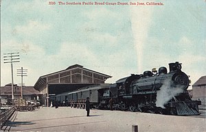
Market Street Depot was the primary intercity railway station in San Jose, California between 1883 and 1935. It was located at Market and Bassett Streets at the end of the former San Francisco and San Jose Railroad, a route which was later integrated into the Southern Pacific Railroad Coast Line.
San Jose Chamber of Commerce
Distance: Approx. 568 meters
Latitude and longitude: 37.335,-121.89166667
The San Jose Chamber of Commerce, is a chamber of commerce representing business interests in the Greater San Jose, California Area. It is the largest chamber of commerce in the Silicon Valley region. Founded in 1886, the chamber has played a role in the development of the local economy and politics.

Moir Building
Historic building in California, United States
Distance: Approx. 601 meters
Latitude and longitude: 37.33972222,-121.89333333
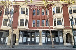
The Moir Building, was formerly the Straford Hotel, and then in the 1930s named the St. James Hotel. It is a historic building located in downtown San Jose, California, next to the St.
Weather in this IP's area
few clouds
7 Celsius
6 Celsius
6 Celsius
9 Celsius
1026 hPa
88 %
1026 hPa
1023 hPa
10000 meters
2.06 m/s
190 degree
20 %

