167.183.212.254 - IP Lookup: Free IP Address Lookup, Postal Code Lookup, IP Location Lookup, IP ASN, Public IP
Country:
Region:
City:
Location:
Time Zone:
Postal Code:
IP information under different IP Channel
ip-api
Country
Region
City
ASN
Time Zone
ISP
Blacklist
Proxy
Latitude
Longitude
Postal
Route
Luminati
Country
ASN
Time Zone
America/Chicago
ISP
NSH167
Latitude
Longitude
Postal
IPinfo
Country
Region
City
ASN
Time Zone
ISP
Blacklist
Proxy
Latitude
Longitude
Postal
Route
IP2Location
167.183.212.254Country
Region
georgia
City
atlanta
Time Zone
America/New_York
ISP
Language
User-Agent
Latitude
Longitude
Postal
db-ip
Country
Region
City
ASN
Time Zone
ISP
Blacklist
Proxy
Latitude
Longitude
Postal
Route
ipdata
Country
Region
City
ASN
Time Zone
ISP
Blacklist
Proxy
Latitude
Longitude
Postal
Route
Popular places and events near this IP address

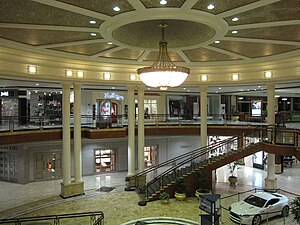
Phipps Plaza
Shopping mall
Distance: Approx. 3274 meters
Latitude and longitude: 33.85312,-84.36217
Phipps Plaza is a shopping mall in the Buckhead area of Atlanta, Georgia. It is located at the intersection of Peachtree Road (SR 141) and Lenox Road (SR 141 Connector), adjacent to the Phipps Tower office building. The mall is currently owned and managed by Simon Property Group, and is considered a sister mall to the adjacent, Simon-owned Lenox Square.
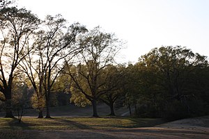
Nancy Creek (Atlanta)
Stream in Georgia, United States
Distance: Approx. 1457 meters
Latitude and longitude: 33.86916667,-84.37888889
Nancy Creek is a 16.3-mile-long (26.2 km) stream in northern Atlanta, Georgia, United States. It begins in far northern DeKalb County, just north of Chamblee, and flows southwestward into Fulton County, through the far southeast corner of Sandy Springs, then through the Buckhead area of Atlanta. It empties into Peachtree Creek, which then flows into the Chattahoochee River, south of Vinings and Paces.

The Galloway School
Private school in Atlanta, Georgia, United States
Distance: Approx. 2058 meters
Latitude and longitude: 33.87485,-84.39361
The Galloway School is a private school in Atlanta, Georgia, United States. It was founded by Elliott Galloway in 1969 and preschool through grade 12.

Chastain Park
City park in Atlanta, Georgia, United States of America
Distance: Approx. 2223 meters
Latitude and longitude: 33.876772,-84.396157
Chastain Memorial Park (originally known as the North Fulton Park, commonly known as Chastain Park) is the second largest city park in Atlanta, Georgia. It is a 268-acre (1.08 km2) park near the northern edge of the city. Included in the park are jogging paths, playgrounds, NYO ball fields, tennis courts, a golf course, swimming pool, horse park and amphitheater.

Park Avenue Condominiums
Distance: Approx. 3054 meters
Latitude and longitude: 33.8553,-84.3618
Park Avenue Condominiums is a 486 ft (148m) tall skyscraper in Atlanta, Georgia. Construction was completed in 2000. The building has 44 floors and 3 basement levels for parking.
North Buckhead
Human settlement in Atlanta, Georgia, United States of America
Distance: Approx. 1810 meters
Latitude and longitude: 33.865252,-84.368863
North Buckhead is a neighborhood in the Buckhead district, at the northern edge of the city of Atlanta, Georgia, and is one of Atlanta's most affluent neighborhoods. With a population of 8,270 (2010 census), it is also Atlanta's fourth most populous neighborhood, after Downtown, Midtown, and the Old Fourth Ward.
Phipps Tower
Office tower in Buckhead, Atlanta, Georgia, U.S.
Distance: Approx. 3262 meters
Latitude and longitude: 33.8528,-84.364
Phipps Tower is a 20-story office tower in Buckhead, Atlanta. It is adjacent to the Phipps Plaza shopping center. John Hancock Life Insurance Company owns, manages and leases the building.
Greenfield Hebrew Academy
Jewish day school in Georgia, US
Distance: Approx. 1739 meters
Latitude and longitude: 33.895952,-84.36651
Katherine and Jacob Greenfield Hebrew Academy (GHA), founded in 1953, was the first Jewish day school in Metro Atlanta, Georgia, United States. It was located in Sandy Springs. GHA was also the first Jewish day school in the country to be accredited by the Southern Association of Colleges and Schools (SACS), and has been honored twice as a National School of Excellence by the Council for American Private Education.

Atlanta Jewish Academy
Distance: Approx. 1738 meters
Latitude and longitude: 33.895946,-84.366505
Atlanta Jewish Academy was created by the merger of Greenfield Hebrew Academy and Yeshiva Atlanta on July 1, 2014. The school is the first Infant through 12th grade Jewish day school in Greater Atlanta. It previously had two campuses, the lower school located in Sandy Springs and the upper school located in Doraville.
Cadence Bank Amphitheatre
Music venue in Atlanta, Georgia
Distance: Approx. 2290 meters
Latitude and longitude: 33.876969,-84.396948
The Cadence Bank Amphitheatre (originally known as North Fulton Park Amphitheatre and formerly Chastain Park Amphitheater) is an outdoor amphitheatre within historic Chastain Park in Atlanta, Georgia. The venue, designed by Nelson Brackin, opened in 1944 and is decreed "Atlanta’s Oldest Outdoor Music Venue". The venue attracts more than 200,000 spectators per season.
Brookhaven Historic District
Historic district in Georgia, United States
Distance: Approx. 2832 meters
Latitude and longitude: 33.86361111,-84.35055556
The Brookhaven Historic District in Atlanta, Georgia is a 300 acres (120 ha) historic district which was listed on the National Register of Historic Places in 1986. The listing included 202 contributing buildings and two contributing structures. It is located east of Peachtree-Dunwoody Road and north and east of Peachtree Road.
The Chastain
Restaurant in Atlanta, Georgia, U.S.
Distance: Approx. 2382 meters
Latitude and longitude: 33.87277778,-84.39638889
The Chastain is a restaurant in Atlanta, in the U.S. state of Georgia. The restaurant serves American, New American, and Southern cuisine. It received a green star from the Michelin Guide in 2023.
Weather in this IP's area
light rain
1 Celsius
-4 Celsius
-0 Celsius
1 Celsius
1016 hPa
81 %
1016 hPa
978 hPa
10000 meters
5.14 m/s
290 degree
75 %

