167.160.8.132 - IP Lookup: Free IP Address Lookup, Postal Code Lookup, IP Location Lookup, IP ASN, Public IP
Country:
 Spain
SpainRegion:
City:
Location:
Time Zone:
Postal Code:
ISP:
ASN:
language:
User-Agent:
Proxy IP:
Blacklist:
IP information under different IP Channel
ip-api
Country
Region
City
ASN
Time Zone
ISP
Blacklist
Proxy
Latitude
Longitude
Postal
Route
db-ip
Country
Region
City
ASN
Time Zone
ISP
Blacklist
Proxy
Latitude
Longitude
Postal
Route
IPinfo
Country
Region
City
ASN
Time Zone
ISP
Blacklist
Proxy
Latitude
Longitude
Postal
Route
IP2Location
167.160.8.132Country
esRegion
valenciana, comunidad
City
rafal
Time Zone
Europe/Madrid
ISP
Language
User-Agent
Latitude
Longitude
Postal
ipdata
Country
Region
City
ASN
Time Zone
ISP
Blacklist
Proxy
Latitude
Longitude
Postal
Route
Popular places and events near this IP address

Almoradí
Municipality in Valencian Community, Spain
Distance: Approx. 5248 meters
Latitude and longitude: 38.10972222,-0.78944444
Almoradí (Spanish pronunciation: [almoɾaˈði]) is a town and municipality located in the comarca of Vega Baja del Segura, in the province of Alicante, Spain, close to the mouth of the river Segura. Almoradí has an area of 42.72 km² and, according to the 2011 census, a total population of 19,280 inhabitants; the latest official estimate (as at the start of 2020) is 21,208. The economy of Almoradí is mainly based on agriculture (vegetables, fruits and lemons).

Benejúzar
Municipality in Valencian Community, Spain
Distance: Approx. 3121 meters
Latitude and longitude: 38.07777778,-0.83861111
Benejúzar (Spanish: [beneˈxuθaɾ]; Valencian: Benejússer) is a town and municipality located in the comarca of Vega Baja del Segura, in the province of Alicante, Spain. Benejúzar has an area of 9.3 km² and, according to the 2005 census, a total population of 5,249 inhabitants. The economy of Benejúzar is mainly based on agriculture (lime farming).

Algorfa
Municipality in Valencian Community, Spain
Distance: Approx. 4406 meters
Latitude and longitude: 38.08583333,-0.80472222
Algorfa (Spanish pronunciation: [alˈɣoɾfa]) is a village in the Costa Blanca area of Spain, near the coast and surrounded by Mediterranean pine forest and citrus groves. Algorfa lies on the banks of the Segura river and is approximately ten minutes' drive to the nearest blue flag beaches of the Mediterranean and a 35 minutes' drive from the Alicante Airport and the Murcia–San Javier Airport. It is a ten minute drive inland from the coastal resort of Guardamar del Segura.
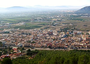
Cox, Spain
Municipality in Valencian Community, Spain
Distance: Approx. 4983 meters
Latitude and longitude: 38.13944444,-0.88472222
Cox (Spanish: [koks]) is a municipality in the comarca of Vega Baja del Segura in the Valencian Community, Spain. This town is located at the feet of the Sierra de Callosa mountain range.
La Campaneta
Place in Alicante, Spain
Distance: Approx. 3828 meters
Latitude and longitude: 38.08333333,-0.88333333
La Campaneta is a parish belonging to the municipality of Orihuela, Alicante, Spain, with a population of around 1225. It has a large shoe industry, as well as various agricultural companies.

San Martin, Callosa de Segura
Distance: Approx. 3328 meters
Latitude and longitude: 38.12277778,-0.87916667
San Martín, Obispo de Tours is a Renaissance-style, Roman Catholic archpresbyteral church (iglesia arciprestal) located in the town of in Callosa de Segura, Alicante, Spain. It has been declared a historic monument.

Sierra de Callosa
Mountain range in Spain
Distance: Approx. 4651 meters
Latitude and longitude: 38.12388889,-0.89611111
Sierra de Callosa (Valencian: Serra de Callosa) is a 4.6 km (3 mi) long mountain range in the Vega Baja del Segura (Valencian: Baix Segura) comarca, Valencian Community, Spain. Its highest point is Águila (572 m). This range is named after the town of Callosa de Segura located at the feet of the mountains.
Redován
Municipality in Valencian Community, Spain
Distance: Approx. 5060 meters
Latitude and longitude: 38.11388889,-0.90555556
Redován is a municipality in the comarca of Vega Baja del Segura in the Valencian Community, Spain. This town is located at the feet of the Sierra de Callosa mountain range. Redovan is one of the Vega Baja (low fertile valley) villages of the southern Costa Blanca, Spain.

Jacarilla
Distance: Approx. 4497 meters
Latitude and longitude: 38.06666667,-0.86666667
Jacarilla (Valencian: Xacarella) is a municipality and village in the province of Alicante and autonomous community of Valencia, Spain. The municipality covers an area of 12.2 square kilometres (4.7 sq mi) and as of 2011 had a population of 2,102 people.

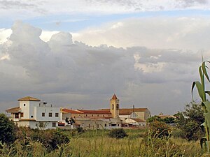
Rafal, Spain
Distance: Approx. 1465 meters
Latitude and longitude: 38.1,-0.83333333
Rafal is a municipality in the Valencian Community (Spain) situated in the south of the province of Alicante, in the comarca of Vega Baja del Segura. The municipality covers an area of 1.6 square kilometres (0.62 sq mi) and as of 2011 had a population of 4,162 people.

Correntías Bajas
Place in Alicante, Spain
Distance: Approx. 4200 meters
Latitude and longitude: 38.067,-0.853
Correntías Bajas is a village in Alicante, Spain.

El Mudamiento
Place in Alicante, Spain
Distance: Approx. 2035 meters
Latitude and longitude: 38.11958,-0.835693
El Mudamiento is a village in Alicante, Spain. It is part of the municipality of Orihuela.
Weather in this IP's area
broken clouds
14 Celsius
14 Celsius
14 Celsius
15 Celsius
1019 hPa
72 %
1019 hPa
1004 hPa
10000 meters
2.68 m/s
4.47 m/s
209 degree
67 %