Country:
 Canada
Region:
City:
Latitude and Longitude:
Time Zone:
Postal Code:
IP information under different IP Channel
ip-api
Country
Region
City
ASN
Time Zone
ISP
Blacklist
Proxy
Latitude
Longitude
Postal
Route
IPinfo
Country
Region
City
ASN
Time Zone
ISP
Blacklist
Proxy
Latitude
Longitude
Postal
Route
MaxMind
Country
Region
City
ASN
Time Zone
ISP
Blacklist
Proxy
Latitude
Longitude
Postal
Route
Luminati
Country
CARegion
on
City
fergus
ASN
Time Zone
America/Toronto
ISP
WIGHT-AS
Latitude
Longitude
Postal
db-ip
Country
Region
City
ASN
Time Zone
ISP
Blacklist
Proxy
Latitude
Longitude
Postal
Route
ipdata
Country
Region
City
ASN
Time Zone
ISP
Blacklist
Proxy
Latitude
Longitude
Postal
Route
Popular places and events near this IP address

Wellington County, Ontario
County in Ontario, Canada
Distance: Approx. 6560 meters
Latitude and longitude: 43.75,-80.4
Wellington County is a county located in Southwestern Ontario, Canada and is part of the Greater Golden Horseshoe. The county, made up of two towns and five townships, is predominantly rural in nature. However many of the residents in the southern part of the county commute to urban areas such as Guelph, Kitchener, Waterloo, Brampton, Mississauga, Toronto and Hamilton for employment.

Elora, Ontario
Unincorporated community in Ontario, Canada
Distance: Approx. 5450 meters
Latitude and longitude: 43.685,-80.42722222
Elora is a community in the township of Centre Wellington, Wellington County, Ontario, Canada. It is well known for its 19th-century limestone architecture and the geographically significant Elora Gorge. Elora is no longer an independent entity.
Centre Wellington
Township in Ontario, Canada
Distance: Approx. 449 meters
Latitude and longitude: 43.7,-80.36666667
Centre Wellington is a township in south-central Ontario, Canada, located in Wellington County. The primary communities are Elora and Fergus. The area is agricultural but also includes industries such as manufacturing.
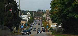
Fergus, Ontario
Unincorporated community in Ontario, Canada
Distance: Approx. 1545 meters
Latitude and longitude: 43.70305556,-80.37972222
Fergus is the largest community in Centre Wellington, a township within Wellington County in Ontario, Canada. It lies on the Grand River about 18 km NNW of Guelph. The population of this community at the time of the 2016 Census was 20,767, but the community is growing as new homes are being built for sale.
Centre Wellington District High School
High school in Fergus, Ontario, Canada
Distance: Approx. 605 meters
Latitude and longitude: 43.70175,-80.3566
Centre Wellington District High School, or CWDHS, is a fully composite high school located in Fergus, Ontario. The school was originally called Fergus High School and was constructed in 1928. Later, two additions were built, but eventually, the number of students exceeded the capacity of the building.
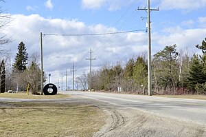
Spier, Ontario
Unincorporated rural community in Ontario, Canada
Distance: Approx. 4533 meters
Latitude and longitude: 43.73861111,-80.36333333
Spier (also Spires) is an unincorporated rural community in Centre Wellington Township, Wellington County, Ontario, Canada. The settlement was part of West Garafraxa Township until 1999.
Fergus (Royland Field) Aerodrome
Airport in Fergus, Ontario
Distance: Approx. 5251 meters
Latitude and longitude: 43.74194444,-80.38527778
Fergus (Royland Field) Aerodrome, formerly TC LID: CPR9, is a defunct airport that was located 2 nautical miles (3.7 km; 2.3 mi) north of Fergus, Ontario, Canada.
Fergus (Vodarek Field) Aerodrome
Airport in Fergus, Ontario
Distance: Approx. 6488 meters
Latitude and longitude: 43.72305556,-80.28916667
Fergus (Vodarek Field) Aerodrome (TC LID: CVF2) is located 4 nautical miles (7.4 km; 4.6 mi) east northeast of Fergus, Ontario, Canada.
CICW-FM
Radio station in Fergus, Ontario
Distance: Approx. 1537 meters
Latitude and longitude: 43.70473,-80.3785
CICW-FM is a radio station broadcasting local programming with a Bright AC Music format on the frequency of 101.1 MHz in Elora and Fergus located in Centre Wellington, Ontario, Canada. The station is branded as The Grand @ 101.

Grand River Raceway
Distance: Approx. 6175 meters
Latitude and longitude: 43.67307222,-80.4305
Grand River Raceway is an entertainment, racing, and gaming destination located in Elora, Ontario, Canada. It opened in 2002 with 200 slot machines operated by Ontario Lottery and Gaming. That subsequently increased to 230+ machines.
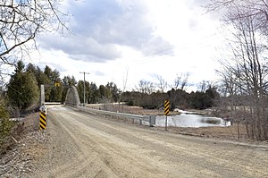
Irvine Creek (Ontario)
River in Ontario, Canada
Distance: Approx. 6177 meters
Latitude and longitude: 43.68166667,-80.43527778
Irvine Creek is a creek in the municipality of Centre Wellington, Wellington County in southwestern Ontario, Canada. It is in the Great Lakes Basin and is a right tributary of the Grand River. The creek begins at the confluence of two unnamed tributary streams in geographic West Garafraxa Township near the settlement of Dracon and flows southeast towards Lake Belwood.
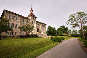
Wellington County House of Industry and Refuge
National Historic Site of Canada
Distance: Approx. 3092 meters
Latitude and longitude: 43.69305556,-80.39972222
The Wellington County House of Industry and Refuge, located in Fergus, Ontario, is the oldest surviving state-supported poorhouse in Canada. Constructed in 1877, the site operated as a poorhouse and farm until 1947, and as an old age home until 1971. In the 1980s, the building was repurposed to house the Wellington County Museum and Archives.
Weather in this IP's area
clear sky
13 Celsius
13 Celsius
13 Celsius
15 Celsius
1014 hPa
94 %
1014 hPa
966 hPa
10000 meters
1.03 m/s
50 degree
3 %
07:06:56
19:22:33