Country:
 Canada
Region:
City:
Latitude and Longitude:
Time Zone:
Postal Code:
IP information under different IP Channel
ip-api
Country
Region
City
ASN
Time Zone
ISP
Blacklist
Proxy
Latitude
Longitude
Postal
Route
IPinfo
Country
Region
City
ASN
Time Zone
ISP
Blacklist
Proxy
Latitude
Longitude
Postal
Route
MaxMind
Country
Region
City
ASN
Time Zone
ISP
Blacklist
Proxy
Latitude
Longitude
Postal
Route
Luminati
Country
CARegion
on
City
clifford
ASN
Time Zone
America/Toronto
ISP
WIGHT-AS
Latitude
Longitude
Postal
db-ip
Country
Region
City
ASN
Time Zone
ISP
Blacklist
Proxy
Latitude
Longitude
Postal
Route
ipdata
Country
Region
City
ASN
Time Zone
ISP
Blacklist
Proxy
Latitude
Longitude
Postal
Route
Popular places and events near this IP address
Fordwich Airport
Airport in Fordwich, Ontario
Distance: Approx. 8706 meters
Latitude and longitude: 43.88805556,-80.99527778
Fordwich Airport (TC LID: CPH9) is located 1.8 nautical miles (3.3 km; 2.1 mi) northeast of Fordwich, Ontario, Canada. Located on a farm, the single north/south runway consists of a grass strip with unobstructive trees and a pond at the south end; and a barn, silo and farmhouse at the north end. While the CFS notes that geese roost in the pond, a smudge pot is set up there to keep them away from the runway.

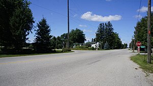
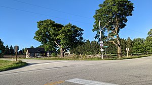
Clifford, Ontario
Unincorporated community in Ontario, Canada
Distance: Approx. 667 meters
Latitude and longitude: 43.9692,-80.9792
Clifford is an unincorporated community in the Town of Minto in Wellington County in Southwestern Ontario, Canada. It is on Ontario Highway 9 and Coon Creek, a stream in the Saugeen River drainage basin. The village of Clifford was founded around 1855 as Minto Village.
Yatton, Ontario
Place in Ontario, Canada
Distance: Approx. 2213 meters
Latitude and longitude: 43.98333333,-80.98333333
Yatton is an unincorporated rural community in Mapleton Township, Wellington County, Ontario, Canada.
Drew, Ontario
Community in Ontario, Canada
Distance: Approx. 7532 meters
Latitude and longitude: 43.9833,-80.8833
Drew is a rural farming community in Wellington County, Ontario, Canada, forming part of the Town of Minto. From the division of Minto into 18 concessions, Drew emerged from Concessions 16 and 17, spanning approximately five miles. Drew's main attractions include the Drew Ball Diamond and the Drew Community Centre.
Weather in this IP's area
clear sky
12 Celsius
12 Celsius
12 Celsius
13 Celsius
1014 hPa
96 %
1014 hPa
971 hPa
10000 meters
7 %
07:09:20
19:25:03