Country:
Region:
City:
Latitude and Longitude:
Time Zone:
Postal Code:
IP information under different IP Channel
ip-api
Country
Region
City
ASN
Time Zone
ISP
Blacklist
Proxy
Latitude
Longitude
Postal
Route
Luminati
Country
ASN
Time Zone
America/Chicago
ISP
USINTERNET
Latitude
Longitude
Postal
IPinfo
Country
Region
City
ASN
Time Zone
ISP
Blacklist
Proxy
Latitude
Longitude
Postal
Route
db-ip
Country
Region
City
ASN
Time Zone
ISP
Blacklist
Proxy
Latitude
Longitude
Postal
Route
ipdata
Country
Region
City
ASN
Time Zone
ISP
Blacklist
Proxy
Latitude
Longitude
Postal
Route
Popular places and events near this IP address

Medicine Lake, Minnesota
City in Minnesota, United States
Distance: Approx. 3547 meters
Latitude and longitude: 45.00194444,-93.42138889
Medicine Lake is an independent municipality in Hennepin County, Minnesota, United States located on a peninsula that juts into a lake of the same name. The population was 371 at the 2010 census.

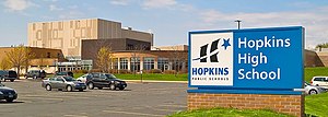
Hopkins High School
Public school in Minnetonka, Minnesota, United States
Distance: Approx. 2478 meters
Latitude and longitude: 44.9575604,-93.4128477
Hopkins High School is a public high school located in Minnetonka, Minnesota, United States. Hopkins High School is part of the Hopkins School District 270.

Ridgedale Center
Shopping mall in Minnesota, United States
Distance: Approx. 455 meters
Latitude and longitude: 44.968,-93.438
Ridgedale Center, colloquially known as Ridgedale, is an enclosed shopping mall in Minnetonka, Minnesota, a western suburb of the Twin Cities. It is directly located off I-394/US 12 between Ridgedale Drive and Plymouth Road (Hennepin CSAH 61). Ridgedale Center comprises 1,105,337 square feet (100,000 m2) of leaseable retail space, and contains approximately 140 retail tenants.
Adath Jeshurun Congregation
Synagogue in Minnetonka, Minnesota, USA
Distance: Approx. 2182 meters
Latitude and longitude: 44.962567,-93.412516
Adath Jeshurun Congregation (also Adath Jeshurun Synagogue) is a Conservative synagogue located in Minnetonka, Minnesota, in the United States, with about 1,200 members. Founded in 1884, it is a founding member of the United Synagogue of America, a founding member of the Women's League for Conservative Judaism, and the oldest affiliate of the United Synagogue of Conservative Judaism west of Chicago.

Charles H. Burwell House
Historic house in Minnesota, United States
Distance: Approx. 3521 meters
Latitude and longitude: 44.94138889,-93.44805556
The Charles H. Burwell House is a historic house museum in Minnetonka, Minnesota, United States, built in 1883. Charles H. Burwell (1838–1917) was the secretary and manager of the Minnetonka Mills Company, the first mill west of Minneapolis, around which grew the first permanent Euro-American settlement in Hennepin County west of Minneapolis. This property on Minnehaha Creek, including the house and two outbuildings, is listed on the National Register of Historic Places for its Carpenter Gothic/Stick style architecture and association with Minnetonka's early milling history.
B'nai Emet Synagogue (St. Louis Park, Minnesota)
Former synagogue in St. Louis, Minnesota, United States
Distance: Approx. 2185 meters
Latitude and longitude: 44.96256,-93.41247
B'nai Emet Synagogue is a former Conservative Jewish congregation and synagogue located on Ottawa Avenue, in St. Louis Park, Minnesota, in the United States. The synagogue had its origins in a number of earlier synagogues and congregations that merged in the course of a century, so that the earliest roots of B'nai Emet can be traced back from 1889 until it moved to its final location in 1956.
1959 PGA Championship
Golf tournament
Distance: Approx. 3410 meters
Latitude and longitude: 44.964,-93.395
The 1959 PGA Championship was the 41st PGA Championship played from July 30 to August 2 at Minneapolis Golf Club in St. Louis Park, Minnesota, a suburb west of Minneapolis. Six strokes back at the start of the final round, Bob Rosburg shot a 66 (−4) to win his only major championship at 277 (−3), one stroke ahead of runners-up Jerry Barber and Doug Sanders.
Minneapolis Golf Club
Golf club in St. Louis Park, Minnesota
Distance: Approx. 3384 meters
Latitude and longitude: 44.96416667,-93.39527778
Minneapolis Golf Club is a golf club located in St. Louis Park, Minnesota, a suburb of Minneapolis, Minnesota. Designed by Willie Park, Jr.
Central Baptist Theological Seminary of Minneapolis
Distance: Approx. 1986 meters
Latitude and longitude: 44.98833333,-93.42666667
Central Baptist Theological Seminary of Minneapolis is an Independent Baptist seminary in Plymouth, Minnesota. The seminary moved from Minneapolis to its present location in 1996.
Fourth Baptist Christian School
Private school in the United States
Distance: Approx. 1950 meters
Latitude and longitude: 44.988,-93.42672
Fourth Baptist Christian School, a ministry of Fourth Baptist Church, is a private Christian school located in Plymouth, Minnesota.

Metropoint Tower
Building in St. Louis Park, Minnesota
Distance: Approx. 2700 meters
Latitude and longitude: 44.975,-93.40277778
The Metropoint Tower, otherwise known as 600 Interchange Tower, is a 20-story high rise office building located in St. Louis Park, Minnesota, United States. Originally known as Shelard Tower upon its completion in 1975, the tower is the tallest building within the 494/694 interstate beltway outside of Minneapolis or Saint Paul, Minnesota.

Medicine Lake (Minnesota)
Distance: Approx. 4235 meters
Latitude and longitude: 45.00833333,-93.42083333
Medicine Lake is an inland lake located approximately 8 miles northwest of downtown Minneapolis, Minnesota. The lake lies within Hennepin County and is surrounded by two municipalities. At 902 acres, it is Hennepin County's second largest lake behind Lake Minnetonka and is popular among boaters, sailors, and fishers.
Weather in this IP's area
light rain
6 Celsius
3 Celsius
5 Celsius
7 Celsius
1007 hPa
95 %
1007 hPa
972 hPa
10000 meters
4.63 m/s
350 degree
100 %
06:58:21
16:56:22