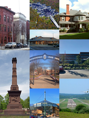
Country:
Region:
City:
Latitude and Longitude:
Time Zone:
Postal Code:
IP information under different IP Channel
ip-api
Country
Region
City
ASN
Time Zone
ISP
Blacklist
Proxy
Latitude
Longitude
Postal
Route
Luminati
Country
Region
md
City
fallston
ASN
Time Zone
America/New_York
ISP
SILVERSKY-INC
Latitude
Longitude
Postal
IPinfo
Country
Region
City
ASN
Time Zone
ISP
Blacklist
Proxy
Latitude
Longitude
Postal
Route
db-ip
Country
Region
City
ASN
Time Zone
ISP
Blacklist
Proxy
Latitude
Longitude
Postal
Route
ipdata
Country
Region
City
ASN
Time Zone
ISP
Blacklist
Proxy
Latitude
Longitude
Postal
Route
Popular places and events near this IP address

Danbury, Connecticut
City in Connecticut, United States
Distance: Approx. 2371 meters
Latitude and longitude: 41.40222222,-73.47111111
Danbury ( DAN-bair-ee) is a city in Fairfield County, Connecticut, United States, located approximately 50 miles (80 km) northeast of New York City. Danbury's population as of 2020 was 86,518. It is the third-largest city in Western Connecticut, and the seventh-largest city in Connecticut.

Federal Correctional Institution, Danbury
Low-security federal prison in Danbury, Connecticut, US
Distance: Approx. 1530 meters
Latitude and longitude: 41.4369,-73.4683
The Federal Correctional Institution, Danbury (FCI Danbury) is a low-security United States federal prison for male and female inmates in Danbury, Connecticut. It is operated by the Federal Bureau of Prisons, a division of the United States Department of Justice. The facility also has an adjacent satellite prison camp that houses minimum-security female offenders.

Danbury Hospital
Hospital in Connecticut, United States
Distance: Approx. 3067 meters
Latitude and longitude: 41.4054,-73.4447
Danbury Hospital is a 456-bed hospital in Danbury, Connecticut serving patients in Fairfield County, Connecticut, as well as Westchester County and Putnam County, New York. The hospital is part of the Nuvance Health system.

Danbury High School
Public school in Danbury, Connecticut, United States
Distance: Approx. 819 meters
Latitude and longitude: 41.4163,-73.4704
Danbury High School is a public high school in Danbury, Connecticut, with almost 4000 students. It is part of the Danbury Public Schools district. Despite Danbury's population of 86,518 (as of 2020), there is only one public high school, along with several small private schools, and one vocational high school in the city.
Henry Abbott Technical High School
Technical/vocational school in Danbury, Connecticut, United States
Distance: Approx. 1950 meters
Latitude and longitude: 41.4128,-73.4539
Henry Abbott Technical High School, or Abbott Tech, is a technical high school in Danbury, in Connecticut. It is among four high schools within Danbury, which include Danbury High School, Alternative Center for Excellence, and Immaculate High School. Abbott Tech receives students from many nearby towns.

Ball and Roller Bearing Company
United States historic place
Distance: Approx. 3269 meters
Latitude and longitude: 41.39833333,-73.45222222
The Ball and Roller Bearing Company, also known as American Family Crafts and the Joseph Nutt House and Machine Shop, is a historic industrial complex at 20-22 Maple Avenue in Danbury, Connecticut. Developed mainly in the early 20th century, the factory is most notable as the location where Lewis Heim invented the modern grinding machine, which revolutionized the manufacture of machine parts. The complex was listed on the National Register of Historic Places on August 25, 1989.
St. Gregory the Great Church, Danbury
Church in Connecticut, United States
Distance: Approx. 2715 meters
Latitude and longitude: 41.42791111,-73.44040556
St. Gregory the Great is a Roman Catholic church in Danbury, Connecticut, United States, part of the Diocese of Bridgeport.
St. Joseph Church (Danbury, Connecticut)
Church in Connecticut, United States
Distance: Approx. 2713 meters
Latitude and longitude: 41.40116111,-73.45941667
St. Joseph is a Roman Catholic church in Danbury, Connecticut, part of the Diocese of Bridgeport.

Great Plain, Danbury, Connecticut
Former farming community in Danbury, Connecticut, United States
Distance: Approx. 2801 meters
Latitude and longitude: 41.42158056,-73.43893889
Great Plain is an unincorporated area in the City of Danbury, Fairfield County, Connecticut. A former farming community, only remnants exist of this once thriving agricultural hub.

Hayestown, Connecticut
Lakeside neighborhood Danbury, Connecticut, United States
Distance: Approx. 1604 meters
Latitude and longitude: 41.42009722,-73.45373333
Hayestown is an unincorporated area in Danbury, Connecticut. It is located in the eastern section of the city, along the southern shoreline of Candlewood Lake, west of Great Plain, northwest of Germantown, and east of Clapboard Ridge.

King Street, Danbury, Connecticut
Residential neighborhood in Danbury, Connecticut, United States
Distance: Approx. 3106 meters
Latitude and longitude: 41.43188889,-73.50788889
King Street is a residential neighborhood and former district in Danbury, Connecticut. Located in the northwest corner of the city, it borders the Milltown section of Southeast, New York to the west and the town of New Fairfield, Connecticut, to the north. The name King Street is an eponym of its main thoroughfares: King, South King, West King, and East King Streets.
Germantown, Danbury, Connecticut
Neighborhood in Danbury, Connecticut, United States
Distance: Approx. 3036 meters
Latitude and longitude: 41.4081504,-73.4423441
Germantown is a neighborhood in the city of Danbury, Fairfield County, Connecticut, United States. This section is on the eastern side of Danbury, with Hospital Avenue as its main thoroughfare. It is named after the German immigrants who lived there during the 19th century to work in Danbury's hat factories.
Weather in this IP's area
clear sky
14 Celsius
13 Celsius
13 Celsius
16 Celsius
1013 hPa
50 %
1013 hPa
992 hPa
10000 meters
4.63 m/s
270 degree
06:34:32
16:40:53