165.173.191.204 - IP Lookup: Free IP Address Lookup, Postal Code Lookup, IP Location Lookup, IP ASN, Public IP
Country:
Region:
City:
Location:
Time Zone:
Postal Code:
IP information under different IP Channel
ip-api
Country
Region
City
ASN
Time Zone
ISP
Blacklist
Proxy
Latitude
Longitude
Postal
Route
Luminati
Country
ASN
Time Zone
Australia/Sydney
ISP
Zoho Corporation PTY LTD
Latitude
Longitude
Postal
IPinfo
Country
Region
City
ASN
Time Zone
ISP
Blacklist
Proxy
Latitude
Longitude
Postal
Route
IP2Location
165.173.191.204Country
Region
new south wales
City
byron bay
Time Zone
Australia/Sydney
ISP
Language
User-Agent
Latitude
Longitude
Postal
db-ip
Country
Region
City
ASN
Time Zone
ISP
Blacklist
Proxy
Latitude
Longitude
Postal
Route
ipdata
Country
Region
City
ASN
Time Zone
ISP
Blacklist
Proxy
Latitude
Longitude
Postal
Route
Popular places and events near this IP address

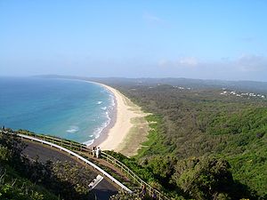
Byron Bay
Town in New South Wales, Australia
Distance: Approx. 343 meters
Latitude and longitude: -28.64305556,153.615
Byron Bay (Minjungbal: Cavvanbah) is a beachside town located in the far-northeastern corner of New South Wales, Australia (in Bundjalung Country). It is located 772 kilometres (480 mi) north of Sydney and 165 kilometres (103 mi) south of Brisbane. Cape Byron, a headland adjacent to the town, is the easternmost point of mainland Australia.

Cape Byron
Easternmost point of mainland Australia
Distance: Approx. 2814 meters
Latitude and longitude: -28.632778,153.638889
Cape Byron is the easternmost point of the mainland of Australia, located in New South Wales. It is about 3 km (1.9 mi) east of the town of Byron Bay, New South Wales and projects into the Pacific Ocean at 28.6335° S, 153.6383° E. A lighthouse is situated there. It is a popular area for hiking and for whale watching.
Bay FM (Byron Bay)
Distance: Approx. 328 meters
Latitude and longitude: -28.64444444,153.61277778
Bay FM (call sign: 2BAY) is a community radio station serving the Byron Shire and beyond from Byron Bay, New South Wales, Australia. Totally volunteer run, Bay FM aims to provide independent community-responsive radio informing and entertaining locally and globally. Locally, the station's frequency is 99.9 MHz and it covers the Northern Rivers region of New South Wales.
Arakwal National Park
Protected area in New South Wales, Australia
Distance: Approx. 2266 meters
Latitude and longitude: -28.66027778,153.62111111
Arakwal National Park is a national park in New South Wales, Australia, 624 km north of Sydney and immediately south of Cape Byron, the most easterly point of mainland Australia. The park protects an area of Wallum country, of coastal clay heaths, between the adjacent town of Byron Bay and east-facing Tallow Beach. It provides habitat to numerous bird species and two native frog species, the Wallum Froglet (Crinia tinnula) and Wallum Sedge Frog (Litoria olongburensis), both of which are deemed vulnerable to extinction.

The Wreck (surf spot)
Distance: Approx. 524 meters
Latitude and longitude: -28.637086,153.610378
The Wreck is a surf spot located at Byron Bay, New South Wales, Australia. It is approximately 30 metres (98 ft) off the shore of Belongil Beach (at the town end), and approximately 60 metres (200 ft) from the Main Beach Car Park.
Byron Bay High School
Secondary school in Byron Bay, Australia
Distance: Approx. 2826 meters
Latitude and longitude: -28.66674722,153.61586111
Byron Bay High School is a government-funded co-educational comprehensive secondary day school, located in Byron Bay, New South Wales, Australia. The school, which is designed in the shape of a nautilus shell, opened on 15 May 1987. Facilities of the school include: agriculture centre, basketball courts, canteen, car park, changing rooms, library, multi-purpose centre, performing arts centre, sports centre and sports pitch.

Cape Byron Light
Lighthouse in New South Wales, Australia
Distance: Approx. 2416 meters
Latitude and longitude: -28.63861111,153.63638889
Cape Byron Light, also called Cape Byron Lightstation, is an active heritage-listed lighthouse and now interpretative centre, interpretative space, maritime museum, administration office, retail building, accommodation, tourist attraction and visitor attraction located at Cape Byron on the Far North Coast of New South Wales, Australia. It was designed by Charles Harding and Cecil W. Darley and built from 1899 to 1901 by Messrs Mitchell & King. It is also known as Cape Byron Lightstation (including moveable items), Byron Bay Lighthouse, Cape Byron Headland and Cape Byron Headland Reserve.
SS Wollongbar (1911)
Distance: Approx. 524 meters
Latitude and longitude: -28.637086,153.610378
SS Wollongbar was a 2,005-ton passenger steamship built by the Ailsa Shipbuilding Company, Troon in 1911 for the North Coast Steam Navigation Company.
MV Tassie III
Distance: Approx. 369 meters
Latitude and longitude: -28.638795,153.613906
MV Tassie III (S-77) was a 120-ton steel motor vessel, which was requisitioned by the United States Army during the Second World War. She was carrying 80 tons of condemned ammunition when she was wrecked 28.638795°S 153.613906°E / -28.638795; 153.613906 while sheltering at the jetty at Byron Bay, New South Wales, Australia, on 9 June 1945. The Australian salvage tug Tancred salvaged most of the ammunition from the wreck in 1946.
List of shipwrecks in June 1945
Distance: Approx. 369 meters
Latitude and longitude: -28.638795,153.613906
The list of shipwrecks in June 1945 includes ships sunk, foundered, grounded, or otherwise lost during June 1945.

Byron Bay railway station
Former railway station in New South Wales,
Distance: Approx. 324 meters
Latitude and longitude: -28.6445,153.6116
Byron Bay railway station is a former railway station located on the Murwillumbah line in Byron Bay, New South Wales, Australia. It opened on 15 May 1894 and closed on 16 May 2004, when the line from Casino was closed. The station complex was built from 1894 to 1913.
Byron Bay Post Office
Historic site in New South Wales, Australia
Distance: Approx. 302 meters
Latitude and longitude: -28.6442,153.6128
Byron Bay Post Office is a heritage-listed post office at 61 Jonson Street, Byron Bay, New South Wales, Australia. It was added to the Australian Commonwealth Heritage List on 22 August 2012.
Weather in this IP's area
light rain
28 Celsius
29 Celsius
28 Celsius
28 Celsius
1015 hPa
58 %
1015 hPa
1014 hPa
10000 meters
3.66 m/s
3.67 m/s
118 degree
100 %
