165.166.244.59 - IP Lookup: Free IP Address Lookup, Postal Code Lookup, IP Location Lookup, IP ASN, Public IP
Country:
Region:
City:
Location:
Time Zone:
Postal Code:
ISP:
ASN:
language:
User-Agent:
Proxy IP:
Blacklist:
IP information under different IP Channel
ip-api
Country
Region
City
ASN
Time Zone
ISP
Blacklist
Proxy
Latitude
Longitude
Postal
Route
db-ip
Country
Region
City
ASN
Time Zone
ISP
Blacklist
Proxy
Latitude
Longitude
Postal
Route
IPinfo
Country
Region
City
ASN
Time Zone
ISP
Blacklist
Proxy
Latitude
Longitude
Postal
Route
IP2Location
165.166.244.59Country
Region
south carolina
City
north charleston
Time Zone
America/New_York
ISP
Language
User-Agent
Latitude
Longitude
Postal
ipdata
Country
Region
City
ASN
Time Zone
ISP
Blacklist
Proxy
Latitude
Longitude
Postal
Route
Popular places and events near this IP address
North Charleston, South Carolina
City in South Carolina, United States
Distance: Approx. 4070 meters
Latitude and longitude: 32.88527778,-80.01694444
North Charleston is a city in Berkeley, Charleston, and Dorchester counties in the U.S. state of South Carolina. As of the 2020 census, North Charleston had a population of 114,852, making it the third-most populous city in the state, and the 248th-most populous city in the United States. North Charleston is a principal city within the Charleston-North Charleston, SC Metropolitan Statistical Area, which had an estimated population of 849,417 in 2023.

Charleston International Airport
Airport serving Charleston, South Carolina, USA
Distance: Approx. 1878 meters
Latitude and longitude: 32.89861111,-80.04055556
Charleston International Airport (IATA: CHS, ICAO: KCHS, FAA LID: CHS) is a joint civil-military airport located in North Charleston, South Carolina, United States. The airport is operated by the Charleston County Aviation Authority under a joint-use agreement with Joint Base Charleston. It is South Carolina's busiest airport; in 2023 the airport served over 6.1 million passengers in its busiest year on record.

Charleston Air Force Base
US Air Force Base in South Carolina
Distance: Approx. 1878 meters
Latitude and longitude: 32.89861111,-80.04055556
Charleston Air Force Base (IATA: CHS, ICAO: KCHS, FAA LID: CHS) is a United States military facility located in the City of North Charleston, South Carolina. The facility is under the jurisdiction of the United States Air Force's 628th Air Base Wing (628 ABW), a subordinate element of the Air Mobility Command (AMC). It is part of Joint Base Charleston, which combined Charleston Air Force Base with Naval Support Activity Charleston.

Drayton Hall
Historic house in South Carolina, United States
Distance: Approx. 2919 meters
Latitude and longitude: 32.8709,-80.0763
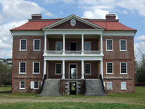
Drayton Hall is an 18th-century plantation house located on the Ashley River about 15 miles (24 km) northwest of Charleston, South Carolina, and directly across the Ashley River from North Charleston, west of the Ashley in the Lowcountry. An example of Palladian architecture in North America and the only plantation house on the Ashley River to survive intact through both the Revolutionary and Civil wars, it is a National Historic Landmark.

Audubon Swamp Garden
Distance: Approx. 3440 meters
Latitude and longitude: 32.87472222,-80.08916667
Audubon Swamp Garden is a 60-acre (24 ha) cypress and tupelo swamp on the grounds of Magnolia Plantation near Charleston, South Carolina, United States. At one time, the swamp served as a reservoir for the plantation's rice cultivation. The swamp garden includes native flora and non-native, exotic plantings and is home to herons, ibis, turtles, otters, alligators, and other wildlife.

Magnolia Plantation and Gardens (Charleston, South Carolina)
Historic house in South Carolina, United States
Distance: Approx. 2900 meters
Latitude and longitude: 32.87651,-80.08351
Magnolia Plantation and Gardens (464 acres, 187.77 hectares) is a historic house with gardens located on the Ashley River at 3550 Ashley River Road west of Ashley, Charleston County, South Carolina. It is one of the oldest plantations in the South, and listed on the National Register of Historic Places. Magnolia Plantation is located near Charleston and directly across the Ashley River from North Charleston.
North Charleston Air Force Station
Closed United States Air Force General Surveillance Radar station
Distance: Approx. 3496 meters
Latitude and longitude: 32.89555556,-80.02222222
North Charleston Air Force Station (ADC ID: M-113 NORAD ID: Z-113) is a closed United States Air Force General Surveillance Radar station. It is located in the City of North Charleston, South Carolina. It was closed in 1980.

Joint Base Charleston
US Armed Forces facility in South Carolina
Distance: Approx. 1878 meters
Latitude and longitude: 32.89861111,-80.04055556
Joint Base Charleston (IATA: CHS, ICAO: KCHS, FAA LID: CHS) is a United States military facility located partly in the city of North Charleston, South Carolina and partly in the city of Goose Creek, South Carolina. The facility is under the jurisdiction of the United States Air Force 628th Air Base Wing, Air Mobility Command (AMC). The facility is an amalgamation of the United States Air Force Charleston Air Force Base and the United States Navy Naval Support Activity Charleston which were merged on October 1, 2010.
Killing of Walter Scott
2015 fatal shooting in North Charleston, South Carolina
Distance: Approx. 4246 meters
Latitude and longitude: 32.8982,-80.0145
On April 4, 2015, Walter Scott, a 50-year-old black man, was fatally shot by Michael Slager, a local police officer in North Charleston, South Carolina, United States. Slager had stopped Scott for a non-functioning brake light. Slager was charged with murder after a video surfaced showing him shooting Scott from behind while Scott was fleeing, which contradicted Slager's report of the incident.

North Charleston Fire Museum
Fire Museum in North Charleston, SC
Distance: Approx. 4574 meters
Latitude and longitude: 32.8707,-80.0184
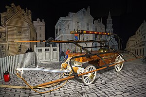
The North Charleston Fire Museum and Educational Center is a fire museum in North Charleston, South Carolina, displaying a collection of fire fighting vehicles dating back to the 1780s. On permanent loan from the American LaFrance Company, which was headquartered nearby until its closure in 2014, the 20,000 square feet (1,900 m2) facility displays more than 20 restored vehicles, interactive exhibits and simulators. Established in 2007 by the city of North Charleston, the museum is a popular rainy day activity for tourists.
R.B. Stall High School
Public high school in North Charleston, South Carolina
Distance: Approx. 3816 meters
Latitude and longitude: 32.9226,-80.0801
R.B. Stall High School is a public high school in North Charleston, South Carolina. It has a Charleston postal address. It is a part of the Charleston County School District (CCSD).

Runnymede Plantation
Distance: Approx. 3407 meters
Latitude and longitude: 32.88222222,-80.09361111
Runnymede was a plantation home at 3760 Ashley River Road near Charleston, South Carolina. The land borders Magnolia Gardens to the southeast. The plantation existed at least by 1705 when John Cattell acquired the tract.
Weather in this IP's area
broken clouds
2 Celsius
-3 Celsius
2 Celsius
3 Celsius
1026 hPa
45 %
1026 hPa
1025 hPa
10000 meters
6.17 m/s
330 degree
75 %
