Country:
 USA
USARegion:
City:
Latitude and Longitude:
Time Zone:
Postal Code:
IP information under different IP Channel
ip-api
Country
Region
City
ASN
Time Zone
ISP
Blacklist
Proxy
Latitude
Longitude
Postal
Route
IPinfo
Country
Region
City
ASN
Time Zone
ISP
Blacklist
Proxy
Latitude
Longitude
Postal
Route
MaxMind
Country
Region
City
ASN
Time Zone
ISP
Blacklist
Proxy
Latitude
Longitude
Postal
Route
Luminati
Country
USRegion
sc
City
chesnee
ASN
Time Zone
America/New_York
ISP
ROCK-HILL-TELEPHONE
Latitude
Longitude
Postal
db-ip
Country
Region
City
ASN
Time Zone
ISP
Blacklist
Proxy
Latitude
Longitude
Postal
Route
ipdata
Country
Region
City
ASN
Time Zone
ISP
Blacklist
Proxy
Latitude
Longitude
Postal
Route
Popular places and events near this IP address

Mayo, South Carolina
CDP in South Carolina, United States
Distance: Approx. 3437 meters
Latitude and longitude: 35.08805556,-81.85111111
Mayo is a census-designated place (CDP) in Spartanburg County, South Carolina, United States. The population was 1,592 at the 2010 census.
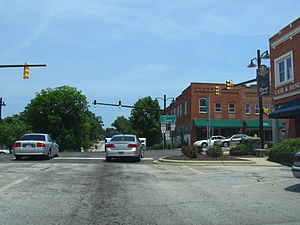
Chesnee, South Carolina
City in South Carolina, United States
Distance: Approx. 3863 meters
Latitude and longitude: 35.14833333,-81.86194444
Chesnee is a city in Spartanburg and Cherokee counties, in the U.S. state of South Carolina. The population was 868 as of the 2010 census.

Battle of Cowpens
1781 battle during the American Revolutionary War
Distance: Approx. 5579 meters
Latitude and longitude: 35.13683333,-81.816
The Battle of Cowpens was a military engagement during the American Revolutionary War fought on January 17, 1781, near the town of Cowpens, South Carolina. American Patriot forces, estimated at 2,000 militia and regulars under Brigadier General Daniel Morgan faced 1,000 British troops under Lieutenant Colonel Banastre Tarleton,. The American victory was the worst loss suffered by British units since General John Burgoyne surrendered to General Horatio Gates at the Saratoga in 1777.
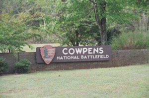
Cowpens National Battlefield
Unit of the National Park Service in South Carolina, United States
Distance: Approx. 5404 meters
Latitude and longitude: 35.13666667,-81.81805556
Cowpens National Battlefield is a unit of the National Park Service just east of Chesnee, South Carolina, and near the state line with North Carolina. It preserves a major battlefield of the American Revolutionary War. Brigadier General Daniel Morgan won the Battle of Cowpens, a decisive Revolutionary War victory over British Lieutenant Colonel Banastre Tarleton on January 17, 1781.
WYFG
Radio station in Gaffney, South Carolina
Distance: Approx. 8452 meters
Latitude and longitude: 35.116,-81.778
WYFG (91.1 FM) is a radio station simulcasting the Bible Broadcasting Network for the Gaffney, Spartanburg, and Greenville areas of South Carolina as well as some of the western suburbs of the Charlotte area. The transmitter is located off South Carolina Highway 11 atop Thicketty Mountain (which is about 5 miles east of Chesnee).
Lake Blalock
Reservoir in South Carolina, United States
Distance: Approx. 4442 meters
Latitude and longitude: 35.075,-81.8785
Lake Blalock (formally, the H. Taylor Blalock Reservoir) is a reservoir in Spartanburg County, South Carolina, located on the Pacolet River about five miles north of Spartanburg. After its creation was authorized in 1976 by the Commissioners of Spartanburg Water System, Blalock Dam was constructed in 1983. The existing earthen dam is approximately 700 ft (210 m).
Chesnee High School
School in Chesnee, South Carolina, United States
Distance: Approx. 2287 meters
Latitude and longitude: 35.13305556,-81.86027778
Chesnee High School is a 9–12 grade campus located in the northern part of Spartanburg County, South Carolina. The campus is located in the foothills of the Blue Ridge Mountains. The school has an average enrollment of approximately 700 students and offers numerous sports including: football, baseball, softball, competitive cheer, wrestling, golf, tennis, fishing, and competitive marching band.
Cherokee Springs, South Carolina
Unincorporated community in South Carolina, US
Distance: Approx. 7428 meters
Latitude and longitude: 35.04972222,-81.89083333
Cherokee Springs is an unincorporated community in Spartanburg County, in the U.S. state of South Carolina.
Thicketty Mountain
Distance: Approx. 9323 meters
Latitude and longitude: 35.112903,-81.768435
Thicketty Mountain is a mountain summit in northwestern Cherokee County in the state of South Carolina. Thicketty Mountain climbs to an elevation of around 1,194 feet (364 meters). Thicketty Mountain is also one of the three mountain peaks of Cherokee County.
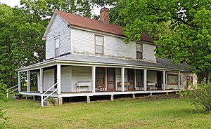
Zeno Hicks House
Historic house in South Carolina, United States
Distance: Approx. 4396 meters
Latitude and longitude: 35.15194444,-81.85583333
The Zeno Hicks House, also known as the McKinney-Hicks Homeplace, is a historic home and national historic district near Chesnee, South Carolina. The district encompasses one contributing building and one contributing structure. The house, built in 1886, is a two-story rectangular frame I-house built of weatherboard and hand sawn from heart pine.
State Line, South Carolina
Unincorporated community in South Carolina, US
Distance: Approx. 9465 meters
Latitude and longitude: 35.17666667,-81.8
State Line is an unincorporated community in Cherokee County, in the U.S. state of South Carolina.
Ezell, South Carolina
Distance: Approx. 5574 meters
Latitude and longitude: 35.13777778,-81.81666667
Ezell is a ghost town in Cherokee County, in the U.S. state of South Carolina.
Weather in this IP's area
clear sky
20 Celsius
19 Celsius
18 Celsius
21 Celsius
1020 hPa
46 %
1020 hPa
990 hPa
10000 meters
1.33 m/s
1.95 m/s
159 degree
07:30:23
18:57:27