Country:
 USA
USARegion:
City:
Latitude and Longitude:
Time Zone:
Postal Code:
IP information under different IP Channel
ip-api
Country
Region
City
ASN
Time Zone
ISP
Blacklist
Proxy
Latitude
Longitude
Postal
Route
IPinfo
Country
Region
City
ASN
Time Zone
ISP
Blacklist
Proxy
Latitude
Longitude
Postal
Route
MaxMind
Country
Region
City
ASN
Time Zone
ISP
Blacklist
Proxy
Latitude
Longitude
Postal
Route
Luminati
Country
USRegion
mo
City
stlouis
ASN
Time Zone
America/Chicago
ISP
SLU
Latitude
Longitude
Postal
db-ip
Country
Region
City
ASN
Time Zone
ISP
Blacklist
Proxy
Latitude
Longitude
Postal
Route
ipdata
Country
Region
City
ASN
Time Zone
ISP
Blacklist
Proxy
Latitude
Longitude
Postal
Route
Popular places and events near this IP address
Roman Catholic Archdiocese of St. Louis
Latin Catholic ecclesiastical jurisdiction in US
Distance: Approx. 63 meters
Latitude and longitude: 38.64277778,-90.25722222
The Archdiocese of St. Louis (Latin: Archidiœcesis Sancti Ludovici) is a Latin Church ecclesiastical territory or archdiocese of the Catholic Church that covers the City of St. Louis and the Missouri counties of Franklin, Jefferson, Lincoln, Perry, Saint Charles, Saint Francois, Ste.

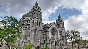
Cathedral Basilica of Saint Louis (St. Louis)
Church in Missouri, United States
Distance: Approx. 257 meters
Latitude and longitude: 38.6425,-90.25472222
The Cathedral Basilica of Saint Louis, also known as the Saint Louis Cathedral, is a Catholic cathedral in the Central West End neighborhood of St. Louis, Missouri. Completed in 1914, it is the mother church of the Archdiocese of St.
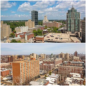
Central West End, St. Louis
Neighborhood of St. Louis in Missouri, United States
Distance: Approx. 408 meters
Latitude and longitude: 38.6403,-90.2548
The Central West End is a neighborhood in St. Louis, Missouri, stretching from Midtown's western edge to Union Boulevard and bordering on Forest Park with its array of free cultural institutions. It includes the Cathedral Basilica of Saint Louis (the New Cathedral) on Lindell Boulevard at Newstead Avenue, which houses the second-largest collection of mosaics in the world.

Rosati-Kain High School
Catholic school in St. Louis, Missouri, US
Distance: Approx. 353 meters
Latitude and longitude: 38.642,-90.2538
Rosati-Kain High School is an all-girls Catholic high school in St. Louis, Missouri. Rosati-Kain is accredited as a college preparatory school by the North Central Association, the Missouri Department of Education, and the Roman Catholic Archdiocese of Saint Louis.

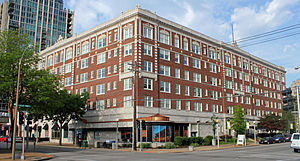
Chase Park Plaza Hotel
Building in Missouri, United States
Distance: Approx. 564 meters
Latitude and longitude: 38.64416667,-90.26388889
The Chase Park Plaza Royal Sonesta St. Louis is a historic hotel and apartment complex located at 212 N. Kingshighway Boulevard in the Central West End of St. Louis, Missouri.
Forest Park Hotel
United States historic place
Distance: Approx. 462 meters
Latitude and longitude: 38.64138889,-90.26222222
The Forest Park Hotel is a six-story building located in the Central West End neighborhood of St. Louis, Missouri and listed on the National Register of Historic Places. The six-story building was built in 1923 and is made of reinforced concrete with red brick curtain walls trimmed with terra cotta.

Buckingham Hotel
Distance: Approx. 607 meters
Latitude and longitude: 38.64277778,-90.26444444
Buckingham Hotel, later the Ambassador Hotel, was an upmarket hotel which existed in St. Louis, Missouri, United States, in the early 20th century. It was located on the northeast corner of North Kingshighway and West Pine boulevards.

Second Presbyterian Church (St. Louis, Missouri)
Historic church in Missouri, United States
Distance: Approx. 497 meters
Latitude and longitude: 38.6475,-90.25555556
Second Presbyterian Church is a historic church at 4501 Westminster Place in St. Louis, Missouri.

Butler House (St. Louis, Missouri)
Historic house in Missouri, United States
Distance: Approx. 299 meters
Latitude and longitude: 38.640616,-90.257735
The Butler House is a turreted, brick house built in 1892 for prominent St. Louis tobacco manufacturer James Gay Butler. It was designed in the Queen Anne style by Albert Knell, a Canadian architect.

One Hundred Above the Park
Apartment building in St. Louis, United States
Distance: Approx. 624 meters
Latitude and longitude: 38.64271,-90.26464
One Hundred is an apartment tower located at 100 N Kingshighway Blvd. in the Central West End neighborhood of St. Louis, Missouri, in the United States.

Bel Air Motel
Historic motel in St. Louis, Missouri, US
Distance: Approx. 296 meters
Latitude and longitude: 38.64277778,-90.26083333
Bel Air Motel, also known as Bel Air West, was a historic building and motel in the Central West End neighborhood in St. Louis, Missouri, U.S.. It is listed as one of the National Register of Historic Places since 2009.
Mainlander (restaurant)
Restaurant in St. Louis, Missouri, U.S.
Distance: Approx. 541 meters
Latitude and longitude: 38.639979,-90.262041
Mainlander is a restaurant in St. Louis, Missouri. It was a semifinalist in the Best New Restaurant category of the James Beard Foundation Awards in 2024.
Weather in this IP's area
clear sky
32 Celsius
34 Celsius
31 Celsius
34 Celsius
1009 hPa
46 %
1009 hPa
993 hPa
10000 meters
1.34 m/s
2.24 m/s
223 degree
3 %
06:46:32
19:02:50