Country:
 USA
USARegion:
City:
Latitude and Longitude:
Time Zone:
Postal Code:
IP information under different IP Channel
ip-api
Country
Region
City
ASN
Time Zone
ISP
Blacklist
Proxy
Latitude
Longitude
Postal
Route
IPinfo
Country
Region
City
ASN
Time Zone
ISP
Blacklist
Proxy
Latitude
Longitude
Postal
Route
MaxMind
Country
Region
City
ASN
Time Zone
ISP
Blacklist
Proxy
Latitude
Longitude
Postal
Route
Luminati
Country
USRegion
mo
City
stlouis
ASN
Time Zone
America/Chicago
ISP
SLU
Latitude
Longitude
Postal
db-ip
Country
Region
City
ASN
Time Zone
ISP
Blacklist
Proxy
Latitude
Longitude
Postal
Route
ipdata
Country
Region
City
ASN
Time Zone
ISP
Blacklist
Proxy
Latitude
Longitude
Postal
Route
Popular places and events near this IP address
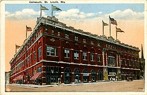
St. Louis Coliseum
Convention center in Missouri, United States
Distance: Approx. 379 meters
Latitude and longitude: 38.634937,-90.213847
The St. Louis Coliseum was a venue in St. Louis, Missouri.

Peacock Alley (jazz club)
Distance: Approx. 354 meters
Latitude and longitude: 38.63333333,-90.22166667
The Peacock Alley was a jazz club at 2935 Lawton Boulevard St. Louis, Missouri. It was one of St.

Scott Joplin House State Historic Site
Historic house in St. Louis, Missouri
Distance: Approx. 485 meters
Latitude and longitude: 38.63705556,-90.215
The Scott Joplin House State Historic Site is located at 2658 Delmar Boulevard in St. Louis, Missouri. It preserves the Scott Joplin Residence, the home of composer Scott Joplin from 1901 to 1903.
YWCA, Phillis Wheatley Branch
United States historic place
Distance: Approx. 174 meters
Latitude and longitude: 38.63444444,-90.21638889
The YWCA, Phillis Wheatley Branch in St. Louis, Missouri is a building dating from 1927. It was listed on the National Register of Historic Places in 1984.

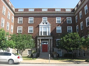
Harris–Stowe State University
Historically black public university in St. Louis, Missouri, US
Distance: Approx. 571 meters
Latitude and longitude: 38.63333333,-90.22416667
Harris–Stowe State University (HSSU) is a public university. It is in St. Louis, Missouri.
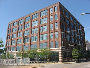
Willys–Overland Building
United States historic place
Distance: Approx. 536 meters
Latitude and longitude: 38.63555556,-90.21222222
The Willys–Overland Building is a former automobile dealership and distribution building for the Willys-Overland Company in St. Louis, Missouri located at 2300 Locust Street. The building was the home of the company's main dealership and distributor in St.

Unitarian Church of the Messiah
United States historic place
Distance: Approx. 441 meters
Latitude and longitude: 38.63583333,-90.22138889
The Unitarian Church of the Messiah was a church at 508 North Garrison Avenue at the corner of Locust and Garrison Sts. in St. Louis, Missouri, USA and was the third church of the St.

Central Baptist Church (St. Louis, Missouri)
Church in St. Louis, Missouri
Distance: Approx. 348 meters
Latitude and longitude: 38.636008,-90.219358
Central Baptist Church in St. Louis, Missouri was founded as the Second African Baptist Church in 1846. Early pastors were Reverend Richard Sneethen, (1846-1847) and Reverend John Richard Anderson, (1847-1863).

Autocar Sales and Service Building
United States historic place
Distance: Approx. 232 meters
Latitude and longitude: 38.63527778,-90.21777778
The Autocar Sales and Service Building, at 2745 Locust in St. Louis, Missouri, was built in 1917. It was listed on the National Register of Historic Places in 2006.

More Automobile Company Building
United States historic place
Distance: Approx. 235 meters
Latitude and longitude: 38.63527778,-90.21805556
The More Automobile Company Building, at 2801 Locust St. in St. Louis, Missouri, was built in 1920.

Berry Motor Car Service Building
United States historic place
Distance: Approx. 558 meters
Latitude and longitude: 38.63444444,-90.21138889
The Berry Motor Car Service Building, at 2220 Washington Ave in St. Louis, Missouri, was built in 1937. It was listed on the National Register of Historic Places in 2010.

Mill Creek Valley
Place
Distance: Approx. 381 meters
Latitude and longitude: 38.63277778,-90.22194444
Mill Creek Valley was a historic neighborhood located in the central corridor between 20th Street and Saint Louis University in St. Louis, Missouri. European settlement began in the 18th century with mills established along La Petite Rivière, now known as Mill Creek.
Weather in this IP's area
clear sky
32 Celsius
33 Celsius
30 Celsius
33 Celsius
1009 hPa
44 %
1009 hPa
992 hPa
10000 meters
5.14 m/s
160 degree
06:46:23
19:02:40